The Time Lapse 360° de Martin
Voilà, on est très très content de la nouvelle, en fait ça fait un p'tit moment qu'on l'attendait. Même un grand moment, mais des fois les choses ne se passent pas comme on le souhaite...
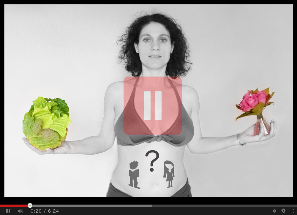
Il y a tout juste un an, mi-septembre 2013, voici qu'une très bonne nouvelle se profilait pour l'été 2014 ! Florence venait de tomber enceinte, et pour cette occasion, j'ai souhaité garder le meilleur souvenir possible de la grossesse.
En même temps que démarrait une formidable aventure humaine, je débutais alors mon plus gros projet photo 360° : j'ai pris toute une série de photos, jour après jour, du début de la grossesse jusqu'à l'accouchement, puis lors du retour à la maison de Martin.
Ainsi, j'ai pris un peu plus de 12 000 photos sur une période d'environ 300 jours.
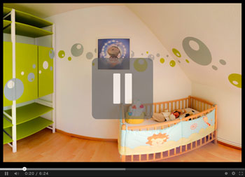
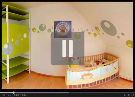
Sauf que prendre une succession de photos avec Florence immobile dans la chambre aurait été trop simple ! Je me suis mis en tête de prendre une multitude de photos afin de créer à chaque fois un panoramique sphérique 360° complet, retraçant d'une part le déplacement et la grossesse de Florence, mais aussi l'évolution de la future chambre de Martin : à partir des 12 000 photos, j'ai créé 810 images panoramiques (où l'on peut regarder tout autour de soi). Je les ai ensuite mises les unes à la suite des autres, pour composer un court-métrage de 6min qui retrace l'évolution de la grossesse de façon accélérée : c'est le principe des vidéos "Time-Lapse".
Après des heures et des heures (je n'ai pas compté, mais à la louche, il y a beaucoup plus que 3000h) de travail, de retouches, de traitement, d'ajustement et de montage, je peux enfin vous proposer "Le Time-Lapse de Martin".
Cliquez sur l'image ci-dessous pour lancer la vidéo. Elle est aussi disponible
sur Vimeo pour les internautes ne pouvant pas la regarder sur Youtube.
Le Time Lapse Sphérique 360° de Martin
 Le Time-Lapse Sphérique 360° de Martin est une animation d'un peu plus de 6 minutes réalisée à partir de 810
panoramas équirectangulaires : ce sont des images de 50Mpx, mesurant 10 000px de long par 5 000px de large.
Ces images ont un type de projection particulier : elles possèdent un angle de champ de 360° par 180°. Pour créer ces
images panoramiques, il a fallu prendre et assembler un peu plus de 12 000 images sur une période d'environ 300 jours !
La vidéo sphérique 360° de Martin
Mais je ne me suis pas arrêté là !
Dans la précédente vidéo, un montage et une animation spécifique ont été réalisé à partir des 810 images panoramiques 360º. Le spectateur (en l'occurrence l'internaute) visionne la vidéo, mais il n'est pas acteur de la caméra !
J'ai donc décidé de créer une autre version de cette vidéo, cette fois-ci complètement interactive ! Elle s'intitule : "La vidéo sphérique 360º de Martin".
Ainsi, l'internaute décide grâce à la souris, de visionner l'endroit qu'il souhaite. Il est complètement acteur de son film !
Par contre, pour visionner cette vidéo, je vous laisse choisir la résolution souhaitée de l'affichage (en cliquant sur le lien ci-dessous), tout simplement car suivant la puissance de votre ordinateur et votre connexion ADSL, cela risque d'être saccadé ...
Appuyez sur le bouton "Lecture" pour lancer la vidéo, puis bougez le curseur de la souris
afin de vous déplacer dans le panoramique et suivre l'évolution de la grossesse !
Ce film sphérique 360° est disponible dans une résolution native de 10 000px par 5 000px, sans interpolation d'images. Il a bien fallu faire des compromis (temps de calculs principalement) lors de la création des images panoramiques, sinon il aurait pu être encore un peu plus grand ! Pour des raisons de bande passante et de fluidité d'affichage, la résolution finale a bien évidemment été réduite.
Suivant les normes actuelles, on peut dire que ce film est en résolution 10K ! Pour comparaison, la coupe du monde de football 2014 a été filmée et diffusée en 4K sur quelques chaines, et la finale a été filmée à 360° en 8K grâce à une capture panoramique...
Cette vidéo sphérique 360° d'une telle résolution est donc une première mondiale !
Welcome on 360x180.fr !
Sphérical  panoramas have a field of view of 360° by 180°. To experience total immersion,
click on the image and then move the mouse to look around you.
Latest publications
You will find below the last three panoramas on this page.
⤷ To view the last 15 panoramas published on this website click here.
⤷ If you want to watch another 360° panorama from the 622 pictures on this site, click here.

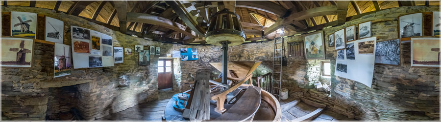
Mill Kercousquet
Click on the image to view the 360º panorama ! 
Comete Neowise 2020
Click on the image to view the 360º panorama ! 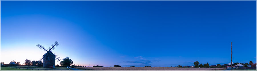
Comete Neowise 2020
Click on the image to view the 360º panorama ! 360° panoramas most viewed on this site :
Here is a selection of four panoramas taken at random among the most viewed on this site.
⤷ Click here if you want to refresh the views presented below, and discover new ones.
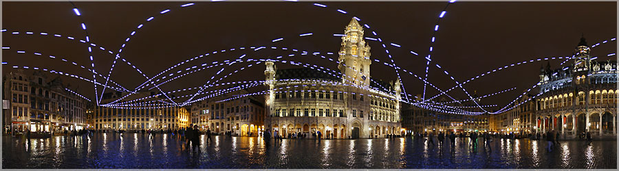

''Light sculpture designed by Yann Kersalé to the Grand Place. Whatever the direction taken to reach the Grand Place - North, South, East, West - one enters the confined space paved ground, historic facade, sky. Also enclosed you can be in this place, it inspires, it exudes tranquility, calm, perhaps the scale? Perhaps the place? Regardless, there is. Sort of grand ballroom of a castle unlikely whose ceiling is the sky, framed by richly carved facades. This is the space of sky that becomes support of convergence, starting four entities dotted lines that intertwine against the backdrop of European airspace. As many dots as ideas, passions, thoughts from the four cardinal points to speak, unite, educate, socialize... '' Yann Kersalé.
Click on the image to view the 360º panorama ! 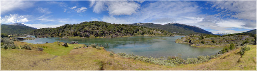
Little rest day in the Park Lapataia, located west of Ushuaia, once finished our trek.
Click on the image to view the 360º panorama ! 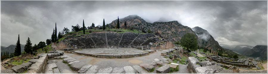
Beautiful theater of Delphi at the foot of Mount Parnassus in Phocis, Delphi is the site of a Panhellenic sanctuary, where the oracle of Apollo spoke through his prophetess, the Pythia, it also housed the omphalos or 'navel of the world'. Invested with a sacred meaning, Delphi was the sixth century BC. AD the fourth century BC. AD the true center and symbol of the unity of the Greek world.
Click on the image to view the 360º panorama ! 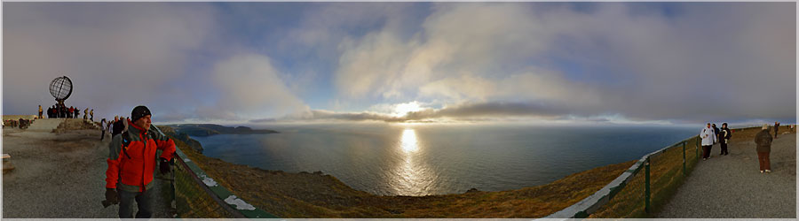
Around 23:00, the first tourists flock, and around 23:30, it is the crowd, dozens of buses spew their tourists, who have only 20-30min to take their photo, no time to enjoy the show... In any case, the driver / guide told them that the sun did not move around midnight, they saw and therefore necessarily the midnight sun. After that, if you stay too long, you will be too tired for tomorrow... Me, it's from 3:00 p.m. I'm in the same place, and I'm shoot a panorama by hours! I just moved to take the panorama above, the first of this post to be in the shadow of the sphere. Otherwise, the 24 panoramas, I chose to put me on the edge of the barrier above the sea. As usual, I sketch up panoramas, to keep a minimum of the world. In short, it was rush hour in a London subway when I took this panorama to 'FALSE' North Cape, the Northern Cape Tourism !
Click on the image to view the 360º panorama ! Panoramas 360° made by kite (KAP)
I hang my camera from a Kite, and I get it all, so I can get aerial unusual. Here is a small selection consists of three views.
⤷ Click here to view full panoramas taken with a Kite.
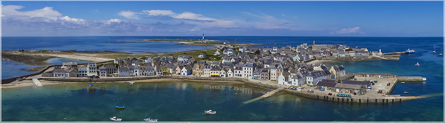
During an excursion on the island of Sein, I realized this first image above the port. The wind was very small, I even wet my line!
Click on the image to view the 360º panorama ! 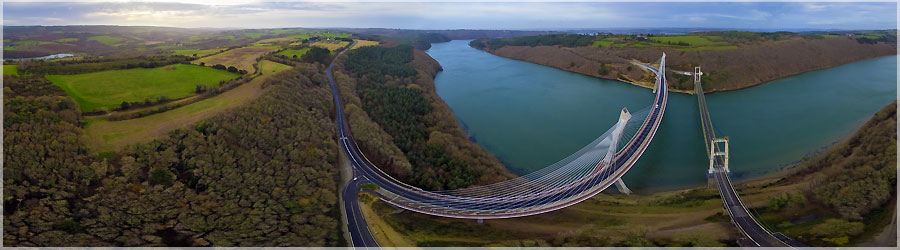
The bridge spans the Térénez Argol between Alder and Rosnoën the 791 road which connects the Crozon Faou. It is located in Brittany and is considered an essential element for opening the Crozon peninsula , if you do not want to make a detour of 47 km to go through Châteaulin to reach the North Finistère. Before the bridge , crossing the Alder was through bins to ensure the continuity of the road. Accidents were numerous , especially on fair days due to a flat-bottomed tray and maneuverable little that was swept away by the current of the tides and capsized. Alder swallowed up men, horses and goods. Bridge 1925 : The first bridge was built Térénez between 1913 and 1925. It was suspended from a length of 350 m, 272 m to the main span bridge. On 13 December 1925, he was open to traffic and has been , at the time, the largest bridge in Europe. This bridge was destroyed Térénez August 24, 1944 by the German army in order to delay the advance of the Allied troops witnesses say it was destroyed by American bombing , at the same time that they bombed the city Telgruc nearby. Bridge 1952 : The new bridge , based on its original batteries, not completed until 1952. It is a suspension bridge, like the previous one, which uses the same measurements: length 350 m, 272 m to the main span. This bridge is now suffering from " concrete cancer " ( alkaline reaction) since 1992 and is under close supervision. Bridge 2011: In 1998, the selected project towards a reconstruction of the bridge Térénez near the existing bridge. The major option is to provide access to improve traffic flow curve. On the bridge of 1951, the access right angle does not allow the crossing of a semi- trailer and another vehicle , one to give way to another. The construction began on 19 April 2007. Boxes anchor stays at the top of the pillars were respectively hoisted 7 July 2009 on the left bank ( Argol side of the peninsula ) and 13 January 2010 on the right bank ( side Rosnoën ). The first half of the structu
Click on the image to view the 360º panorama ! 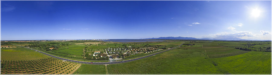
During the meeting PanoPhoto, I did a demonstration of shooting an air 360 ° panorama in kite! So I unfolded my Rokkaku kite, and I realized this aerial view. It shows the villag e of Canet en Roussillon (not to be confused with Cannet... ) Canigou and the Canet en Roussillon. It is a complete and rare ecosystem, which is classified in the European ecological network of sites of 'Natura 2000'
Click on the image to view the 360º panorama ! Panoramas 360° Unesco
During my travels, I had the opportunity to visit places registered on the
World Heritage List of UNESCO. Here is a small selection consists of three views.
⤷ Click here to view full panoramas tagged 'Unesco'.
That night in tents was very cold: it was between -13 ° C to -15 ° C. During the night, I used two water bottles (water bottles filled with hot water), one for me and one for the camera gear, batteries do not like the cold! The water in the kettle in my sleeping bag was still liquid in the morning, while the camera was a big ice cube!...
Read the full story.
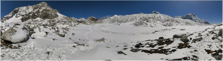
Click on the image to view the 360º panorama ! 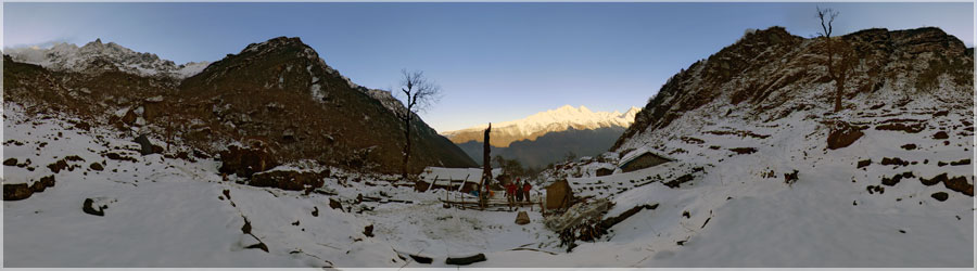
Upon awakening, after snowing all night, the weather is clear. On the one hand the Khumbu valley, on the other the rise we wait... We will climb to over 4600m this day, hard drive while we were still in 2800 24 before!...
Read the full story.
Click on the image to view the 360º panorama ! 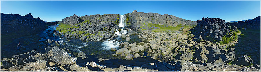
Waterfall Öxarárfoss, meaning in French "cascade Öxará", is located in the national park Thingvellir, over the course of the river Öxará. It crosses over a difference of a few meters the first part of the escarpment formed by the Almannagjá fault....
Read the full story.
Click on the image to view the 360º panorama !
|
|
|
Discover the stories of our adventures...
On the blog, you will find the stories of our adventures, decorated panoramas.
I also wrote Tutorials on using the freeware Hugin to assemble images to form panoramas!
I offer beginner tutorials, with a grip to discover step by step this software, tutorials until a fairly high level, allowing for example to practise Focus Stacking ...
|
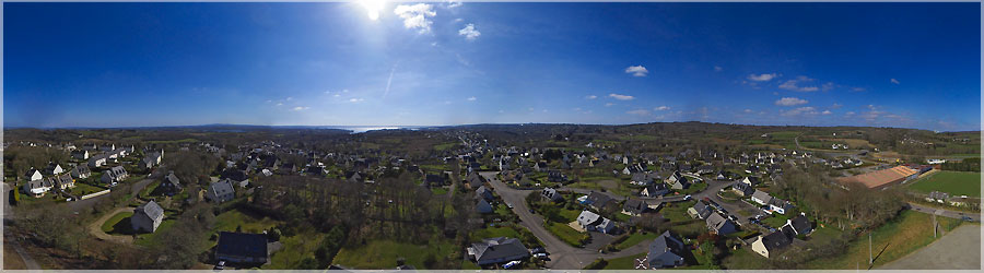
Loperhet is a town located in the Finistère department of Brittany. Surrounded by common Dirinon, Daoulas Plougastel-Daoulas Loperhet is located 9 km southwest of Landerneau and fifteen km south of Brest. The common Loperhet ends south at the tip of Tostiviec, located at the mouth of the river Daoulas. The village is located 58m but finage communal varies from 162m to sea level. The oldest document mentioning Loperhet date of 1186, this is the confirmation Hervé I de Léon (Lord Leo) instead of a donation made by his father Guyomarch IV Leo and his mother Nobilis (Nobile) canons Regulas of the abbey of Notre-Dame Daoulas. The name of the town comes from Loc Perhet, oratory Perhet ing (or Berc'hed ing, also know as St. Bridget).
Click on the image to view the 360º panorama !