SELME Matthieu Auteur photographe panoramiste 360
Home / Sphériques / Norway


play 360 panoramaCourse du Soleil pendant 24h au Cap Nord ! Je suis resté 24h au Cap Nord, et j'ai pris 24 panoramas, un chaque heure ! Cela a été ma réalisation la plus éprouvante, surtout au petit matin, quand on n'a fait qu'une nuit en pointillé... J'avais en effet apporté ma tente, et Unesco www.360x180.fr Selme Matthieu

I spent 24 hours at the North Cape, and I took 24 panoramas, one every hour ! This was my most challenging accomplishment, especially in the morning, when we made only one night dotted... I actually brought my tent, and "slept" next to the camper-car... Here is a collection of 24 panoramas, where I recovered only area including the sun, to recompose all... I was in the "wrong" North Cape, North Cape "touristy", located on the cliff 307m high. (The "real" North Cape is actually Knivskjellodden, 1.5 km to the north: I planted the tent the night after!)
   Panorama made of 24 x 3 x 12 photos taken on the 21 June 2011.  
Click on the image to view the 360º panorama !   

play 360 panoramaHurtigruten : Le Trollfjord Le Trollfjord est un bras de mer de deux kilomètres de longueur. Il sépare les deux archipels du nord de la Norvège que sont les îles Lofoten et les Vesterålen. Il est remonté par l'Hurtigruten lors de la saison estivale, entre les escales de Svolvær et de Stokmarknes, avec un seul but touristique, le fjord étant très étroit et nécessitant la réalisation d'un 'demi-tour trois temps' mais suffisamment profond pour y permettre la navigation des navires. www.360x180.fr Selme Matthieu

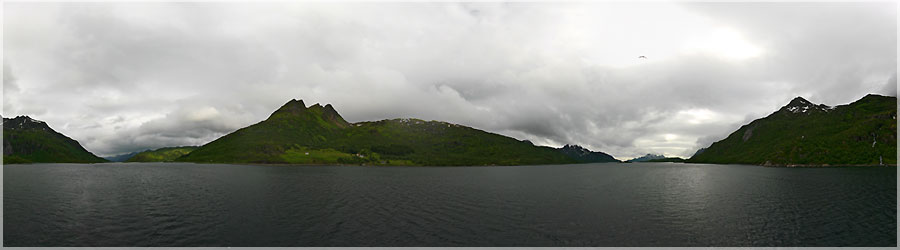
The Trollfjord is an arm of the sea two kilometers in length. It separates the two islands of northern Norway that are Lofoten and Vesterålen. It rose by Hurtigruten during the summer season, between places and Svolvær Stokmarknes with a single purpose of tourism, the fjord is very narrow and requires the completion of a 'turn around three times' but deep enough order to allow navigation of vessels.
   Panorama made of 3 x 12 photos taken on the 23 June 2011.  
Click on the image to view the 360º panorama !   

play 360 panoramaHurtigruten : entre Stokmarknes et Svolvær, sur le Raftsund La compagnie dessert aujourd'hui quotidiennement 34 ports répartis sur 2 700 km entre Bergen (sud-ouest de la Norvège) et Kirkenes (frontière russe, au-delà du cap Nord). La flotte compte onze navires modernes, combinant transport de fret, transport de passagers et croisière, qui effectuent le voyage aller-retour en onze jours. Le développement des réseaux routier et aérien a vu l'importance du trafic de marchandises décroître; les croisières ont pris le relais. Les nouveaux navires sont dignes des meilleurs navires de croisière et les officiers navigants pilotent durant la période estivale ces navires dans les fjords les plus étroits (Geirangerfjord, Trollfjord) afin de faire du Hurtigruten l'une des navigations les plus spectaculaires du Monde. Au-delà d'un simple moyen de transport, le Hurtigruten est aujourd'hui devenu une attraction touristique, connaissant un succès croissant, les voyageurs étant attirés tant par la beauté de la côte norvégienne, très découpée, que par la possibilité d'atteindre les hautes latitudes septentrionales, où l'on peut observer en été le soleil de minuit et en hiver des aurores boréales. www.360x180.fr Selme Matthieu

Today it serves daily 34 ports spread over 2700 km between Bergen (southwest Norway) and Kirkenes (Russian border, beyond the North Cape). Fleet of eleven modern ships, combining freight, passenger and cruise, which perform the round trip in eleven days. The development of road and air saw the importance of freight traffic decline; cruises took over. The new vessels are worthy of the best cruise ships crew and officers during the summer fly these ships in the fjords closer (Geirangerfjord Trollfjord) to make one of Hurtigruten's most spectacular sailing world. Beyond a simple means of transport, Hurtigruten has now become a tourist attraction, experiencing a growing success, as travelers are attracted by the beauty of the Norwegian coast, deeply indented, by the possibility of achieving high northern latitudes, where you can observe in the summer midnight sun and northern lights in winter.
   Panorama made of 3 x 12 photos taken on the 23 June 2011.  
Click on the image to view the 360º panorama !   

play 360 panoramaHurtigruten : entre Skjervøy et Tromsø  Les trois panoramas qui arrivent m'ont donné pas mal de fil à retordre pour les assembler... Ils ont été pris à main levée, sur un bâteau avançant, et de plus, pour avoir tout le paysage, il m'a fallu courir sur tout le pont pour avoir chaque point de vue !Hurtigruten est le nom du service régulier de navires qui assure la liaison entre 34 ports de la côte norvégienne depuis les années 1890.Le Hurtigruten, « la route rapide » en norvégien, traduit par express côtier en français, a été lancé en 1893 par Richard With qui quitta Trondheim en direction de Hammerfest à bord du navire à vapeur Vesteraalen. La compagnie Vesteraalens Dampskibsselskap voyait ainsi le jour. Largement aidée par des subventions du gouvernement norvégien, la ligne a longtemps été un lien vital pour de nombreux villages auxquels les navires livraient nourritures, nouvelles et matériels, et le moyen de transport dans un pays où les communications par terre sont peu aisées. La ligne a été exploitée par neuf compagnies différentes au cours de son histoire, mais un seul armateur l'exploite actuellement, Hurtigruten ASA. www.360x180.fr Selme Matthieu

Three panoramas coming gave me a lot of trouble to assemble... They were taken freehand on a boat forward, and more, for the landscape, I had run across the bridge for every point of view!Hurtigruten is the name of the regular service of ships which liaises between 34 ports of the Norwegian coast since the 1890.Le Hurtigruten, the "Quick Start" in Norwegian, translated by Coastal Express in French, was launched in 1893 by Richard With who left Trondheim towards Hammerfest aboard the steamship Vesteraalen. The company saw Vesteraalens Dampskibsselskap and day. Widely supported by grants from the Norwegian government, the line has long been a lifeline for many villages which ships delivered food, and new materials, and means of transport in a country where land communications are not easy. The line was operated by nine different companies during its history, but only the owner currently operates, Hurtigruten ASA.
   Panorama made of 3 x 12 photos taken on the 22 June 2011.  
Click on the image to view the 360º panorama !   

play 360 panoramaPanomorphing : Sommet du Nonstinden (459m) sous le Soleil 3/3 Le dernier jour, nous devons prendre le bus qui nous permettra de prendre l'Hurtigruten dans l'après-midi. Nous voulons profiter des paysages qui nous entourent car le temps est agréable. Nous décidons donc de retourner au sommet du Nonstinden et d'y apprécier la vue par temps dégagé. N'oubliez pas d'activer l'interrupteur en bas à gauche de l'écran pour faire disparaitre les nuages !  www.360x180.fr Selme Matthieu

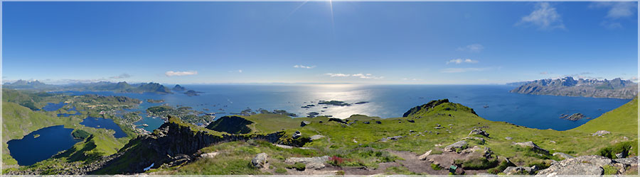
The last day, we must take the bus that will take the Hurtigruten in the afternoon. We want to enjoy the scenery around us because the weather is nice. We decide to return to the top of Nonstinden and to enjoy the view on a clear day. Do not forget to activate the switch at the bottom left of the screen to make the clouds disappear!
   Panorama made of 3 x 12 photos taken on the 03 July 2011.  
Click on the image to view the 360º panorama !   

play 360 panoramaSommet du Nonstinden (459m) sous les nuages 2/3 Lors de la même randonnée vers le sommet de Nonstinden, nous faisons une pause au bord de la falaise ! (Un énorme groupe de touristes français déjeune à proximité....) www.360x180.fr Selme Matthieu

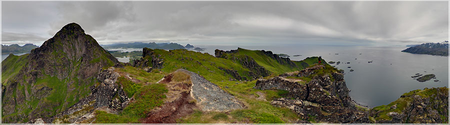
At the same hike to the summit of Nonstinden, we pause at the edge of the cliff! (A huge group of French tourists lunch nearby... .)
   Panorama made of 3 x 12 photos taken on the 01 July 2011.  
Click on the image to view the 360º panorama !   

play 360 panoramaPanomorphing : Sommet du Nonstinden (459m) sous les nuages 1/3 A Ballstad, un loueur de rorbuers accepte de nous laisser un coin de pelouse pour y planter notre tente ! Il est tout étonné de voir 2 jeunes sans voiture, avec juste la tente dans le sac à dos, dans ce village bien reculé. Nous avons accès aux douches et toilettes, et une grosse tente de réception nous sert de cuisine. Au départ de ce camping, nous ferons plusieurs randonnées dont deux fois le sommet de Nonstinden : une fois par temps gris et une fois sous le soleil ! N'oubliez pas d'activer l'interrupteur en bas à gauche de l'écran pour faire disparaitre les nuages !  www.360x180.fr Selme Matthieu

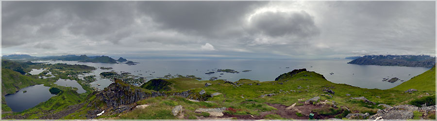
A Ballstad a rorbuers lessor agrees to leave us a piece of lawn to plant our tent! He is surprised to see two young people without a car, with just the tent in the backpack, well down in the village. We have access to showers and toilets, and a large reception tent serves as a kitchen. At the start of this site, we make several excursions including two summit Nonstinden: once cloudy and once under the sun! Do not forget to activate the switch at the bottom left of the screen to make the clouds disappear!
   Panorama made of 3 x 12 photos taken on the 01 July 2011.  
Click on the image to view the 360º panorama !   

play 360 panoramaNusfjord, port pittoresque port de pêche de l'île de Flakstadad Le village de Nusfjord est dans tous les guides touristiques, ce qui nous incite à le visiter. En effet, les bâtiments et les rorbuers de ce village pittoresque ont été rénovés. Ce village-musée est agréable à visiter : l'intérieur de certaines maisons est accessible, et meublé comme dans l'ancien temps. Dans l'une d'elle, un film y est même projeté, pour nous expliquer le quotidien des pêcheurs. Par contre, le nombre de touristes y est plus important que dans le reste des Lofoten... www.360x180.fr Selme Matthieu

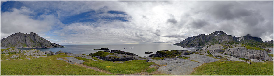
The village is Nusfjord in all tourist guides, which encourages us to visit. In fact, buildings and rorbuers of this picturesque village have been renovated. The museum village is nice to visit: inside some houses is available, furnished as in the old days. In one of them, a film is even projected to explain the daily life of fishermen. For cons, the number of tourists is more important than the rest of Lofoten...
   Panorama made of 3 x 12 photos taken on the 30 June 2011.  
Click on the image to view the 360º panorama !   

play 360 panoramaTrek de 3 jours : Moskenes 3/3 Après avoir longé les crêtes, nous apercevons sur notre gauche le lac au bord duquel nous allons dormir. Nous ne savons pas encore qu'il est infesté de moustiques et de moucherons, au point que nous serons obligés de manger dans notre tente !  www.360x180.fr Selme Matthieu

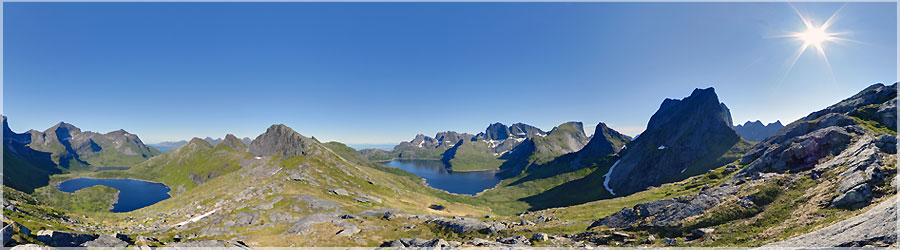
After skirting the ridges we see on our left the lake on which we sleep. We do not know yet that it is infested with mosquitoes and gnats, so that we will have to eat in our tent!
   Panorama made of 3 x 12 photos taken on the 27 June 2011.  
Click on the image to view the 360º panorama !   

play 360 panoramaTrek de 3 jours : Moskenes 2/3 Après le déjeuner, nous perdons de vue le sentier, et nous traçons tout droit dans la montagne (avec des sacs à dos chargés). Finalement, nous récupérons le sentier une fois arrivés au col Markan (412m). Cela valait le coup, la vue est splendide depuis ce col. www.360x180.fr Selme Matthieu

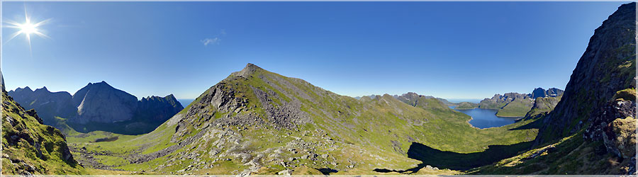
After lunch, we lose sight of the path, and we draw straight into the mountain (with loaded backpacks). Finally, we get the path once arrived at the neck Markan (412m). It was worth it, the view is beautiful from the neck.
   Panorama made of 3 x 12 photos taken on the 27 June 2011.  
Click on the image to view the 360º panorama !   

play 360 panoramaTrek de 3 jours : Moskenes 1/3 Arrivés au bout du fjord, au village de Kjerkfjorden, nous entamons une pente raide, et nous arrivons à un col. Nous pouvons alors voir la mer des deux côtés ! Nous voyons au loin la plage de sable blancs Horseidvika, vers laquelle nous nous dirigeons, pour y déjeuner. www.360x180.fr Selme Matthieu

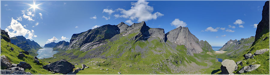
Reached the end of the fjord village of Kjerkfjorden, we begin a steep slope, and we arrive at a pass. Then we can see the sea on both sides! We see in the distance the white sandy beach Horseidvika towards which we are heading for lunch.
   Panorama made of 3 x 12 photos taken on the 27 June 2011.  
Click on the image to view the 360º panorama !   

play 360 panoramaPetit port de Reine De Moskenes, nous prenons le bus jusqu'à Reine, puis le bateau au départ de Reine jusqu'au bout du fjord, au village de Kjerkfjorden. Cette petite balade en bateau est assez agréable et nous permet de découvrir les paysages sous un autre point de vue.  Nous avons en tête de faire un trek de 3 jours : le premier jour, après le bateau, nous marcherons jusqu'à la plage de Horseidvika, puis nous nous dirigerons vers l'est, où nous franchirons le col de Markan (412m), pour dormir près du lac de Fageravatnet. Le second jour, nous poursuivrons le sentier jusqu'à une petite route à Selfjord. Nous récupèrerons ensuite le sentier à Marka, pour dormir sur la plage de Kvalvika. Le troisième jour, nous rejoindrons Fredvang, pour y prendre le bus à destination de Leknes. www.360x180.fr Selme Matthieu

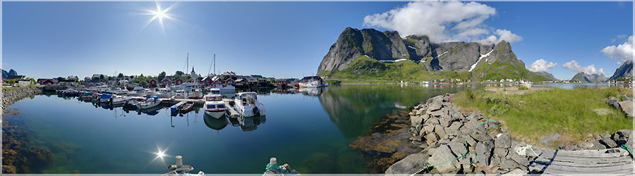
Moskenes, we take the bus to Queen, then the boat from Reine to the end of the fjord village of Kjerkfjorden. This little boat ride is quite nice and allows us to discover the landscape from a different perspective. We have in mind to do a trek of three days: the first day after the boat, we walk to the beach Horseidvika, then we head east, where we cross the neck of Markan (412m) sleeping near Lake Fageravatnet. The second day, we will continue the path until a small road Selfjord. Then we recover the trail Marka, sleeping on the beach Kvalvika. The third day, we reach Fredvang, to take the bus to Leknes.
   Panorama made of 3 x 12 photos taken on the 27 June 2011.  
Click on the image to view the 360º panorama !   

play 360 panoramaRandonnée au départ de Moskenes 4/4 Le temps est tellement beau que nous en profitons pour aller jusqu'à Å, et y faire quelques courses. Il n'y a pas d'alimentation à Moskenes ! www.360x180.fr Selme Matthieu

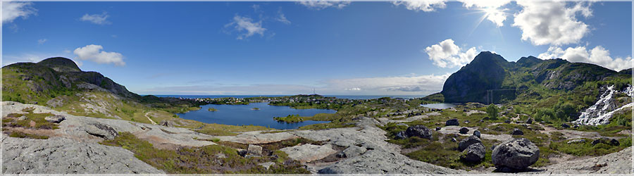
The weather is so beautiful that we take the opportunity to go to Å, and do some shopping there. There is no power in Moskenes!
   Panorama made of 3 x 12 photos taken on the 26 June 2011.  
Click on the image to view the 360º panorama !   

play 360 panoramaRandonnée au départ de Moskenes 3/4 Nous prenons le temps de profiter de cette magnifique journée avec des paysages très dépaysants. www.360x180.fr Selme Matthieu

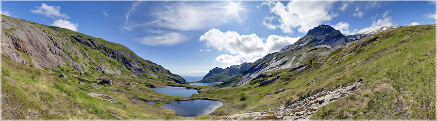
We take the time to enjoy this beautiful day with very scenic in landscapes.
   Panorama made of 3 x 12 photos taken on the 26 June 2011.  
Click on the image to view the 360º panorama !   

play 360 panoramaRandonnée au départ de Moskenes 2/4 Cette randonnée se caractérise par de très nombreux lacs, et la prédominance de l'eau dans les paysages. Le lac le plus bas sert de réserve d'eau potable pour le village de Moskenes, la baignade y est donc interdite. Le chemin est assez escarpé. www.360x180.fr Selme Matthieu

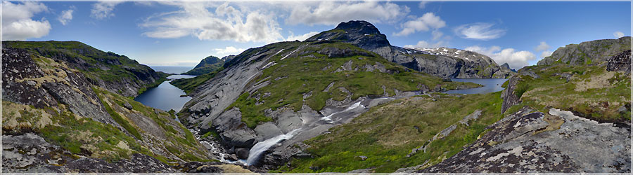
This hike is characterized by numerous lakes, and the predominance of water in the landscape. The lake serves as the lower reservoir of drinking water for the village of Moskenes, swimming is prohibited. The path is fairly steep.
   Panorama made of 3 x 12 photos taken on the 26 June 2011.  
Click on the image to view the 360º panorama !   

play 360 panoramaRandonnée au départ de Moskenes 1/4 Juste à côté de Å se trouve un autre petit village où le camping est ouvert ! Il se situe à Moskenes, à côté de l'embarcadère. Les douches sont chaudes, et il y a une cuisine abritée, qui permet de se réchauffer, ainsi qu'une machine à laver le linge AVEC un sèche linge : le luxe ! Le temps s'améliore, le ciel se dégage, nous en profitons pour faire une magnifique randonnée au départ de ce camping. www.360x180.fr Selme Matthieu

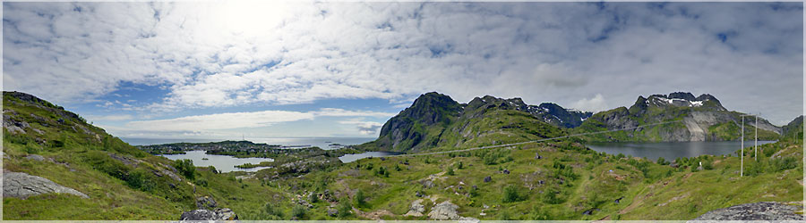
Next to Å is another small village where the campsite is open! It is located Moskenes next to the pier. The showers are hot, and there is a kitchen shelter, which allows warm, and a washing machine dryer : luxury! The weather improves, the sky clears, we enjoy a beautiful hike to the start of this site.
   Panorama made of 3 x 12 photos taken on the 26 June 2011.  
Click on the image to view the 360º panorama !   

play 360 panoramaRandonnée au départ de Å Aujourd'hui, nous décidons de faire notre première randonnée dans les Lofoten. Nous longeons le lac de Å, pour nous diriger vers le Nord-Ouest, afin de traverser l'île. Nous nous arrêterons au col, à cause des mauvaises conditions météos. Du col, nous voyons la mer de chaque côté de l'île. www.360x180.fr Selme Matthieu

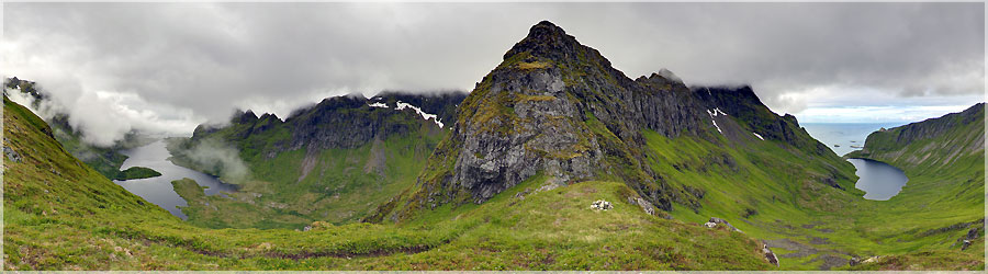
Today, we decided to do our first hike in Lofoten. We skirt Lake Å, and go towards the northwest to cross the island. We stop at the neck, due to bad weather. Neck, we see the sea on both sides of the island.
   Panorama made of 3 x 12 photos taken on the 25 June 2011.  
Click on the image to view the 360º panorama !   

play 360 panoramaVue des hauteurs de Å Nous nous installons donc sur les hauteurs de Å. Voici la vue lors de notre réveil ! Le village de Å est un petit village de pêcheurs où il fait bon flâner. Tout autour du village, des séchoirs à poissons (des Tørrfisk)  parfument les environs... www.360x180.fr Selme Matthieu

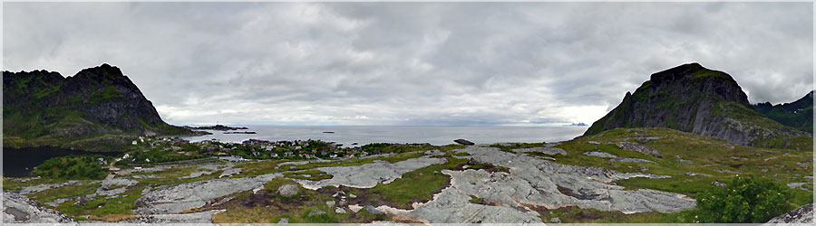
So we settled on the heights of Å. Here is the view when we woke up! The village of Å is a small fishing village where you can stroll. Around the village, dryers fish: Tørrfisk perfume around...
   Panorama made of 3 x 12 photos taken on the 24 June 2011.  
Click on the image to view the 360º panorama !   

play 360 panoramaVue à partir du village de Å Après notre première nuit de camping sauvage à Stamsund, nous prenons un premier bus jusqu'à Leknes, puis un deuxième jusqu'au village de Å. A Å, nous sommes déçus car le camping est fermé ! Nous sommes donc obligés d'envisager une deuxième nuit de camping sauvage. En fait, nous aurions aimé pouvoir nous laver, mais peu importe, car la vue d'ici compense le manque de confort.  www.360x180.fr Selme Matthieu

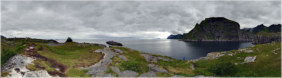
After our first night of camping in Stamsund, we take a bus to Leknes first and a second to the village of Å. A Å, we are disappointed because the campsite is closed! We are therefore forced to consider a second night of camping. In fact, we would have liked to wash, but no matter, because here compensates for the lack of comfort.
   Panorama made of 3 x 12 photos taken on the 24 June 2011.  
Click on the image to view the 360º panorama !   

play 360 panoramaHurtigruten : l'avant du bâteau Notre trajet sur ce bâteau durera environ 36h, pour ralier Honningsvåg à Stamsund. Tous les moyens sont bons pour nous dégourdir les jambes, et nous divertir ! Nous faisons donc une petite promenade sur le pont. Quand nous arrivons enfin à destination, nous cherchons un terrain pour planter notre tente... C'est notre première nuit de camping sauvage, et nous ne savons pas vraiment où nous installer. www.360x180.fr Selme Matthieu

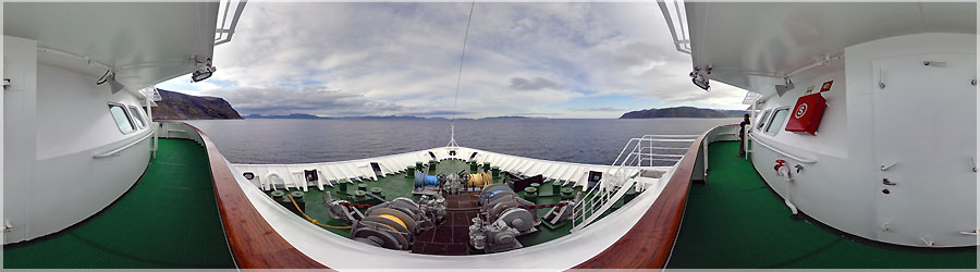
Our journey on this boat will take about 36 hours for ralier Honningsvåg Stamsund. All means are good to stretch our legs, and entertain us! We then a walk on the bridge. When we finally arrived at destination, we are looking for land to pitch our tent... This is our first night of camping, and we do not really know where we install.
   Panorama made of 3 x 12 photos taken on the 22 June 2011.  
Click on the image to view the 360º panorama !   

play 360 panoramaHurtigruten : La salle panoramique Tôt le matin, nous prenons le fameux bâteau de croisière, de la compagnie Hurtigrüten, au départ de Honningsvåg. Le bâteau est désert, les passagers dorment confortablement en cabine... Nous nous installons alors sur les fauteils de la 'Salle Panoramique'. www.360x180.fr Selme Matthieu

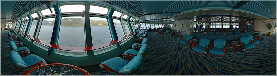
Early morning we take the famous boat cruise company Hurtigruten, departing from Honningsvåg. The boat was deserted passengers sleep comfortably in the cabin... Then we sit on the armchairs, in the 'Panoramic Room '
   Panorama made of 3 x 12 photos taken on the 22 June 2011.  
Click on the image to view the 360º panorama !   

play 360 panoramaSoleil de Minuit au Vrai Cap Nord ! Nous sommes retournés à notre tente, nous avons bien mangé, et le soir, avant de se coucher, nous sommes allés admirer le soleil de minuit au Vrai Cap Nord... www.360x180.fr Selme MatthieuUnesco www.360x180.fr Selme Matthieu

We returned to our tent, we ate well, and in the evening before going to bed, we went to see the midnight sun at the North Cape True...
   Panorama made of 3 x 12 photos taken on the 20 June 2011.  
Click on the image to view the 360º panorama !   

play 360 panoramaVrai Cap Nord à 18h00 Au bout de 24h passées au Cap Nord Touristique, nous prennons nos sacs à dos, pour aller camper cette fois au Vrai Cap Nord ! Un petite randonnée de quelques heures, et nous voici à contempler ce magnifique paysage... On remarque sur la droite la haute falaise, où nous étions la nuit précédente... www.360x180.fr Selme MatthieuUnesco www.360x180.fr Selme Matthieu

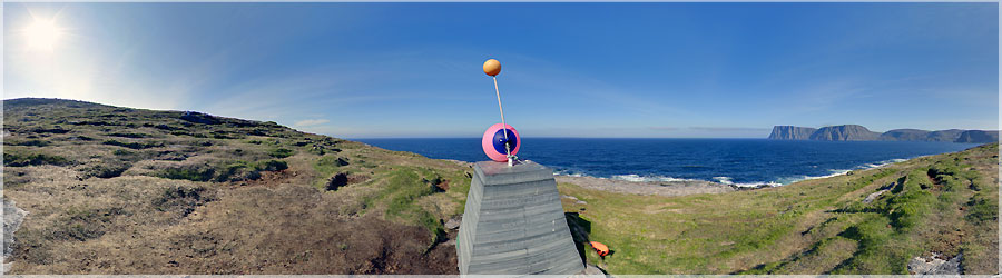
After 24 hours past the North Cape Travel, we take our bags to go camping this time at True North Cape! A short hike of a few hours, and here we are contemplating this beautiful landscape... We see on the right the cliff, where we were the night before...
   Panorama made of 3 x 12 photos taken on the 19 June 2011.  
Click on the image to view the 360º panorama !   

play 360 panoramaSoleil de Minuit au Cap Nord Touristique Vers 23h00, les premiers touristes affluent, et vers 23h30, c'est la cohue, des bus par dizaines crachent leurs touristes, qui n'ont que 20-30min pour prendre leur photo, pas le temps d'apprécier le spectacle... De toutes les façons, le chauffeur / guide leur a dit que le soleil ne bougeait plus vers minuit, et qu'ils voyaient donc forcément le soleil de minuit. Après, si on reste trop longtemps, on va être trop fatigué pour la journée de demain... Moi, ça fait depuis 15h00 que je suis au même endroit, et que je prends un panorama pas heure ! Je me suis juste déplacé pour prendre le panorama précédent pour être dans l'ombre de la sphère. Sinon, pour les 24 panoramas, j'ai choisi de me mettre au bord de la barrière, au dessus de la mer. Comme à mon habitude, j'épure au maximum les panoramas, pour ne garder qu'un minimum de monde. Bref, c'était l'heure de pointe dans un métro parisien quand j'ai pris ce panorama au 'FAUX' Cap Nord , le Cap Nord Touristique !  www.360x180.fr Selme MatthieuUnesco www.360x180.fr Selme Matthieu

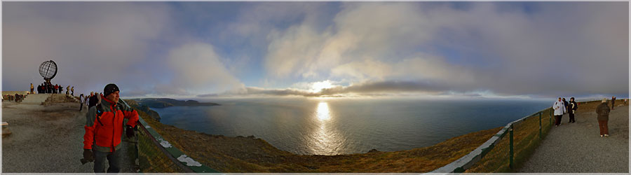
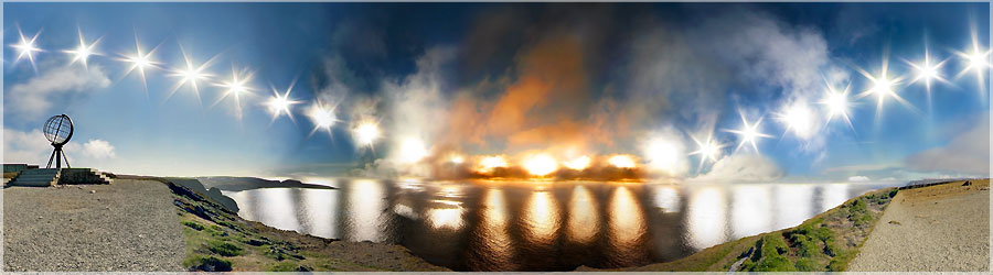
Around 23:00, the first tourists flock, and around 23:30, it is the crowd, dozens of buses spew their tourists, who have only 20-30min to take their photo, no time to enjoy the show... In any case, the driver / guide told them that the sun did not move around midnight, they saw and therefore necessarily the midnight sun. After that, if you stay too long, you will be too tired for tomorrow... Me, it's from 3:00 p.m. I'm in the same place, and I'm shoot a panorama by hours! I just moved to take the panorama above, the first of this post to be in the shadow of the sphere. Otherwise, the 24 panoramas, I chose to put me on the edge of the barrier above the sea. As usual, I sketch up panoramas, to keep a minimum of the world. In short, it was rush hour in a London subway when I took this panorama to 'FALSE' North Cape, the Northern Cape Tourism !
   Panorama made of 3 x 12 photos taken on the 18 June 2011.  
Click on the image to view the 360º panorama !   

play 360 panoramaCap Nord Touristique à 17h00 Le Cap Nord Toursitique (en norvégien Nordkapp), est caractéristique par sa grande falaise de 307m se jetant dans la mer, et cette sculpture du globe terrestre. Il n'y a pas encore de monde vers 17h00, les bus afflueront vers 23h00 pour contempler le soleil de minuit. Cette falaise est souvent décrite comme le point le plus septentrional d'Europe, bien que cette situation corresponde en réalité au Knivskjellodden voisin, 1,5 kilomètre plus au nord. www.360x180.fr Selme MatthieuUnesco www.360x180.fr Selme Matthieu

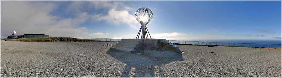
North Cape travel gear (in Norwegian Nordkapp) is characteristic by its high cliff 307m flowinf into the sea, and the sculpture of the globe. There is no world yet to 17:00, 23/00 to bus flock to watch the midnight sun. This cliff is often described as the northernmost point of Europe, although this corresponds in reality Knivskjellodden neighbor, 1.5km to the north.
   Panorama made of 3 x 12 photos taken on the 18 June 2011.  
Click on the image to view the 360º panorama !   

play 360 panoramaMoteur du bâteau 'Le Fram'  Il y a 115 ans, le 24 juin 1893, le Norvégien Fridtjof Nansen et ses compagnons quittaient Oslo à bord du navire le Fram, pour ce que la société Royale Géographique de Londres considérait alors comme le projet le plus dangereux jamais conçu : une dérive à travers l'Océan Arctique. L'existence d'un courant polaire et imaginer qu'un navire puisse résister à la pression des glaces, relevait de l'utopie pour beaucoup. Le Fram est un navire qui fut utilisé pour l'exploration polaire successivement par les explorateurs norvégiens Fridtjof Nansen, Otto Sverdrup et Roald Amundsen entre 1893 et 1912. C'est une goélette à trois mâts de 39 mètres de long et de 11 mètres de large, conçue par l'architecte naval norvégien Colin Archer en prévision de l'expédition de Nansen, au cours de laquelle elle devait se laisser prendre par la banquise afin de dériver par dessus le pôle Nord. L'expedition a réussi à se faire prendre dans les glaces, et en est ressortie 3 ans plus tard. Le Fram est maintenant exposé et conservé à Oslo dans un musée qui lui est dédié, le Frammuseet. Cette aventure est à mettre en parallèle avec une autre expédition, achevée fin Janvier 2008, le Tara. L'expédition 'Tara Artic' avait pour projet de se faire prendre aussi dans les glaces, afin d'étudier la dérive des glaces. Le bateau est allé plus au pôle Nord que l'ancienne expédition, et n'est resté emprisonné des glaces 'que' 1an et demi...  A chacun d'en tirer les conclusions qu'il souhaitera... www.360x180.fr Selme Matthieu

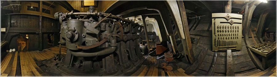
115 years ago, June 24, 1893, the Norwegian Fridtjof Nansen and his companions left Oslo on board the Fram, to what the Royal Geographical Society of London then considered the draft's most dangerous ever conceived: a drift through the Arctic Ocean. The existence of a polar current and imagine that a ship can withstand ice pressure, was utopian to many. The Fram is a ship that was used to polar exploration in succession by the Norwegian explorer Fridtjof Nansen, Otto Sverdrup and Roald Amundsen between 1893 and 1912. It is a three-masted schooner of 39 meters long and 11 meters wide, designed by Norwegian naval architect Colin Archer in anticipation of the Nansen expedition, during which she was to be caught by the pack to drift over the North Pole. The expedition managed to get caught in the ice, and came out three years later. The Fram is now on display in Oslo and kept in a museum dedicated to him, the Frammuseet. This adventure is to be compared with another expedition, completed in late January 2008 the Tara. The expedition 'Tara Arctic' project was also being caught in the ice to study the ice drift. The boat went over the North Pole than the previous expedition, and has remained imprisoned ice 'only' 1 year and a half... At each draw conclusions that wish...
   Panorama made of 12 photos taken on the 11 August 2008.  
Click on the image to view the 360º panorama !   

play 360 panoramaHabitat traditionnel : ancienne pharmacie Ancienne pharmacie entièrement rénovée. Admirez les flacons délicatement disposés sur les étagères... www.360x180.fr Selme Matthieu

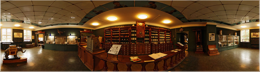
Renovated old pharmacy. Admire the delicately arranged bottles on the shelves...
   Panorama made of 13 photos taken on the 10 August 2008.  
Click on the image to view the 360º panorama !   

play 360 panoramaHabitat traditionnel, toiture végétale Le principe de la toiture végétale existe vraisemblablement depuis le néolitique (-12500 à -8000 av. JC). Il consiste à recouvrir d'un substrat végétalisé un toit plat ou à faible pente. De nombreuses expériences conduites en Europe ont montré que pour des objectifs esthétiques ou de durabilité, l'aménagement d'un 'écotoit' se révélait intéressant. www.360x180.fr Selme Matthieu

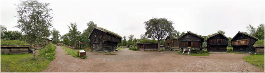
The principle of the green roof is expected since the Neolithic (-12,500 to -8000 BC. JC). It consists of a substrate to cover a flat roof or vegetated low slope. Many experiments conducted in Europe have shown that for aesthetic objectives or sustainability, the development of a 'écotoit' proved interesting.
   Panorama made of 11 photos taken on the 10 August 2008.  
Click on the image to view the 360º panorama !   

play 360 panoramaTroll du Tremplin olympique Le Troll en granit surveille les sportifs, au pied du tremplin olympique... www.360x180.fr Selme Matthieu

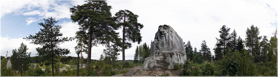
The Troll granite monitors athletes at the foot of the Olympic springboard...
   Panorama made of 12 photos taken on the 09 August 2008.  
Click on the image to view the 360º panorama !   

play 360 panoramaTremplin Olympique La capitale norvégienne a déjà  reçu l'événement en 1952 où le saut à ski avait connu un énorme succès avec plus de 150.000 spectateurs sur la colline d'Holmenkollen. Depuis, cette colline est devenue le temple du ski nordique; les Coupes du Monde de ski de fond, saut à ski, combiné nordique et biathlon y font d'ailleurs étape chaque année. www.360x180.fr Selme Matthieu

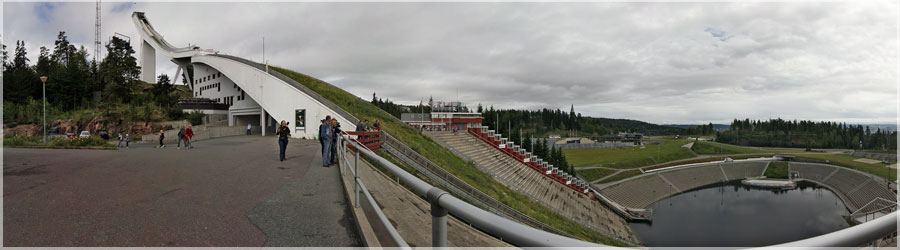
The Norwegian capital has already received the event in 1952 where ski jumping was a huge success with more than 150,000 spectators on the hill at Holmenkollen. Since then, Hill has become the temple of Nordic skiing, the World Cup cross-country skiing, ski jumping, Nordic combined and biathlon there are also step each year.
   Panorama made of 12 photos taken on the 09 August 2008.  
Click on the image to view the 360º panorama !   

play 360 panoramaPont Vigeland Sur le Pont de 100 mètres de long, Vigeland a placé 58 sculptures de bronze : des hommes, des femmes et des enfants, dont l'un des plus populaires du parc : L'enfant en colère. www.360x180.fr Selme Matthieu

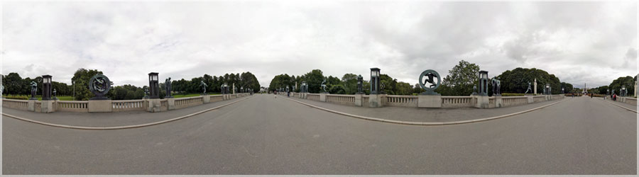
On the bridge 100 meters long, placed 58 Vigeland sculptures in bronze: men, women and children, one of the most popular park: The angry child.
   Panorama made of 14 photos taken on the 08 August 2008.  
Click on the image to view the 360º panorama !   

play 360 panoramaCadran Solaire Vigeland En 1921, le conseil municipal d'Oslo décide de détruire le vieil édifice où se trouvait l'atelier du sculpteur pour construire une bibliothèque. Arrivé à un accord, le conseil construira un nouvel édifice servant d'atelier et de maison pour Vigeland qui sera à sa mort changé en musée. En échange, Vigeland s'engage à offrir à la ville tout son travail, ses sculptures, ses dessins, ses bas-reliefs et ses modèles. www.360x180.fr Selme Matthieu

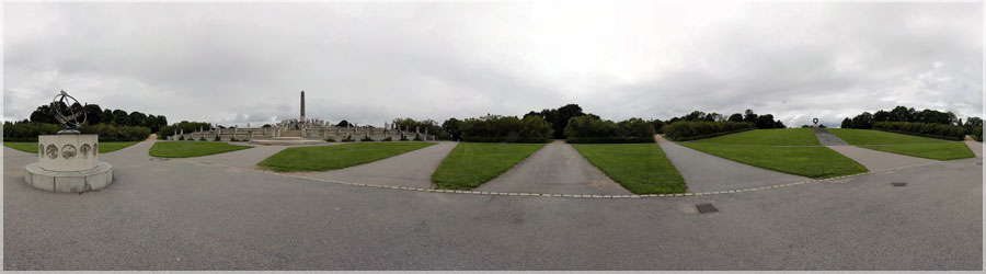
In 1921, the Oslo City Council decides to destroy the old building which was the workshop of the sculptor to build a library. Reached an agreement, the council will construct a new building serving as a workshop and will be home to Vigeland his death changed into a museum. In return, Vigeland committed to providing the city all his work, sculptures, drawings, reliefs and models.
   Panorama made of 10 photos taken on the 08 August 2008.  
Click on the image to view the 360º panorama !   

play 360 panoramaPlace Radhus La place Radhus est la place de l'hôtel de ville. C'est ici que commence la rue Stroget, la rue marchande de la ville. www.360x180.fr Selme Matthieu

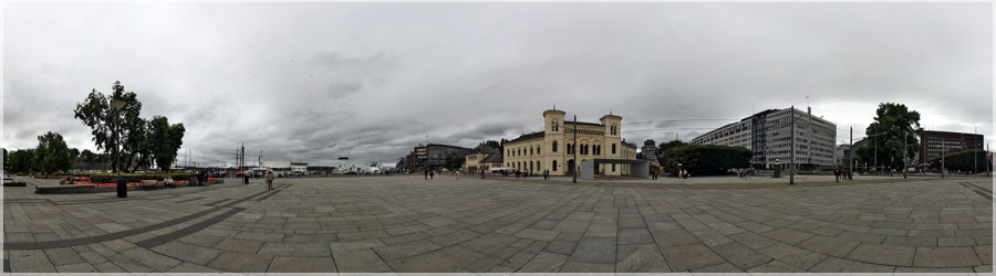
Instead Radhus is the place of the town hall. Here begins the street Strà¸get, the shopping street of the city.
   Panorama made of 14 photos taken on the 08 August 2008.  
Click on the image to view the 360º panorama !   

play 360 panoramaParc et plateau de Vigeland Les sculptures de Vigeland sont en granit ou en bronze : il a utilisé un magnifique granite à grain fin, originaire de Norvège. Dans sa maison à Kirkeveien, il vécut et travailla jusqu'à  sa mort en 1943. Ses cendres y reposent et sont conservées dans la tour. Comme prévu, l'édifice fut transformé en Musée Vigeland, où l'on peut trouver divers oeuvres de l'artiste et tous les modèles originaux des sculptures de Frognerparken. www.360x180.fr Selme Matthieu

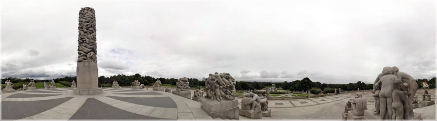
The Vigeland Sculpture are granite or bronze: he used a beautiful grained granite from Norway. In his house in Kirkeveien, he lived and worked until his death in 1943. His ashes are buried and are stored in the tower. As expected, the building was transformed into Vigeland Museum, where you can find various works of the artist and all the original models of sculptures Frognerparken.
   Panorama made of 27 photos taken on the 08 August 2008.  
Click on the image to view the 360º panorama !   

play 360 panoramaPalais Royal d'Oslo Le palais royal d'Oslo est la résidence officielle de la famille royale de Norvège. Il fut construit sur la colline Slottsbakken durant la première moitié du XIXe siècle. Tous les 17 mai, à l'occasion de la fête nationale norvégienne, le roi et le reste de la famille royale apparaissent au balcon principal. www.360x180.fr Selme Matthieu

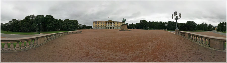
The Royal Palace in Oslo is the official residence of the royal family of Norway. It was built on the hill Slottsbakken in the first half of the nineteenth century. All May 17th, at the Norwegian national day, the king and the rest of the royal family appear in the main balcony.
   Panorama made of 20 photos taken on the 08 August 2008.  
Click on the image to view the 360º panorama !   


Retour en haut