

Panorama made of 7 photos taken on the 12 August 2013.
Click on the image to view the 360º panorama ! 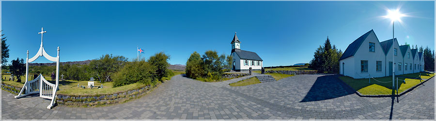
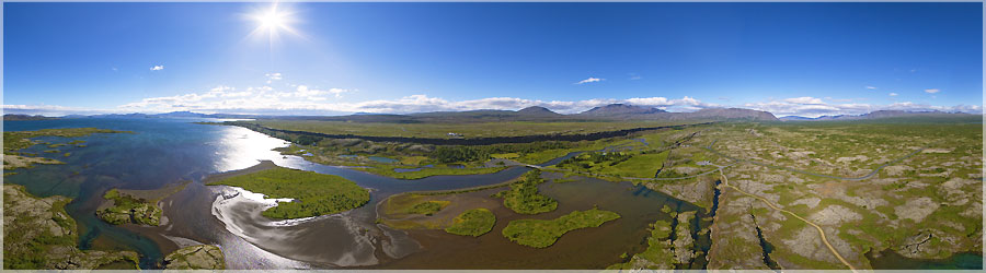
Panorama made of 13 x 3 photos taken on the 12 August 2013.
Click on the image to view the 360º panorama ! 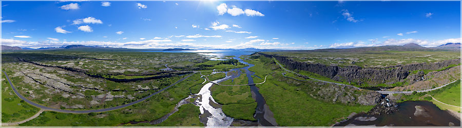
Panorama made of 6 photos taken on the 12 August 2013.
Click on the image to view the 360º panorama ! 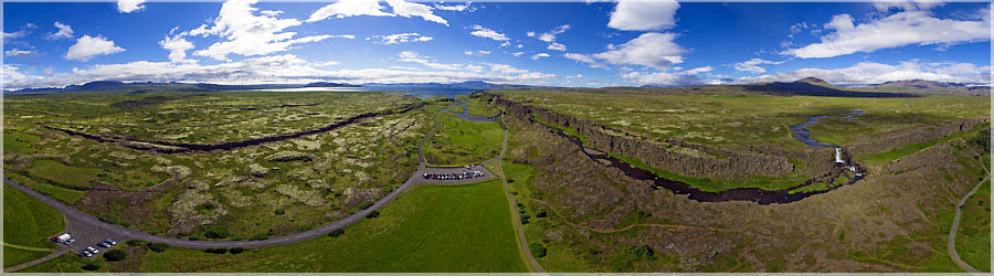
This year, I refined my technique of aerial photography, and as there is wind, I very much fun!...
Read the full story. Panorama made of 6 photos taken on the 12 August 2013.
Click on the image to view the 360º panorama ! 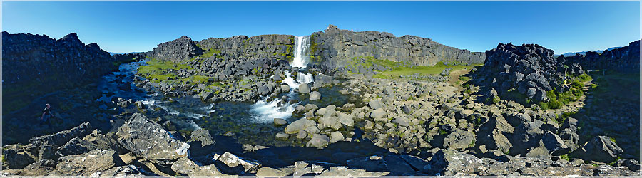
Waterfall Öxarárfoss, meaning in French "cascade Öxará", is located in the national park Thingvellir, over the course of the river Öxará. It crosses over a difference of a few meters the first part of the escarpment formed by the Almannagjá fault....
Read the full story. Panorama made of 13 x 3 photos taken on the 12 August 2013.
Click on the image to view the 360º panorama ! 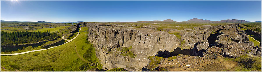
Before accessing the cascade of Oxararfoss, we climb the fault, in order to have an overview of landslides. This is awesome!...
Read the full story. Panorama made of 13 x 3 photos taken on the 12 August 2013.
Click on the image to view the 360º panorama ! 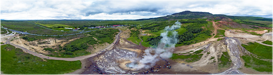
Panorama made of 6 photos taken on the 11 August 2013.
Click on the image to view the 360º panorama ! 
Panorama made of 7 photos taken on the 07 August 2013.
Click on the image to view the 360º panorama ! 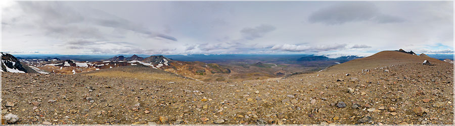
Panorama made of 13 x 3 photos taken on the 07 August 2013.
Click on the image to view the 360º panorama ! 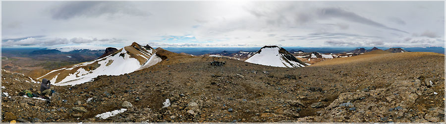
Panorama made of 13 x 3 photos taken on the 07 August 2013.
Click on the image to view the 360º panorama ! 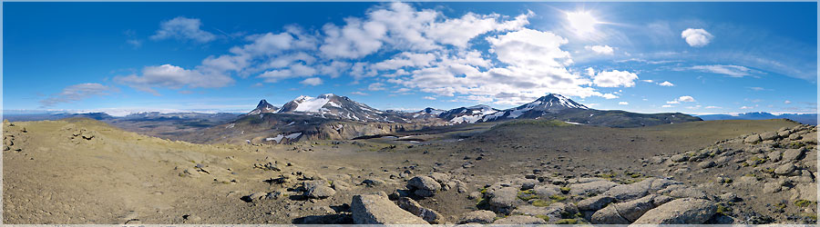
Panorama made of 13 x 3 photos taken on the 07 August 2013.
Click on the image to view the 360º panorama ! 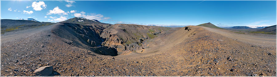
Panorama made of 13 x 3 photos taken on the 06 August 2013.
Click on the image to view the 360º panorama ! 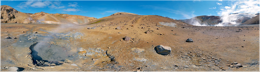
Panorama made of 13 x 3 photos taken on the 06 August 2013.
Click on the image to view the 360º panorama ! 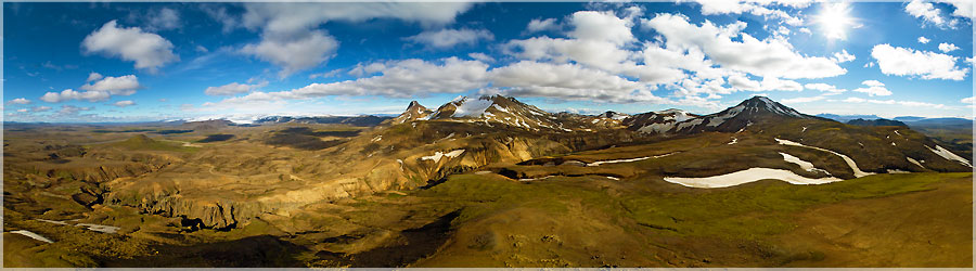
Panorama made of 7 photos taken on the 06 August 2013.
Click on the image to view the 360º panorama ! 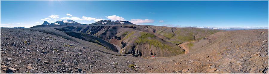
Panorama made of 13 x 3 photos taken on the 06 August 2013.
Click on the image to view the 360º panorama ! 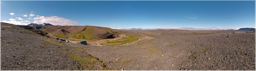
Panorama made of 13 x 3 photos taken on the 06 August 2013.
Click on the image to view the 360º panorama ! 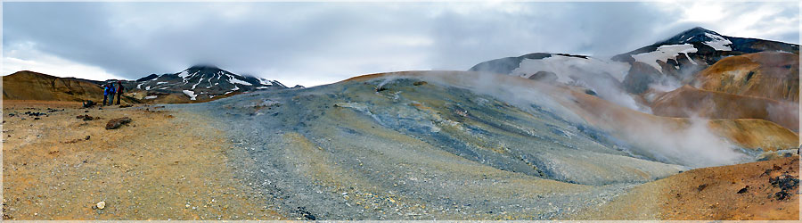
Panorama made of 13 x 3 photos taken on the 06 August 2013.
Click on the image to view the 360º panorama ! 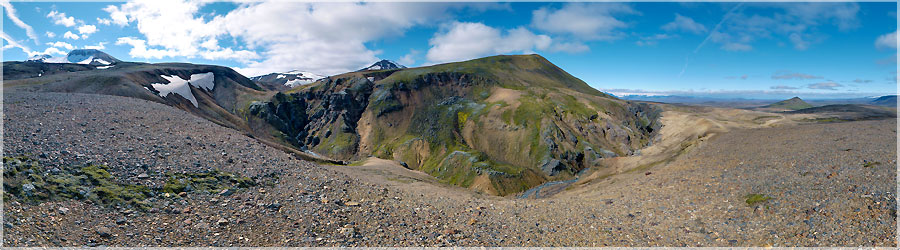
Panorama made of 13 x 3 photos taken on the 06 August 2013.
Click on the image to view the 360º panorama ! 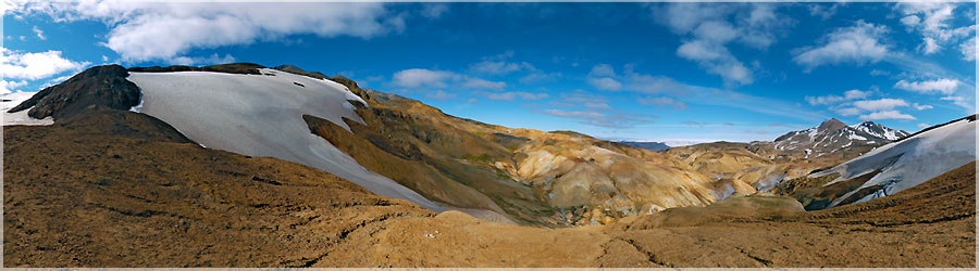
Panorama made of 13 x 3 photos taken on the 05 August 2013.
Click on the image to view the 360º panorama ! 
Panorama made of 13 x 3 photos taken on the 05 August 2013.
Click on the image to view the 360º panorama ! 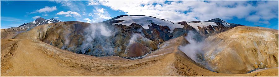
Panorama made of 13 x 3 photos taken on the 04 August 2013.
Click on the image to view the 360º panorama ! 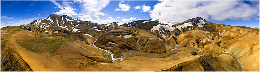
Panorama made of 7 photos taken on the 04 August 2013.
Click on the image to view the 360º panorama ! 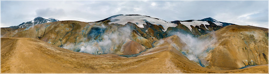
Panorama made of 13 x 3 photos taken on the 04 August 2013.
Click on the image to view the 360º panorama ! 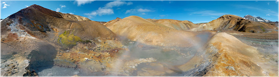
Panorama made of 13 x 3 photos taken on the 04 August 2013.
Click on the image to view the 360º panorama ! 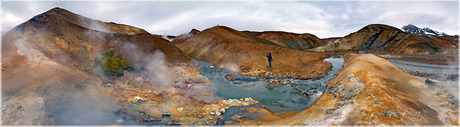
Panorama made of 13 x 3 photos taken on the 04 August 2013.
Click on the image to view the 360º panorama ! 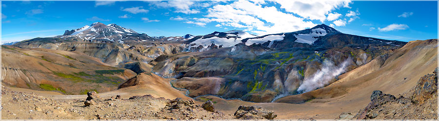
Panorama made of 13 x 3 photos taken on the 03 August 2013.
Click on the image to view the 360º panorama ! 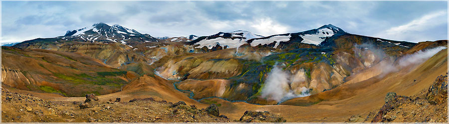
Panorama made of 13 x 3 photos taken on the 03 August 2013.
Click on the image to view the 360º panorama ! 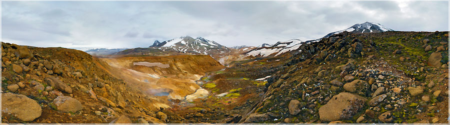
Panorama made of 13 x 3 photos taken on the 03 August 2013.
Click on the image to view the 360º panorama ! 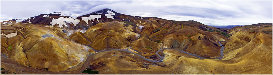
Panorama made of 7 photos taken on the 03 August 2013.
Click on the image to view the 360º panorama ! 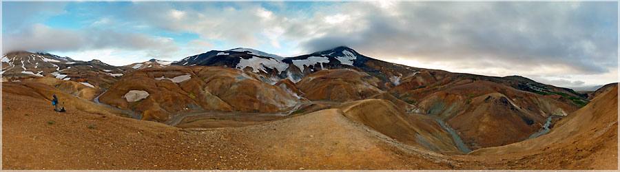
Panorama made of 13 x 3 photos taken on the 03 August 2013.
Click on the image to view the 360º panorama ! 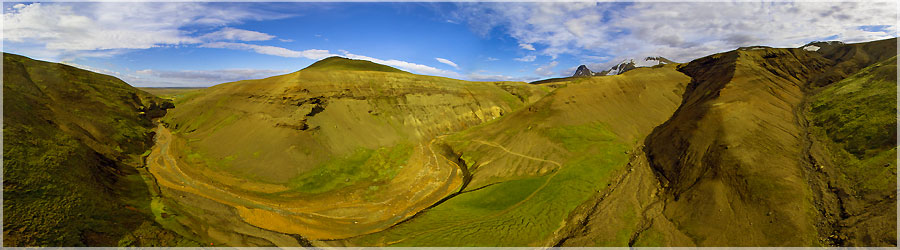
Panorama made of 7 photos taken on the 03 August 2013.
Click on the image to view the 360º panorama ! 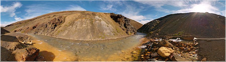
Panorama made of 13 x 3 photos taken on the 03 August 2013.
Click on the image to view the 360º panorama ! 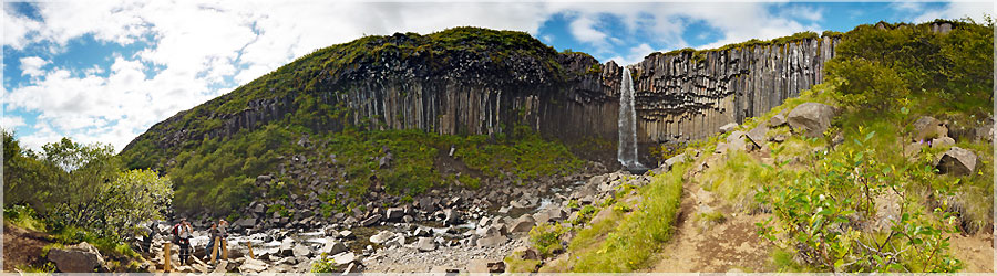
Panorama made of 13 x 3 photos taken on the 02 August 2013.
Click on the image to view the 360º panorama ! 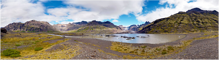
We go out for a walk anyway, and go round the whole mountain to see another lake and glacier. The noise is terrible, we believe that there is a storm nearby, but no, in fact it is the seracs that collapse in a huge crash in the distance in the valley....
Read the full story. Panorama made of 13 x 3 photos taken on the 02 August 2013.
Click on the image to view the 360º panorama ! 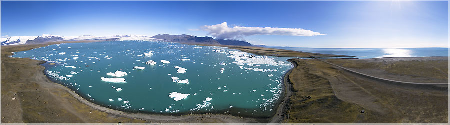
Matthieu launches his kite and performs two panoramic views: one at ground level, and even a hundred meters above....
Read the full story. Panorama made of 7 photos taken on the 01 August 2013.
Click on the image to view the 360º panorama ! 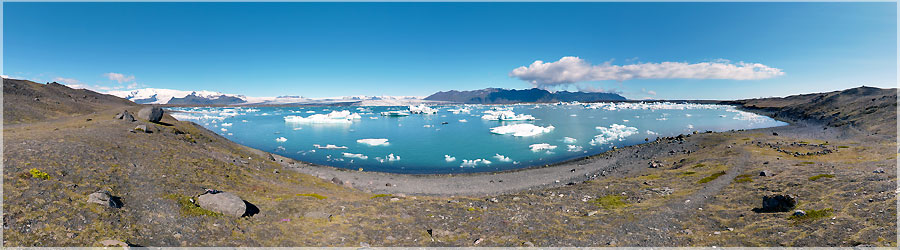
Matthieu launches his kite and performs two panoramic views: one at ground level, and even a hundred meters above....
Read the full story. Panorama made of 13 x 3 photos taken on the 01 August 2013.
Click on the image to view the 360º panorama ! 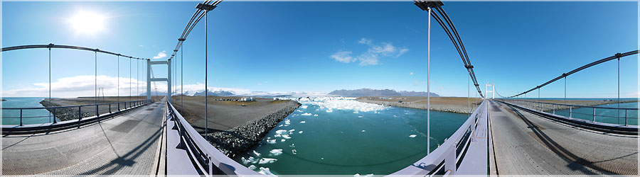
The flow of large ice from the lake to the sea takes place depending on the tides. Indeed, at high tide, all the ice cubes are stuck in the lake, and the difference between freshwater (glacial melt) we perceive very well and seawater This creates a kind of "barage" and ice can not get out! By cons, once the tide begins to fall, there comes a time when the lake water is a little fuller, the forces are reversed, and all ice near the mouth escape! This phenomenon is visible with the pano-morphing below: assembly of several panoramas, taken at the same location at different times....
Read the full story. Panorama made of 13 x 3 photos taken on the 01 August 2013.
Click on the image to view the 360º panorama ! 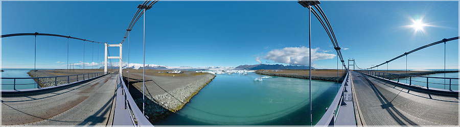
The flow of large ice from the lake to the sea takes place depending on the tides. Indeed, at high tide, all the ice cubes are stuck in the lake, and the difference between freshwater (glacial melt) we perceive very well and seawater This creates a kind of "barage" and ice can not get out! By cons, once the tide begins to fall, there comes a time when the lake water is a little fuller, the forces are reversed, and all ice near the mouth escape! This phenomenon is visible with the pano-morphing below: assembly of several panoramas, taken at the same location at different times....
Read the full story. Panorama made of 13 x 3 photos taken on the 01 August 2013.
Click on the image to view the 360º panorama ! 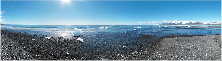
For the second time in Jokulsarlon, the ice has disappeared! Indeed, depending on tides and weather, there aplus or less ice on the beach....
Read the full story. Panorama made of 13 x 3 photos taken on the 01 August 2013.
Click on the image to view the 360º panorama ! 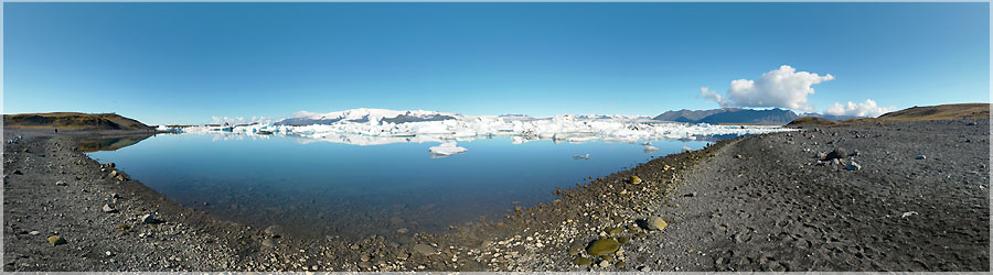
Panorama made of 13 x 3 photos taken on the 01 August 2013.
Click on the image to view the 360º panorama ! 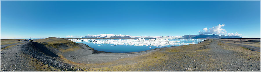
Panorama made of 13 x 3 photos taken on the 01 August 2013.
Click on the image to view the 360º panorama ! 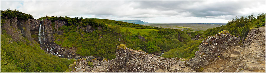
Panorama made of 13 x 3 photos taken on the 31 July 2013.
Click on the image to view the 360º panorama ! 
Here is a rare bridge when Landmannalaugar trek. In fact, throughout the trek, I seem to remember that there are four: one for cars, pedestrians and 3 only!...
Read the full story. Panorama made of 13 x 3 photos taken on the 29 July 2013.
Click on the image to view the 360º panorama ! 
We appercevons this image off the Alfatvan lake. A big black cloud does not inspire confidence especially, is the volcano wakes up? Indeed, the famous Eyjafjallajokull volcano is right in the direction of cloud ......
Read the full story. Panorama made of 13 x 3 photos taken on the 27 July 2013.
Click on the image to view the 360º panorama ! 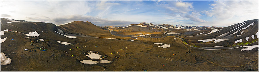
There is enough wind to Matthieu makes a panoramic air. The wind is not very consistent, it swirls, rushes into the valley, twirls above the peaks, it should not be the camera eventually land at the beginning of time!...
Read the full story. Panorama made of 7 photos taken on the 26 July 2013.
Click on the image to view the 360º panorama ! 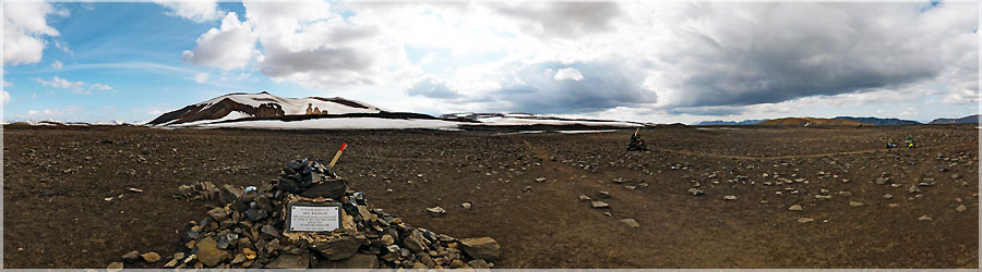
In fact, I'm wrong, the weather will remain mild but a few more days on the ridge, the wind is unbearable, we hurry to arrive at the shelter where we sleep. Just before arriving at the shelter, we pause before the memorial cairn to the memory of Ido Keinan....
Read the full story. Panorama made of 13 x 3 photos taken on the 26 July 2013.
Click on the image to view the 360º panorama ! 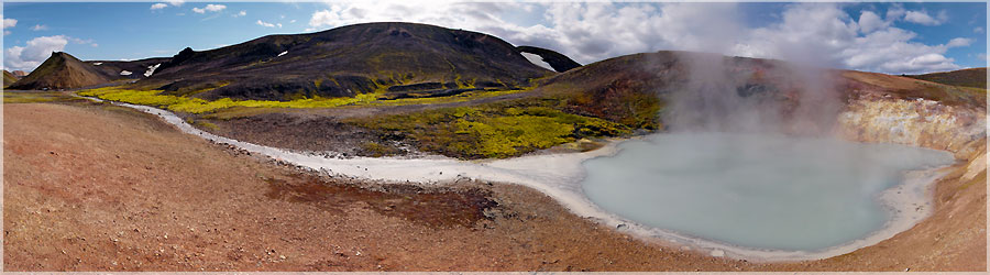
Along the way, we take the time to make a detour to admire beautiful colored hot springs water: geothermal area Storihver....
Read the full story. Panorama made of 13 x 3 photos taken on the 26 July 2013.
Click on the image to view the 360º panorama ! 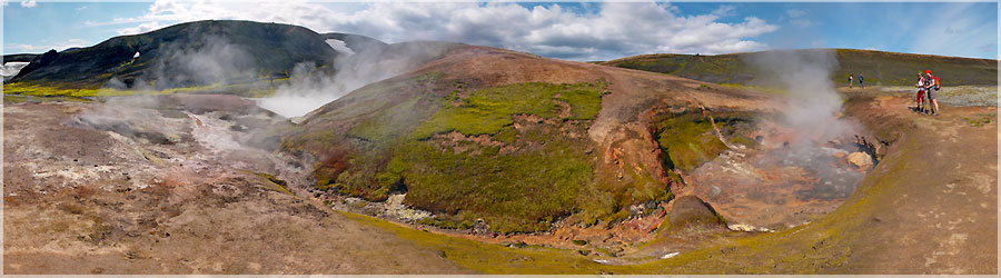
We spend our last night in Landmannalaugar and set off on the trek that connects Landmannalaugar Skogar. We loaded like mules, we carry tents, sleeping bags, mattresses, camera, stove, fuel, clothing and lyophilized for 6 days ... Tonight we sleep in the shelter of Hrafntinnusker. Unfortunately, the course is very windy and I fear the return of a classic weather!...
Read the full story. Panorama made of 13 x 3 photos taken on the 26 July 2013.
Click on the image to view the 360º panorama ! 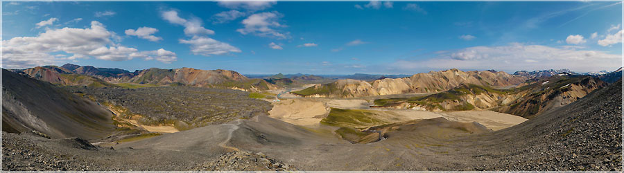
Magnificent view over the valley of Landmannalaugar in the rise of Bláhnúkur....
Read the full story. Panorama made of 13 x 3 photos taken on the 25 July 2013.
Click on the image to view the 360º panorama ! 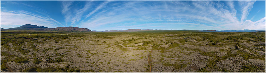
Just before leaving, the wind picked up strongly, and I want to try an aerial view! This is the second aerial view, I had achieved in France just before leaving for test equipment ... At least I have not worn any for nothing pendans 3 weeks!...
Read the full story. Panorama made of 8 photos taken on the 28 July 2012.
Click on the image to view the 360º panorama ! 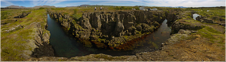
This place is incredibly relaxing! So I do not know if the well-being I feel is due to the energy that emanates from this place or the sun reappears but I feel good! And I understand that the first Icelandic parliament has decided to settle there! Indeed, this place also has a historical dimension. It is the symbol of an independent Iceland....
Read the full story. Panorama made of 12 x 3 photos taken on the 28 July 2012.
Click on the image to view the 360º panorama ! 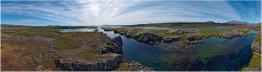
The water clarity and beautiful turquoise blue colors make you want to bathe though I support the pole without problem!...
Read the full story. Panorama made of 12 photos taken on the 28 July 2012.
Click on the image to view the 360º panorama ! 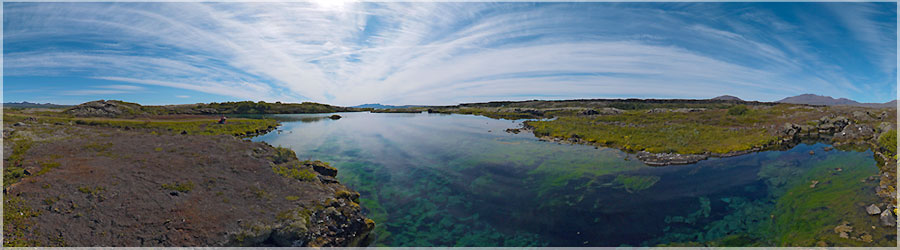
In some places, the fault is filled with water, it is a magical spectacle under the sun. Some devote themselves to diving and it would give us almost feel like we put for the show must be beautiful....
Read the full story. Panorama made of 12 photos taken on the 28 July 2012.
Click on the image to view the 360º panorama ! 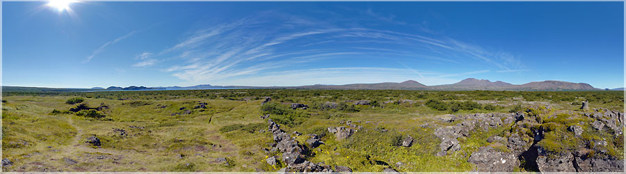
We make a short hike to get away from the world, from the crowd, to the top of Skogarkot : old camp....
Read the full story. Panorama made of 12 x 3 photos taken on the 28 July 2012.
Click on the image to view the 360º panorama ! 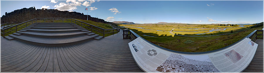
Panorama made of 12 x 3 photos taken on the 27 July 2012.
Click on the image to view the 360º panorama ! 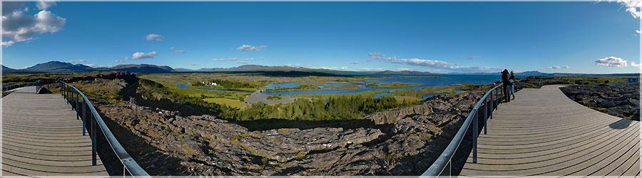
Panorama made of 12 x 3 photos taken on the 27 July 2012.
Click on the image to view the 360º panorama ! 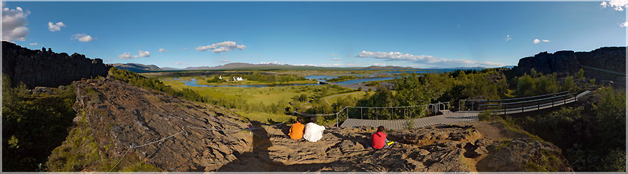
Panorama made of 12 x 3 photos taken on the 27 July 2012.
Click on the image to view the 360º panorama ! 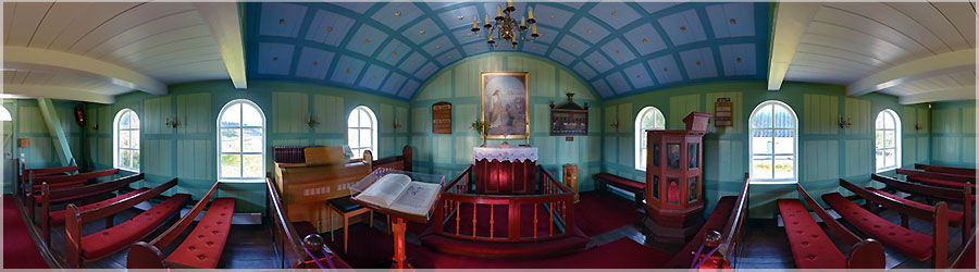
Panorama made of 12 x 3 photos taken on the 27 July 2012.
Click on the image to view the 360º panorama ! 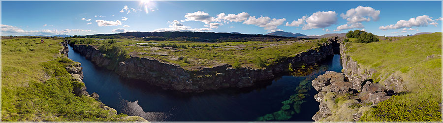
We learn that the bus is a plain where the rift between the North American tectonic plate and the Eurasian plate. Every day these two plates diverge a little more creating frequent shocks (48h on, we do not feel any!)....
Read the full story. Panorama made of 12 x 3 photos taken on the 27 July 2012.
Click on the image to view the 360º panorama ! 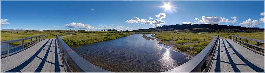
For the last 2 days of our stay, we want to discover Thingvellir. We know not initially great thing about this place except that it is part of the UNESCO World Heritage and is part of the golden triangle Geysir and Gullfoss with. Gradually as we move forward and progress in this peaceful place, we learn a lot about the culture and the foundation of Iceland....
Read the full story. Panorama made of 12 x 3 photos taken on the 27 July 2012.
Click on the image to view the 360º panorama ! 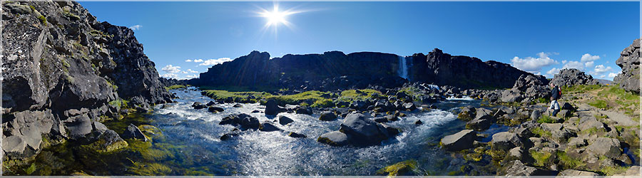
Waterfall Öxarárfoss, meaning in French "cascade Öxará", is located in the national park Thingvellir, over the course of the river Öxará. It crosses over a difference of a few meters the first part of the escarpment formed by the Almannagjá fault....
Read the full story. Panorama made of 12 x 3 photos taken on the 27 July 2012.
Click on the image to view the 360º panorama ! 
Panorama made of 12 x 3 photos taken on the 26 July 2012.
Click on the image to view the 360º panorama ! 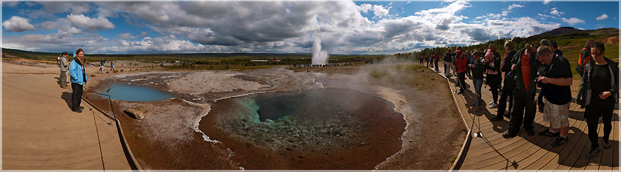
Around the Geysir geyser is the source of hot water Fata: Gorgeous! This cavity has formde a seal, hence its name (Fata)....
Read the full story. Panorama made of 12 x 3 photos taken on the 26 July 2012.
Click on the image to view the 360º panorama ! 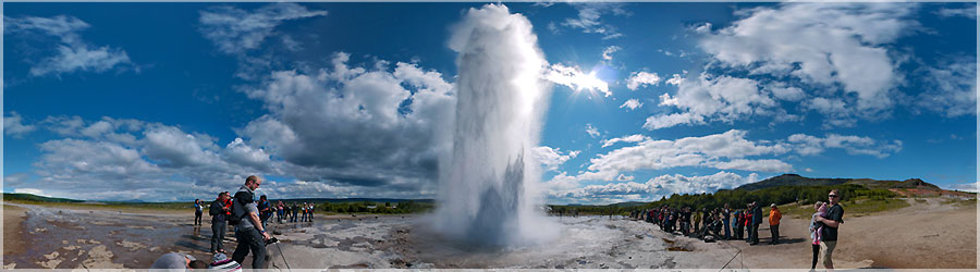
At Geysir we plant our tent and enjoy the spectacle of this bubbling water "explodes" in a very high jet for the delight of the audience! This panoramic video was even encrusted! This can really feel on-site immersion guaranteed!...
Read the full story. Panorama made of 12 x 3 photos taken on the 26 July 2012.
Click on the image to view the 360º panorama ! 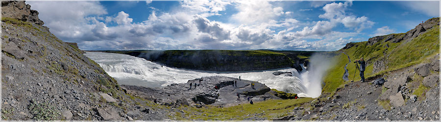
We find the drop Gullfoss as the first day. This is one of the busiest places in Iceland. Geysir and Thingvellir with , they are called the Golden Triangle . Many visitors who have little time to visit the golden triangle in the day from Reykjavik. These places are quite equipped compared to the rest of Iceland. It contains an explanatory path, a shop and a restaurant (where we will warm soup !) . Nevertheless, this fall is really beautiful, it is the width that impresses me the most. As we move into the bus, we are dependent on bus schedules ... and remain a good time there! We are quite happy with what means of transport : no problem puncture or ford to pass as with a rental car ! But it takes a bit of organization ( in some places, the bus passes only once a day or once every two days in some more remote places ! Consult small guide with schedules ... ) and must agree to be dependent and lose a little time ....
Read the full story. Panorama made of 12 x 3 photos taken on the 26 July 2012.
Click on the image to view the 360º panorama ! 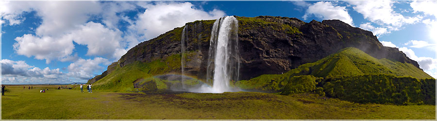
After a detailed study of the weather forecast on the internet, we decided not to stay in Skaftafell but heading to the West (Gullfoss, Geysir and Thingvellir) where we hope the sun waiting for us. The journey is long, today we take the bus to Selfoss and redo the route in reverse: Skaftafell Vik, the black sand beach of Reynisfjall, then Skogarfoss Selfoss where we seek the campsite ... Once the campsite found we plant our tent and wash our clothes. There is nothing special to do in Selfoss but tomorrow we'll just have time to redo our bags and take the bus to Gullfoss! The bus paused at Seljalandsfoss, where you can enjoy a beautiful rainbow in the sky!...
Read the full story. Panorama made of 12 x 3 photos taken on the 25 July 2012.
Click on the image to view the 360º panorama ! 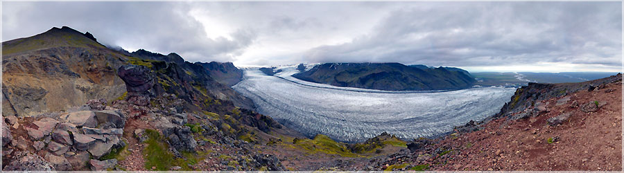
A steep and slippery path even ask me a bit of trouble so that Matthieu's picking me :-)! The view up there is superb: you can appreciate both sides of the top two glaciers....
Read the full story. Panorama made of 12 x 3 photos taken on the 24 July 2012.
Click on the image to view the 360º panorama ! 
This is a great day hiking tiring but well worth it! The rise seems long but it must be said that Iceland we were not accustomed to much altitude!...
Read the full story. Panorama made of 12 x 3 photos taken on the 24 July 2012.
Click on the image to view the 360º panorama ! 
When we wake up, the rain stopped. I do not say it's nice but we can enjoy the day to a peak: the Kristinartindar (1126m)....
Read the full story. Panorama made of 12 x 3 photos taken on the 24 July 2012.
Click on the image to view the 360º panorama ! 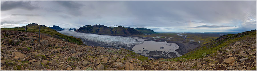
Panorama made of 12 x 3 photos taken on the 23 July 2012.
Click on the image to view the 360º panorama ! 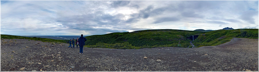
Panorama made of 12 x 3 photos taken on the 23 July 2012.
Click on the image to view the 360º panorama ! 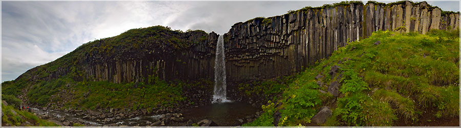
Panorama made of 12 x 3 photos taken on the 23 July 2012.
Click on the image to view the 360º panorama ! 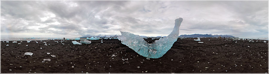
Panorama made of 12 x 3 photos taken on the 23 July 2012.
Click on the image to view the 360º panorama ! 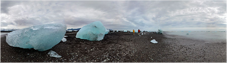
The huge blue ice will then fail on a black sand beach, passing under the bridge, which is a feast for our eyes!...
Read the full story. Panorama made of 12 x 3 photos taken on the 23 July 2012.
Click on the image to view the 360º panorama ! 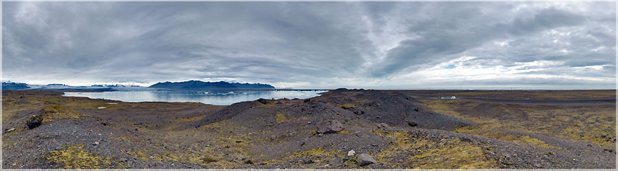
Panorama made of 12 x 3 photos taken on the 23 July 2012.
Click on the image to view the 360º panorama ! 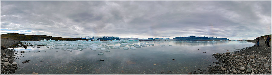
Panorama made of 12 x 3 photos taken on the 23 July 2012.
Click on the image to view the 360º panorama ! 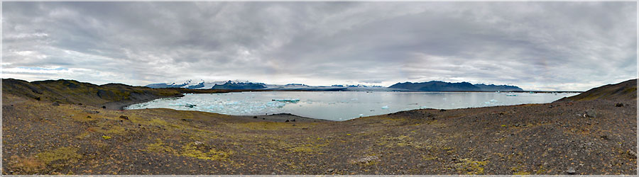
Panorama made of 12 x 3 photos taken on the 23 July 2012.
Click on the image to view the 360º panorama ! 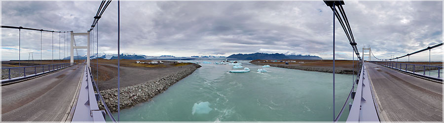
It is a glacial lake of incredible beauty as pieces of ice break off the glacier and fall into the lake....
Read the full story. Panorama made of 12 x 3 photos taken on the 23 July 2012.
Click on the image to view the 360º panorama ! 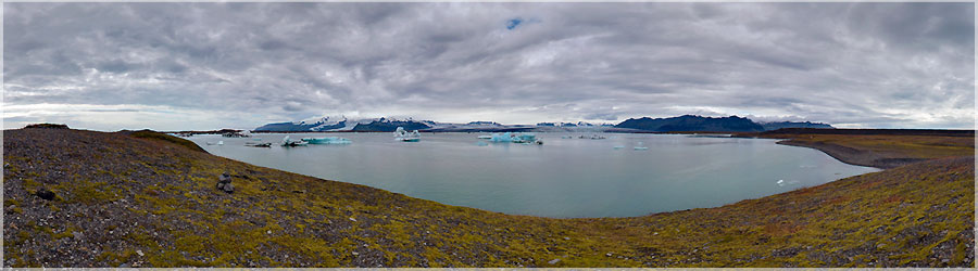
The weather forecast told us that this would be the best day of the next 3 days. So we go to Jokulsarlon, a mythical places in Iceland that we regretted not having seen during our first stay. Indeed, this place is famous because it is here that two James Bond movies were filmed: "Kill" and "Tomorrow Never Dies"....
Read the full story. Panorama made of 12 x 3 photos taken on the 23 July 2012.
Click on the image to view the 360º panorama ! 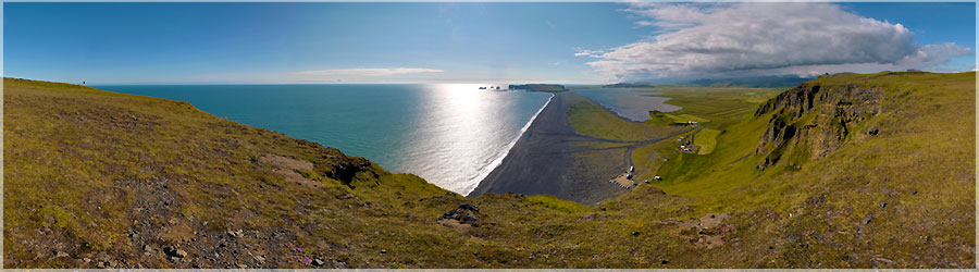
Iceland is made of different weather, it can make a beautiful sun on a beach in the south and at the same time less than 50 km as the crow flies, have a terrible storm on top of a glacier ! We become aware of this fact and the consequences this may have on the rest of our stay. And if we decide our itinerary for the coming days depending on the weather? A Vik, we seek the campsite, plant our tent and leave for the hike (it is only 15h) hoping to see the famous puffins ... Matthieu sees one but it has already flown when I return .. . To say what is, we are a little disappointed with the ride ......
Read the full story. Panorama made of 12 x 3 photos taken on the 20 July 2012.
Click on the image to view the 360º panorama ! 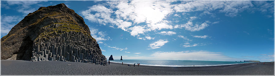
The second and final stop of the bus will be on a black sand beach in Reynisfjall. That this morning we were still in the mountains and we had lunch by the sea! This beach is beautiful and we are amazed at the basalt columns carved by the sea A ray of sunshine comes the light while we are there....
Read the full story. Panorama made of 12 x 3 photos taken on the 20 July 2012.
Click on the image to view the 360º panorama ! 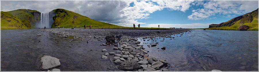
Panorama made of 12 x 3 photos taken on the 20 July 2012.
Click on the image to view the 360º panorama ! 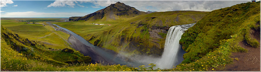
It's funny as every fall is different from the other, after all, these are just waterfalls ... but each has its own characteristics!...
Read the full story. Panorama made of 12 x 3 photos taken on the 20 July 2012.
Click on the image to view the 360º panorama ! 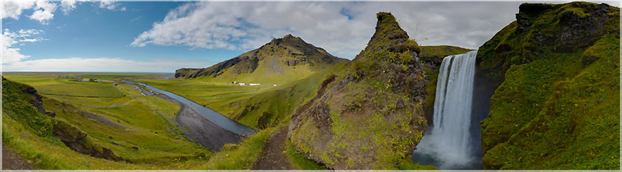
The second bus paused at Skogarfoss which is where the final stage of the trek (that we have not been able to) stop! This drop is 62 m in height but is much wider than the previous one....
Read the full story. Panorama made of 12 x 3 photos taken on the 20 July 2012.
Click on the image to view the 360º panorama ! 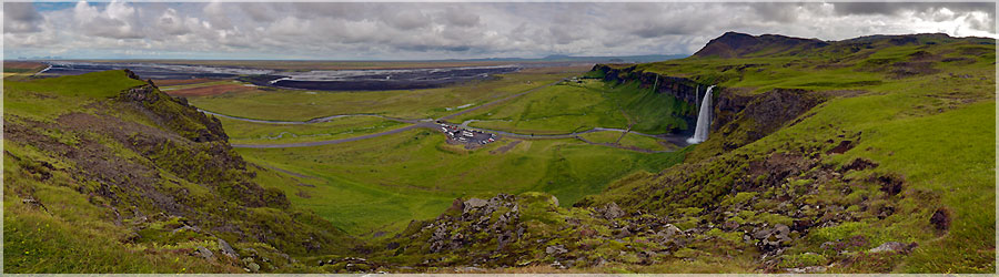
Matthieu even the luxury small mountain to climb around the waterfall for a panoramic view from above, and see the waterfall in its entirety....
Read the full story. Panorama made of 12 x 3 photos taken on the 20 July 2012.
Click on the image to view the 360º panorama ! 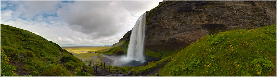
Then we enjoy the peace and beauty of the place where the buses fill up and go to new places! The waterfall is amazing, you can go behind the waterfall which makes it even more impressive! It measures 65 m in height....
Read the full story. Panorama made of 12 x 3 photos taken on the 20 July 2012.
Click on the image to view the 360º panorama ! 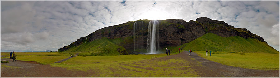
We take the bus to Vik where we spotted a ride on a cliff that would see puffins! To our amazement Thorsmork night was quiet, and we can fold the tent almost dry ... By cons, we feel that the rain is not far away and the weather is unstable. It is without regret that we leave Thorsmork! The bus we take to stop us Seljalandsfoss waterfall where we change buses! Correspondence is long enough for us to see "land" the whole bus tourists should participate in Tour ......
Read the full story. Panorama made of 12 x 3 photos taken on the 20 July 2012.
Click on the image to view the 360º panorama ! 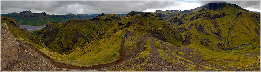
On the way back we see a guard who warns that the Icelandic weather forecast is for a storm tomorrow ... It is clear that we will not go further, we will take the bus back on the south coast. We still have so many things to see that it would be a shame to wait here as the weather improves! We returned despite everything, smile because it had 3 babies foxes guard of incredible beauty!...
Read the full story. Panorama made of 12 x 3 photos taken on the 19 July 2012.
Click on the image to view the 360º panorama ! 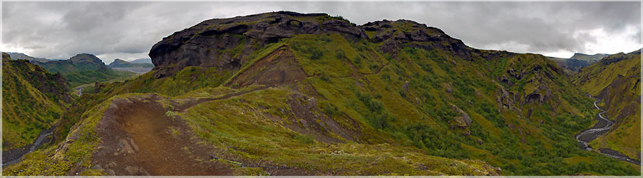
We lunch dry in the hut camping and waiting for the rain to stop to identify the path that we emprunterions if we continue the trek ... It brings back memories because in 2009, the river valley was saturated, swollen by the rains of the storm. We had to ask a group of Italian let us cross 4x4 walk because it was impossible, the current was too strong! This year we do not have this problem, we cross without pitfalls ... We walk along the trail and climb up a nice enough view that Matthieu makes two pans and we go camping....
Read the full story. Panorama made of 12 x 3 photos taken on the 19 July 2012.
Click on the image to view the 360º panorama ! 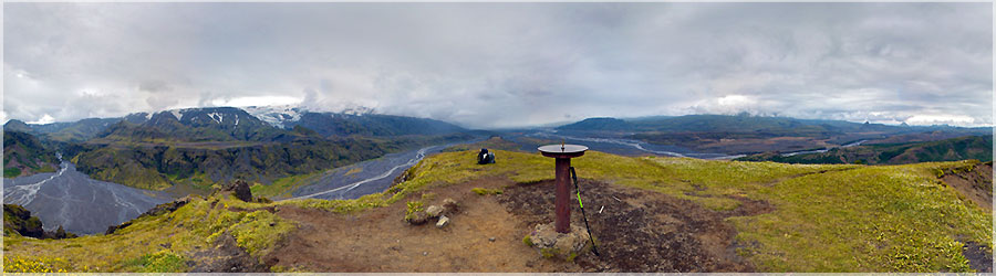
This morning it rains ... but a little thinning allows us to walk an hour to the top of Valahnukur. We spot the famous Eyjafjallajökull in the clouds. It is a beautiful ride! But it started raining again as we have just started to descend ......
Read the full story. Panorama made of 12 x 3 photos taken on the 19 July 2012.
Click on the image to view the 360º panorama ! 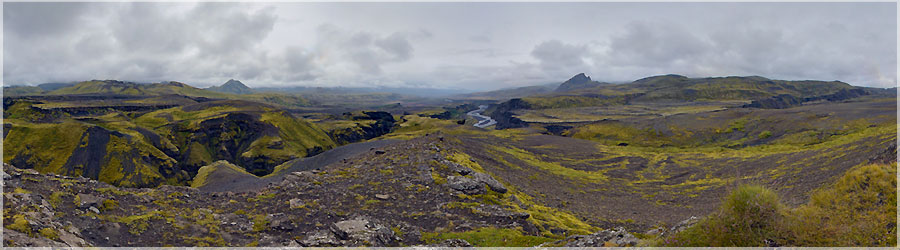
Indeed, it remains part of the trek that connects Thorsmork Skogar. On either side of this path there are two glaciers. At no time, we walk on the glaciers but we can observe our right and to our left. The Eyjafjallajökull glacier east to west, it is a small glacier but it is the home of the famous volcano that erupted in spring 2010 and has messed up the world's air traffic for a week. Following the eruption, we've told us that the landscape had changed and we were curious to see the new face of this part of the trek!...
Read the full story. Panorama made of 12 x 3 photos taken on the 18 July 2012.
Click on the image to view the 360º panorama ! 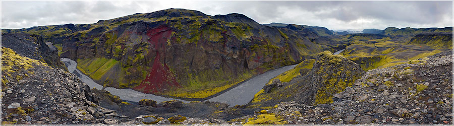
He then begins to rain and it is much more difficult for us to enjoy the beautiful scenery. Our sole aim is to arrive at the earliest next camping! When we do, we are happy to find a hut that can serve as a "common room" for all users of the campsite. As we first arrived, we stallions our rain capes and rain pants to dry and progressively other campers arrive, we store our equipment. We learn from the guard, the weather will not be better tomorrow, and even worse later ... We decided to stay one more day to enjoy the beauty of the place hoping that the weather improves ......
Read the full story. Panorama made of 12 x 3 photos taken on the 18 July 2012.
Click on the image to view the 360º panorama ! 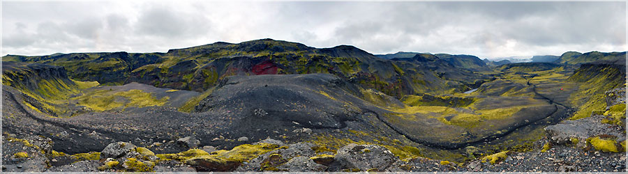
This day walk connects to Botnar Thorsmork. Thorsmork is a busy valley where a bus runs every day. We could stop our trek if the weather deteriorated. The step Botnar to Thorsmork is technically more difficult because it has a passage with chains. Beware if you are behind a group because you have to wait and take your troubles patiently! Passage with strings is one to one ... but is quite doable if you do not have vertigo! We then cross a bridge rare trek and we quickly understand the purpose: it passes through a deep gorge impassable (at this point) without using the bridge....
Read the full story. Panorama made of 12 x 3 photos taken on the 18 July 2012.
Click on the image to view the 360º panorama ! 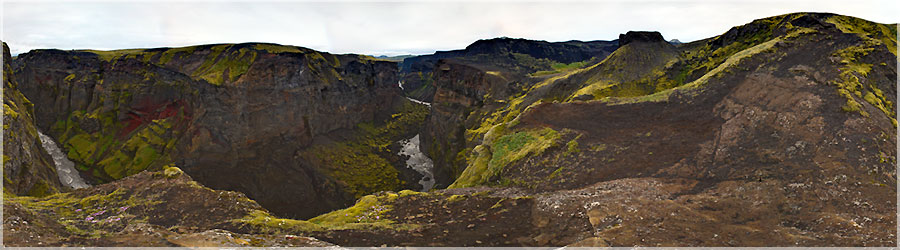
Flo : Height of walker is arriving at the campsite once the tent is pitched and the only mission that comes to me is to rest I lose my balance and fell on his knees leaving the toilet camping! What war wound! Two pizzas on each knee! Nothing serious, I walk as if nothing had happened and I feel nothing. I'm just afraid of being laughed at in August in France with my summer skirts! This does not prevent us from enjoying this beautiful evening for a digestive walk and walk to the gorge Svartikrokur. It is really worth it!...
Read the full story. Panorama made of 12 x 3 photos taken on the 17 July 2012.
Click on the image to view the 360º panorama ! 
I already have me in 2009! If we go back, I promise to be long enough for this army step!...
Read the full story. Panorama made of 12 x 3 photos taken on the 17 July 2012.
Click on the image to view the 360º panorama ! 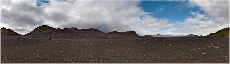
In the distance we see the mountains whose profile is gradually changing but if fatigue sets in and gradually the desire to achieve is becoming increasingly urgent!...
Read the full story. Panorama made of 12 x 3 photos taken on the 17 July 2012.
Click on the image to view the 360º panorama ! 
We continue our journey towards the refuge of Botnar. I find this rather long day because all along, we walk in a desert of black sand that never ends!...
Read the full story. Panorama made of 12 x 3 photos taken on the 17 July 2012.
Click on the image to view the 360º panorama ! 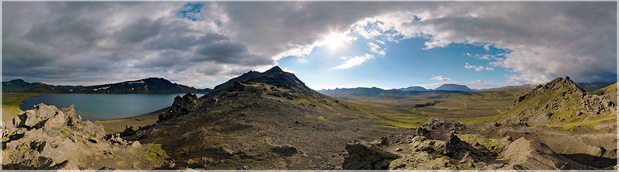
I forgot to tell you about the Landmannalaugar trek in general ... This is THE trek to Iceland, we note also that it is much busier in 2012 than in 2009 ... But we find attendance correct trek and at no time are bothered by "tourists" too many. He is known to be the most beautiful trek in Iceland and among one of the most beautiful in the world ... Our experience of all treks in the world is limited ... I do not say that the title one of the most beautiful treks in the world is justified, but I found this wonderful trek ... What we liked is the diversity of landscapes. Indeed, every day brings a new vision of Iceland, every day offers completely different from what preceded colors and reliefs! (day1: lava field - day 2: fumaroles - Day 3: lake, mountain and desert - Day 4: Gorge Vale - Day 5 Optional: glacier)...
Read the full story. Panorama made of 12 x 3 photos taken on the 16 July 2012.
Click on the image to view the 360º panorama ! 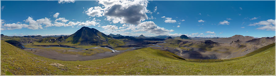
We walk quietly (without bag!), Enjoy the weather and stroll. This rest day is an opportunity for us to recharge the batteries for the rest of our adventures!...
Read the full story. Panorama made of 12 x 3 photos taken on the 16 July 2012.
Click on the image to view the 360º panorama ! 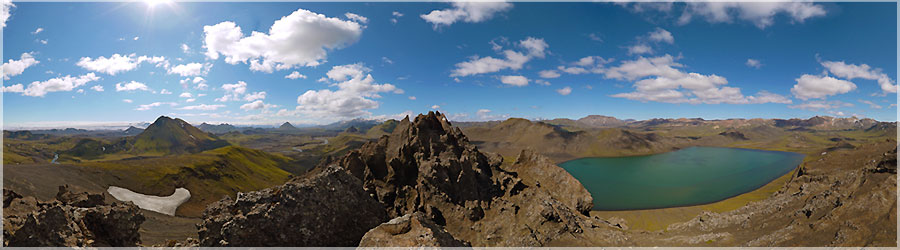
The contrast between the lake water (reminiscent of the sea) and sharp peaks is striking and beautiful....
Read the full story. Panorama made of 12 x 3 photos taken on the 16 July 2012.
Click on the image to view the 360º panorama ! 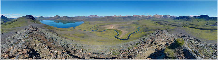
After a good night's sleep, we woke up with a big blue sky. We will be entitled to a perfect day with no wind and we have lunch in a T-shirt! Today's ride is a half around the lake on the ridges. Indeed, after 2 consecutive days of walking, we take a day break to relax and enjoy the lake Alftavan....
Read the full story. Panorama made of 12 x 3 photos taken on the 16 July 2012.
Click on the image to view the 360º panorama ! 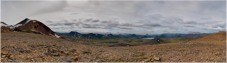
CThe second part of the path is composed of a long descent after which the lake and the campground is located . This is quite confusing because you see the lake from the beginning and that it seems not many come close ! Especially when it comes to face any flat last line and you have to cross a ford (the first trek) in the middle of it ! Skip fords , it's tiring , cold and it takes time! You have to sit , lay the bag , look for sandals. Remove shoes , store them in the bag , put the sandals. Replace the bag , take your courage in both hands, cross the ford ! Place the bag, take the shoes and towel , remove the sandals, dry feet, put socks and shoes and put away the towel and sandals . In general, at this stage , I am a cereal bar or some nuts and start again ! Walking , feet warm quickly and instantly forget the cold water of the river! The landscapes are preserved to the point that bridge reminds us of the intervention of mankind on nature....
Read the full story. Panorama made of 12 x 3 photos taken on the 15 July 2012.
Click on the image to view the 360º panorama ! 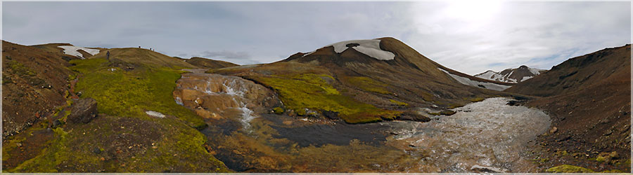
We leave for Lake Alftavan. Today is the birthday of Matthieu and I find difficult start. At first, the path is tiring because composed of small descents and short climbs as if every 10 m, a low of 2 m was excavated by a water court! Fumaroles walk the path and I imagine to be a elf browsing a path whose imperfections have been accentuated by my small ......
Read the full story. Panorama made of 12 x 3 photos taken on the 15 July 2012.
Click on the image to view the 360º panorama ! 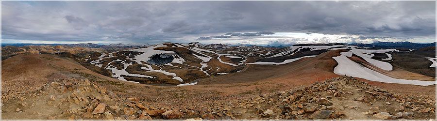
We have dinner at the refuge (yum good freeze!) And go for a digestive stroll atop Sodull. This is a ride much easier and much more crowded than the ice cave collapsed but once there, the view is magnificent!...
Read the full story. Panorama made of 12 x 3 photos taken on the 14 July 2012.
Click on the image to view the 360º panorama ! 
We arrived relatively early refuge and decide to leave for a trip to the ice cave collapsed in Sodull. The road is snowy, fortunately Matthieu is a good climber and I trust him because I do not advise inexperienced and poorly equipped people! What amazes me the most during this trip is the beauty and vastness of the landscape beyond "beaten path". It's amazing to get to see even more beautiful scenery trek out on the trek!...
Read the full story. Panorama made of 12 x 3 photos taken on the 14 July 2012.
Click on the image to view the 360º panorama ! 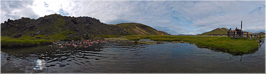
Back at the campsite, the only desire Flo is going to bathe in the hot spring! It motivates me because it is not easy to walk 200m in suit under this temperature and I rush! It is happiness! The closer you get to the source, the more water is hot. So much so that most people stop at the same place as if later, the water was too hot for it to be enjoyable! She is full of warmth, this place is conducive to relaxation and well-being. This is cool!...
Read the full story. Panorama made of 12 photos taken on the 13 July 2012.
Click on the image to view the 360º panorama ! 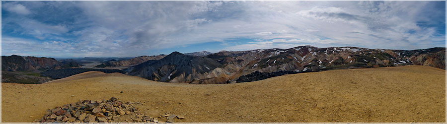
This is on top of Brennisteinsalda we go! Today too, it is a great time, we had lunch in a T-shirt! We take each of these precious minutes of good weather, and admire these so different from our everyday landscapes....
Read the full story. Panorama made of 12 x 3 photos taken on the 13 July 2012.
Click on the image to view the 360º panorama ! 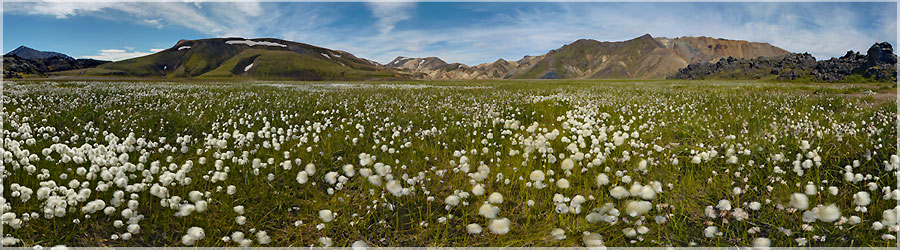
We decide to leave for a hike to the day: the tent and all the camping equipment will remain at Landmannalaugar!...
Read the full story. Panorama made of 12 x 3 photos taken on the 13 July 2012.
Click on the image to view the 360º panorama ! 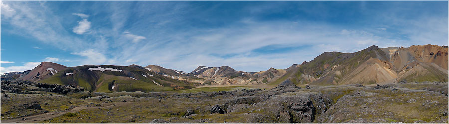
Panorama made of 12 x 3 photos taken on the 13 July 2012.
Click on the image to view the 360º panorama ! 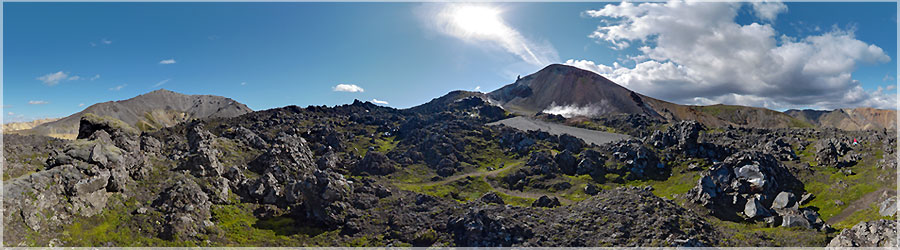
Of late, we find the path through the fumaroles and volcanic landscapes of the trek but this time, I want the blue sky to do some scenic....
Read the full story. Panorama made of 12 x 3 photos taken on the 12 July 2012.
Click on the image to view the 360º panorama ! 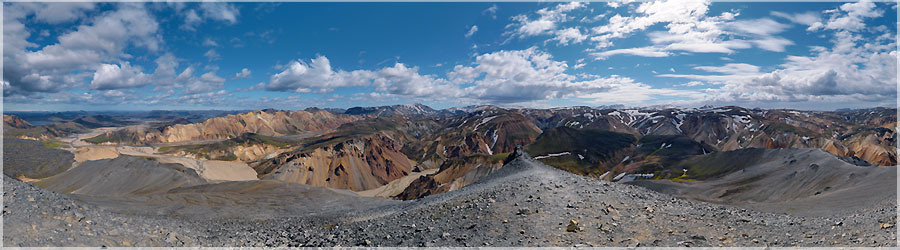
Panorama made of 12 x 3 photos taken on the 12 July 2012.
Click on the image to view the 360º panorama ! 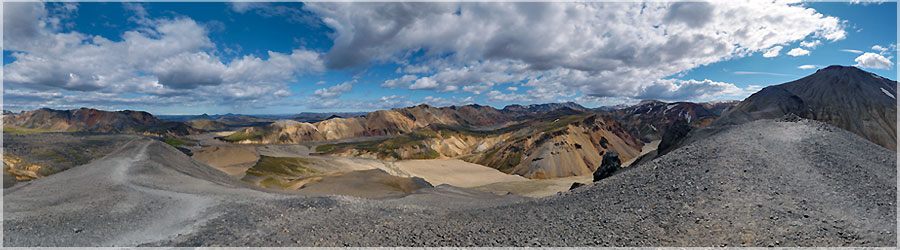
So we go to the top of Bláhnúkur that will allow us to have a panoramic view of the camper and the locality. It is a nice walk, we take our time, admire the scenery and galérons in a sandy descent ......
Read the full story. Panorama made of 12 x 3 photos taken on the 12 July 2012.
Click on the image to view the 360º panorama ! 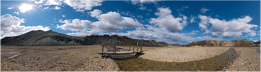
It is with great joy and excitement that we take the bus from Reykjavik to Landmannalaugar. I admire the landscape and I try not to miss a beat of the show that nature offers me. The closer we get, the more I recognize this undulating treeless landscape that looks like a desert of sand dunes which would have added all the colors of the rainbow sky ocher volcanic land of green moss that grows there. To our delight, these colors are enhanced by the blue sky. We arrived around 12pm, plant our tent, lunch and decided to go for a little hike with mild to half-day bag....
Read the full story. Panorama made of 12 x 3 photos taken on the 12 July 2012.
Click on the image to view the 360º panorama ! 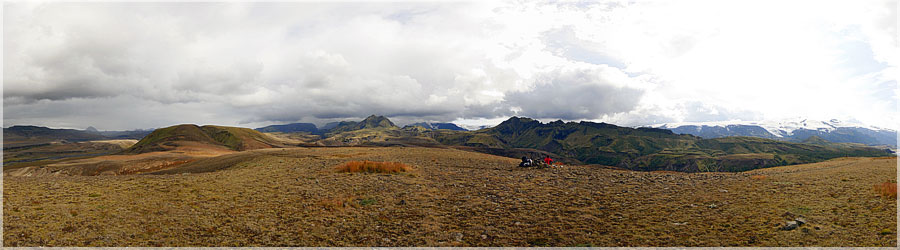
Just before arriving at Porsmork: before the last step leading us to Skogar, where we will walk with more than 12 backpacks in complete autonomy, accessible through a pass between two glaciers, snow, after more than 1000m in altitude, we value our last moments of rest. Rest of short duration, as seen on this picture on one side the blue sky and the sun warms us, and on the other side threatening clouds, spilling their water thoroughly... we soaked after 10 minutes left... ...
Read the full story. Panorama made of 11 photos taken on the 09 August 2009.
Click on the image to view the 360º panorama ! 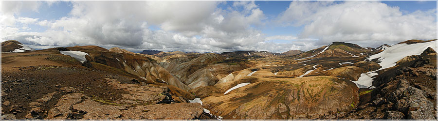
Beautiful colors on the plains during the trek Svartihryggur Landamannalaugar (original colors... )
Panorama made of 10 photos taken on the 09 August 2009.
Click on the image to view the 360º panorama ! 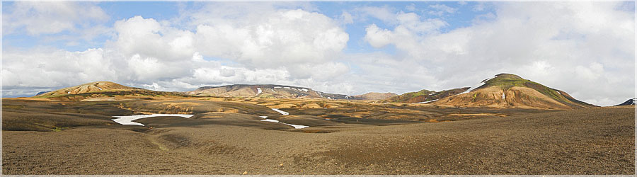
During the trek Landmannalaugar, we alternate crossings plains, deserts, rivers... ...
Read the full story. Panorama made of 9 photos taken on the 09 August 2009.
Click on the image to view the 360º panorama ! 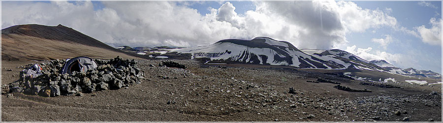
During this trek of 5 days in total autonomy, we plant our tent the first night near a refuge (camping allowed), we finally arrimmons with straps as we can on the ground both sandy and hard as of the Pier, and encircle a small wall of Piers to limit the onslaught of wind... Chilly refrain!...
Read the full story. Panorama made of 12 x 3 photos taken on the 09 August 2009.
Click on the image to view the 360º panorama ! 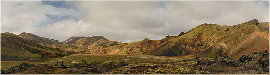
Beautiful scenery of Landmannalaugar, a small clearing we can admire all the green colors on the sides of mountains....
Read the full story. Panorama made of 12 x 3 photos taken on the 08 August 2009.
Click on the image to view the 360º panorama ! 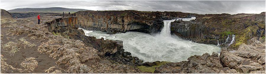
On the road to Landmannalaugar, the bus stops near the waterfall Aldeyjarfoss, impressed by the shape of the rocks around!...
Read the full story. Panorama made of 13 x 3 photos taken on the 05 August 2009.
Click on the image to view the 360º panorama ! 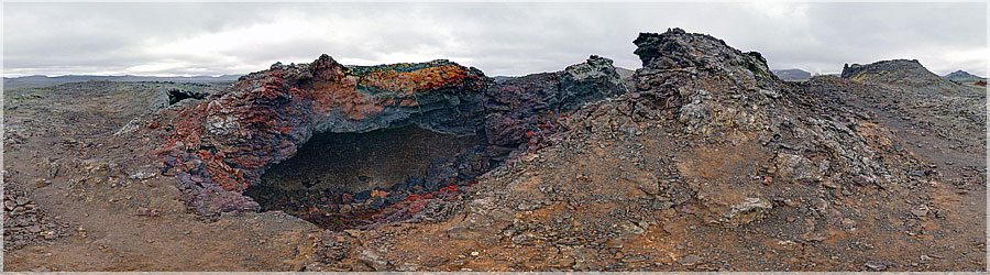
When returning to Lake Myvatn Krafla on foot for 2 hours we cross a lava field, and what a surprise to see all the shades of color in these lavas, the dark blue, purple, to red, the orange and even yellow! No photo retouching abusive!...
Read the full story. Panorama made of 13 x 3 photos taken on the 03 August 2009.
Click on the image to view the 360º panorama ! 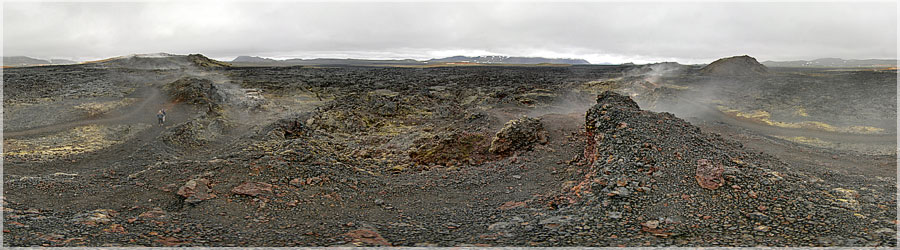
Krafla area is a little desert, where there was no tag to identify it would be easy to get lost on the lunar terrain. At times, you'd float elves, but they are as fumaroles... whatever... ...
Read the full story. Panorama made of 13 x 3 photos taken on the 03 August 2009.
Click on the image to view the 360º panorama ! 
Krafla area had no recent eruptions, though the steam escaping from fumaroles and smallest cracks and holes... ...
Read the full story. Panorama made of 13 x 3 photos taken on the 03 August 2009.
Click on the image to view the 360º panorama ! 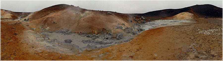
At Krafla, another pool of mud, this time boiling, it is good to warm up in the corner... by cons, sulphurous smells are not always pleasant!...
Read the full story. Panorama made of 16 photos taken on the 03 August 2009.
Click on the image to view the 360º panorama ! 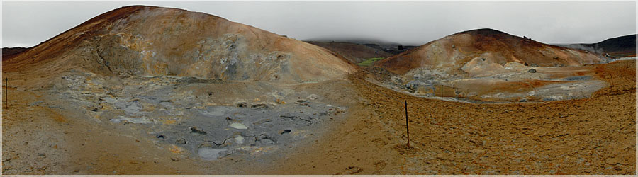
At Krafla, still active volcanic area, exploited for its deposits of hot water, a path is drawn in the mud, avoiding the hottest areas! Significant risk of burns!...
Read the full story. Panorama made of 16 photos taken on the 03 August 2009.
Click on the image to view the 360º panorama ! 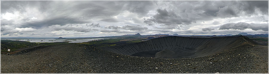
The climb is not difficult on this unstable ground composed of lava dust and small stones, but on arrival at the summit, a strong wind and cold, we were spared the flanks of the volcano during the rise, destabilizes the marchers, as to make us fall! Hold on!...
Read the full story. Panorama made of 15 x 3 photos taken on the 04 August 2009.
Click on the image to view the 360º panorama ! 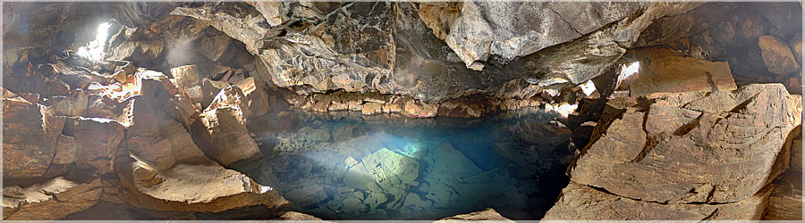
Under the previous flaw, a small opening to crawl under the rock, and enjoy the sun illuminating the hot water and vapor in the cavity....
Read the full story. Panorama made of 13 x 3 photos taken on the 04 August 2009.
Click on the image to view the 360º panorama ! 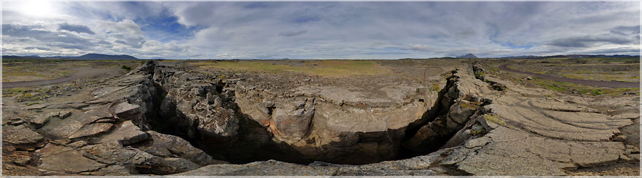
To turn a corner, we find that we must step over this flaw to move on. Be careful not to fall in!...
Read the full story. Panorama made of 9 x 3 photos taken on the 04 August 2009.
Click on the image to view the 360º panorama ! 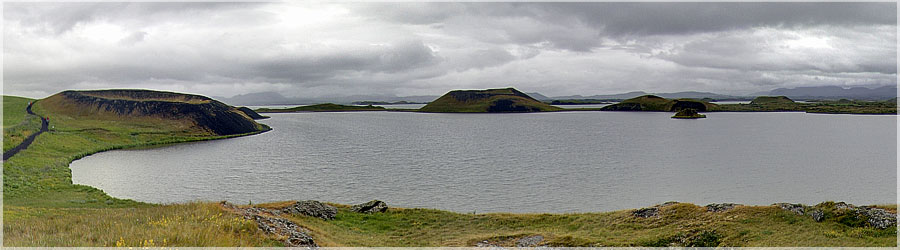
South of Lake Myvatn, Stakholstjorn of ancient volcanoes, whose peaks emmergent of the lake....
Read the full story. Panorama made of 13 x 3 photos taken on the 02 August 2009.
Click on the image to view the 360º panorama ! 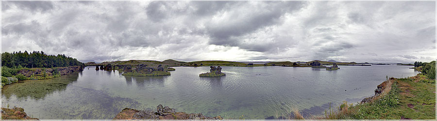
Panorama made of 12 x 3 photos taken on the 02 August 2009.
Click on the image to view the 360º panorama ! 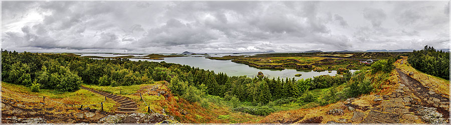
In bike ride around Lake Myvatn, break on the rock to enjoy the view quiet and peaceful....
Read the full story. Panorama made of 12 x 3 photos taken on the 02 August 2009.
Click on the image to view the 360º panorama ! 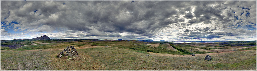
Back the top of Hlidarfjall, short break to contemplate the majestic Lake Myvatn, under a sky dotted with small cottony clouds... ...
Read the full story. Panorama made of 12 x 3 photos taken on the 01 August 2009.
Click on the image to view the 360º panorama ! 
At the top of Hlidarfjall, beautiful views of Lake Myvatn and surroundings. This summit is not very high (771m), but the rise is very tiring and unstable, because this mountain is composed of small lava rock, the whole is quite friable, and it slides easily. In winter, skiing can be practiced Hlidarfjall....
Read the full story. Panorama made of 13 x 3 photos taken on the 01 August 2009.
Click on the image to view the 360º panorama ! 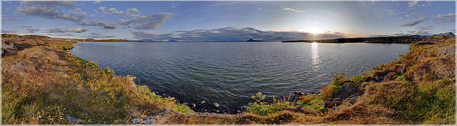
A very special sunset on the shores of Lake Myvatn. It is around 11:00 p.m. when this picture was taken... the country where the sun never sets in summer!
Panorama made of 13 x 3 photos taken on the 02 August 2009.
Click on the image to view the 360º panorama ! 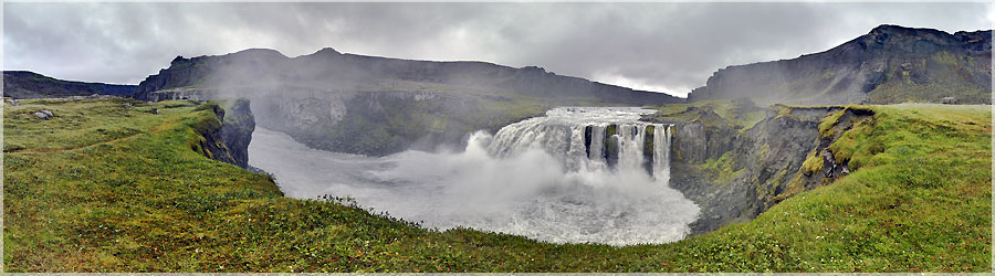
Waterfall Rettarfoss, beautiful, as many less traveled: to get there, you have to walk a few hours, then go down a corridor with a thick rope!...
Read the full story. Panorama made of 12 x 3 photos taken on the 30 July 2009.
Click on the image to view the 360º panorama ! 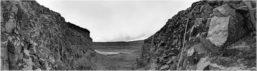
Shortly after the Waterfall Dettifoss, a rather delicate way, equipped with thick rope, used to go and continue the hike. The hardest are the bags... Heavy!...
Read the full story. Panorama made of 12 x 3 photos taken on the 30 July 2009.
Click on the image to view the 360º panorama ! 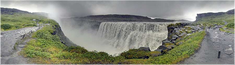
Dettifoss is a waterfall in the north of Iceland, in the canyon to Jokulsa Fjöllum, between falls and Selfoss Hafragilsfoss. They say it is the most powerful in Europe, with a rate of about 200 m3 / s, with a height of 44 meters....
Read the full story. Panorama made of 12 x 3 photos taken on the 30 July 2009.
Click on the image to view the 360º panorama ! 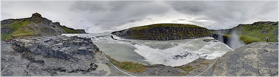
Gullfoss (the fall of gold) is a succession of two waterfalls with a height of 35 m and a width of 70 m, located on the river Hvita. Its name comes from the arc in the sky that can often be seen above....
Read the full story. Panorama made of 13 x 3 photos taken on the 28 July 2009.
Click on the image to view the 360º panorama !