
Aurora Borealis
Panorama made of 13 photos taken on the 10 October 2024.
Click on the image to view the 360º panorama ! 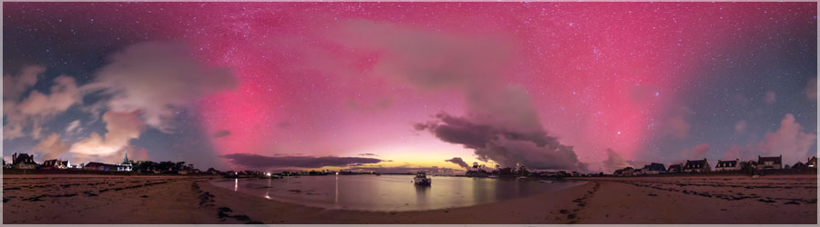
Aurora Borealis
Panorama made of 13 photos taken on the 10 October 2024.
Click on the image to view the 360º panorama ! 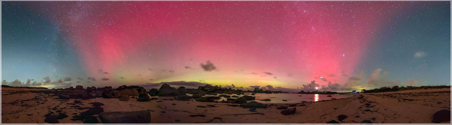
Aurora Borealis
Panorama made of 13 photos taken on the 10 October 2024.
Click on the image to view the 360º panorama ! 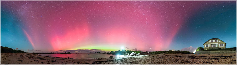
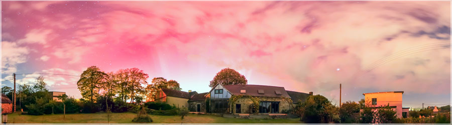
Aurora Borealis
Panorama made of 13 photos taken on the 10 October 2024.
Click on the image to view the 360º panorama ! 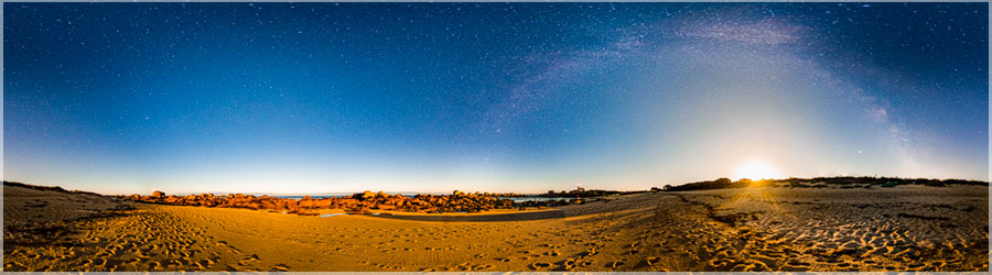
Moon
Panorama made of 13 photos taken on the 05 August 2020.
Click on the image to view the 360º panorama ! 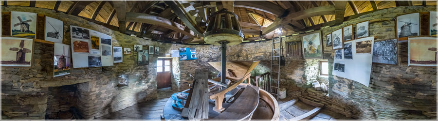
Mill Kercousquet
Panorama made of 12 photos taken on the 24 July 2020.
Click on the image to view the 360º panorama ! 
Comete Neowise 2020
Panorama made of 12 photos taken on the 23 July 2020.
Click on the image to view the 360º panorama ! 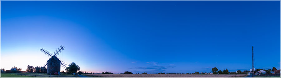
Comete Neowise 2020
Panorama made of 12 photos taken on the 23 July 2020.
Click on the image to view the 360º panorama ! 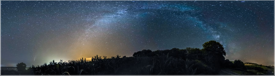
Comete Neowise 2020
Panorama made of 12 photos taken on the 18 July 2020.
Click on the image to view the 360º panorama ! 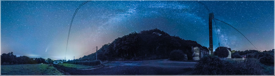
Comete Neowise 2020
Panorama made of 12 photos taken on the 18 July 2020.
Click on the image to view the 360º panorama ! 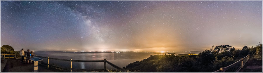
Comete Neowise 2020
Panorama made of 12 photos taken on the 18 July 2020.
Click on the image to view the 360º panorama ! 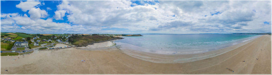
Beach Pentrez
Panorama made of 8 photos taken on the 17 July 2020.
Click on the image to view the 360º panorama ! 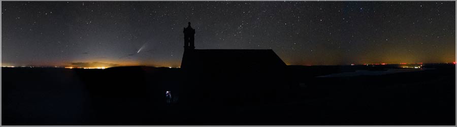
Comete Neowise 2020
Panorama made of 12 photos taken on the 12 July 2020.
Click on the image to view the 360º panorama ! 
Renovation Vieille longere
Panorama made of 13 photos taken on the 01 July 2020.
Click on the image to view the 360º panorama ! 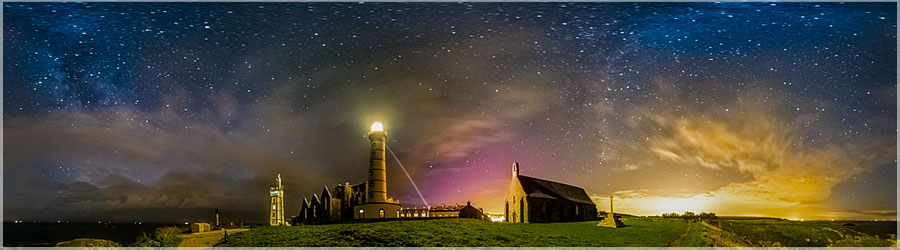
Wednesday night, the unusual solar activity has allowed us to observe until France a tiny northern lights, red shades / purple / pink. Do you see?
Panorama made of 13 photos taken on the 07 October 2015.
Click on the image to view the 360º panorama ! 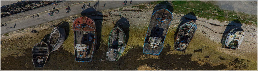
The port of Camaret
Panorama made of 12 photos taken on the 20 September 2015.
Click on the image to view the 360º panorama ! 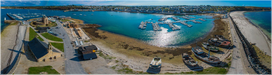
The port of Camaret
Panorama made of 12 photos taken on the 20 September 2015.
Click on the image to view the 360º panorama ! 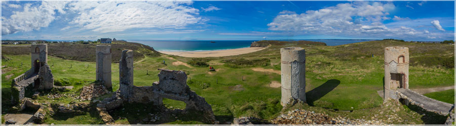
The mansion St Pol Roux the Magnificent, French poet.
Panorama made of 12 photos taken on the 20 September 2015.
Click on the image to view the 360º panorama ! 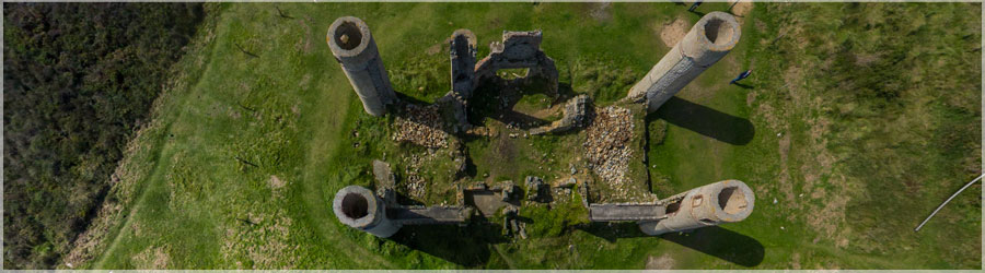
The mansion St Pol Roux the Magnificent, French poet.
Panorama made of 12 photos taken on the 20 September 2015.
Click on the image to view the 360º panorama ! 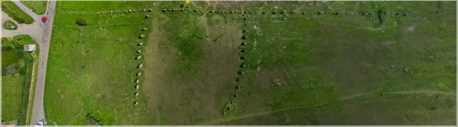
Alignment of menhirs Lagatjar: 65 menhirs spread over 200m long, oriented on 3 rows
Panorama made of 12 photos taken on the 20 September 2015.
Click on the image to view the 360º panorama ! 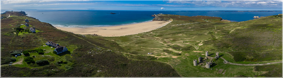
View performed kite on the Crozon peninsula: one discovers the mansion St Pol Roux the Magnificent, alignment of menhirs Lagatjar, we guess off the village of Camaret and the Pen-hir
Panorama made of 12 photos taken on the 20 September 2015.
Click on the image to view the 360º panorama ! 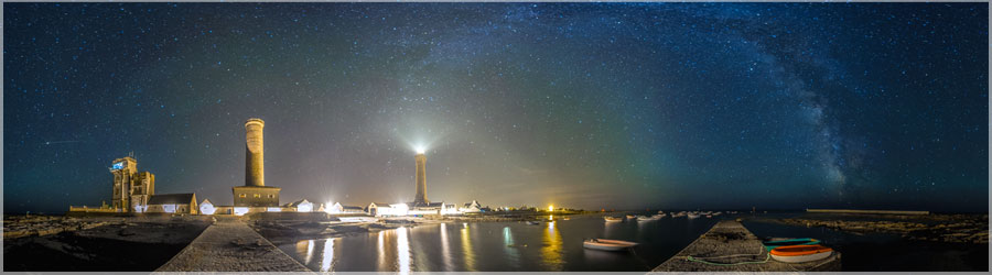
Photos of the Milky Way in Penmarch
Panorama made of 12 photos taken on the 10 August 2015.
Click on the image to view the 360º panorama ! 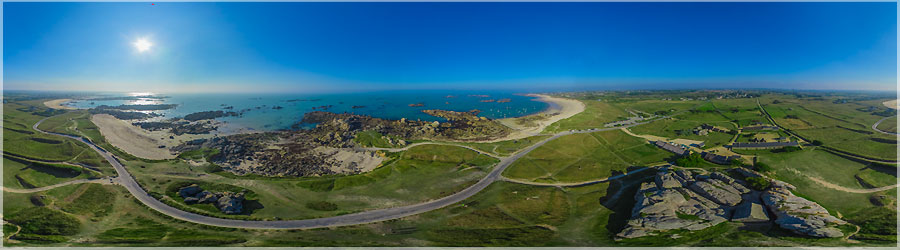
Meneham is a hamlet in the municipality of Kerlouan in northern Brittany. This house was built to guard the coast, this is the only building facing the sea Originally militiamen were installed and customs from 1792 Also look oven to wrack of trepézoïdale form. . It is about 10m long, with 70cm wide.
Panorama made of 12 photos taken on the 03 September 2014.
Click on the image to view the 360º panorama ! 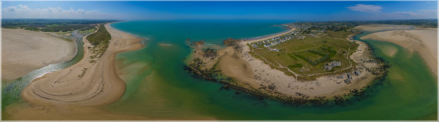
Beach Porz Meur in northern Brittany. The weather was foggy, we do not see the difference between the sea and the sky on the horizon! Notice the color gradient in the sea ...
Panorama made of 10 photos taken on the 03 September 2014.
Click on the image to view the 360º panorama ! 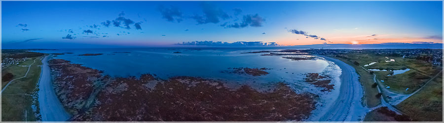
Kérity located, close to the magnificent lighthouse Eckmühl this 5km beach of fine sand, facing south, is perfect for families and offers a stunning exhibition. Particularly popular with surfers and other water sports enthusiasts, it attracts low tide fans of shellfish.
Panorama made of 12 x 3 photos taken on the 21 August 2014.
Click on the image to view the 360º panorama ! 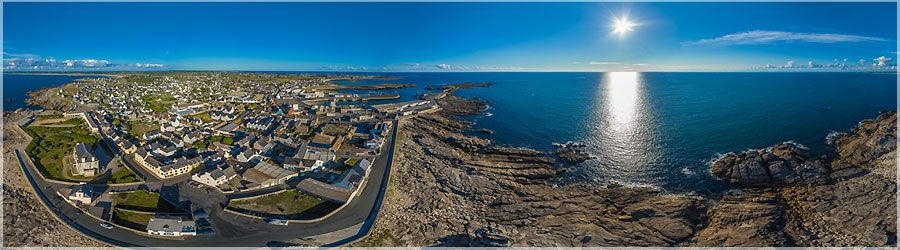
The tragedy of October 10, 1870 : that day, the prefect of Dinitère, Gustave Levainville comes picnic with family on the highest rock of St. Guénolé : a breaking wave carries his wifr, daughter and made three other victimes his family. A cross was sealed in the rock to commemorate this tragedy; laments of the time captured this news item concerned and the rock became know as 'Rock of victims' or 'Rock the Prefect'.
Panorama made of 12 x 3 photos taken on the 21 August 2014.
Click on the image to view the 360º panorama ! 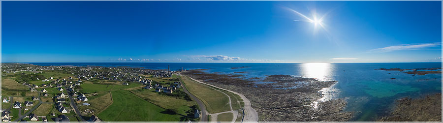
The Chapel of Our Lady of Joy was built in the 15th to the sea, behind a dike that protects its fury. Indeed, the storm of December 1896 was then ripped the doors, removed the dam and water flooded the chapel up to 50 centimeters in height! Calvary Chapel in front is dated 1588 The roof was completely renovated in 1998 and carvings have been discovered then.
Panorama made of 12 x 3 photos taken on the 21 August 2014.
Click on the image to view the 360º panorama ! 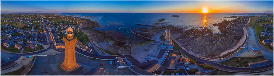
Sunset on the lighthouse Eckmühl in Finistere
Panorama made of 12 x 3 photos taken on the 18 August 2014.
Click on the image to view the 360º panorama ! 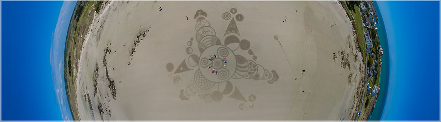
The Tourist Office of Penmarch offers during the summer workshops Land Art on the beach of Pors Carn. Making art in and with nature! The beach as blank canvas, equipped with simple tools, your imagination no limit ... Be the artists has a collective work and ephemeral!
Panorama made of 12 x 3 photos taken on the 15 August 2014.
Click on the image to view the 360º panorama ! 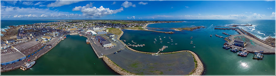
St. Guénolé is the northwest area og the town of Penmarch in Bigouden, in Brittany. Important fishing port, it is in 2012 the fifth fishing port of France in tonnage, and the fourth sardine port of France.
Panorama made of 12 x 3 photos taken on the 12 August 2014.
Click on the image to view the 360º panorama ! 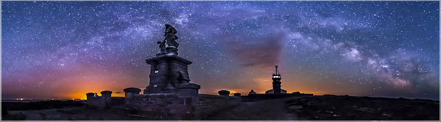
The Milky Way to the Pointe du Raz. It was around 3:00 am when these photos were taken!
Panorama made of 12 photos taken on the 29 May 2014.
Click on the image to view the 360º panorama ! 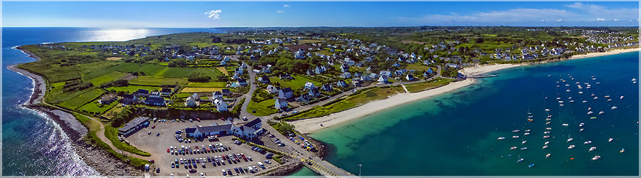
For a demonstration of aerial photography, we went on the Esquibien port. Here is the aerial view of Esquibien port, embarquadère the boat to the island of Sein.
Panorama made of 11 photos taken on the 28 May 2014.
Click on the image to view the 360º panorama ! 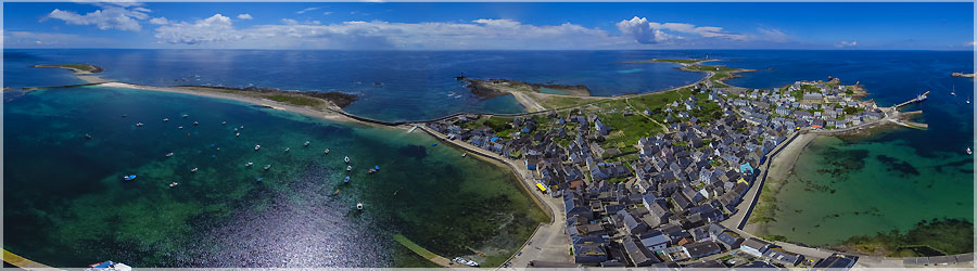
Here is the second aerial view on the island of Sein.
Panorama made of 10 photos taken on the 26 May 2014.
Click on the image to view the 360º panorama ! 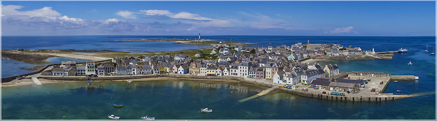
During an excursion on the island of Sein, I realized this first image above the port. The wind was very small, I even wet my line!
Panorama made of 10 photos taken on the 26 May 2014.
Click on the image to view the 360º panorama ! 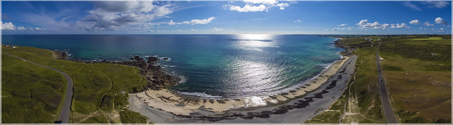
An aerial view of the beach beside Gwendrez Plouhinec.
Panorama made of 10 photos taken on the 25 May 2014.
Click on the image to view the 360º panorama ! 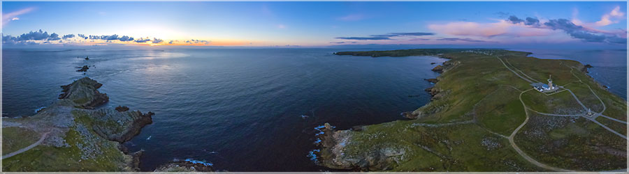
I made this photo just after sunset. The colors are still bright, the brightness is soft.
Panorama made of 12 photos taken on the 25 May 2014.
Click on the image to view the 360º panorama ! 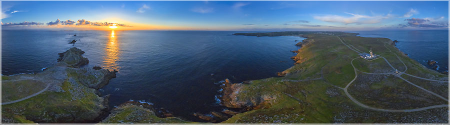
The wind was very low during the sunset. So I pulled out my big Delta 5.5 m² to get them to steal my camera. The wind was light but steady! A treat!
Panorama made of 12 photos taken on the 25 May 2014.
Click on the image to view the 360º panorama ! 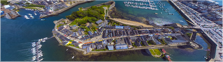
Concarneau is a city located in Finistère, in the Brittany region. The city was formed in the Middle Ages from the walled city located in the estuary of the Moros: this natural shelter has allowed the development of the seventh French fishing port in tonnage landed and important shipyards. Its location on the coast and its historical heritage have made it a tourist destination Breton foreground. Currently, this is the third town in the Finistère by its population.
Panorama made of 9 photos taken on the 07 May 2014.
Click on the image to view the 360º panorama ! 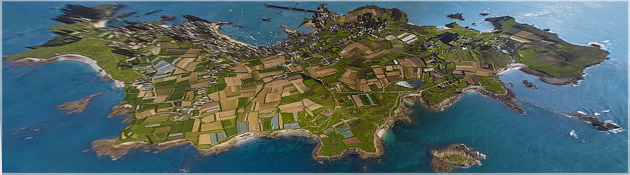
The island of Batz is a French island, part of the Iles du Ponant. It is located in northern Finistère, separated by a channel of Roscoff 2km (15min journey). It is 3.5 km long, 1.5 km wide, and the tower is nearly 14Km. Found on the side of many sandy beaches. The climate is mild and oceanic, and benefiting from the Gulf Stream, the cultures are very diverse.
Panorama made of 11 photos taken on the 29 April 2014.
Click on the image to view the 360º panorama ! 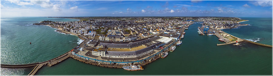
The port comprises several ports Guilvinec bigouden countries: Guilvinec, Saint-Guénolé, Benodet, and Lesconil Loctudy. This group is the largest in France, which takes into account the number of seafarers (about 1000 sailors) or the value of goods sold (3,000 jobs created by the fishing industry, between auctions, fish trading companies , shipyards, canneries, bowsers ...). This port is set into production almost 20% of the French fishing! If we carefully observe the image, you can see above the blue line a crowd of tourists: in fact, it is above the auction and the landing zone, and then observed the arena of small cranes landed the fish without bothering or interfere fishermen!
Panorama made of 12 photos taken on the 28 April 2014.
Click on the image to view the 360º panorama ! 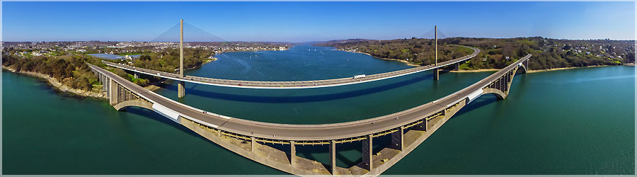
This time, I used the kite 4m for takeoff. The wind is really weird on the bridge on both sides, you feel the wind in your face! There are sacred remoux takeoff, but it stabilizes when given a few lines!
Panorama made of 12 photos taken on the 12 April 2014.
Click on the image to view the 360º panorama ! 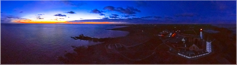
For the last two views, I'm a little disappointed because I think I really accomplish a given limits of my camera / lens couple I am limited by the opening 3.5 fisheye, I am limited by the speed of shooting not have camera shake, and I am limited by the rise of small Iso E-pm1
Panorama made of 12 photos taken on the 12 April 2014.
Click on the image to view the 360º panorama ! 
4 panoramic images were taken at exactly the same distance (in wire length) ... By me against the wind was not great constant, so the camera is not exactly the same place on different shots ... Some numbers: It was 12 ° C when I started this session, and 7 ° C when I packed up, but the feeling should be slightly lower with the constant wind ... I used 2 batteries for my car, and 2 batteries for the camera. I brought 1,850 photos, to exit 4 panoramas!
Panorama made of 12 photos taken on the 12 April 2014.
Click on the image to view the 360º panorama ! 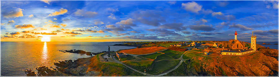
A little wind, but allows you to fly my pod with the delta graphic rainbow 3m wide. No need to leave large delta nor rokkaku ... Especially that I have in mind to take pictures after sunset, so it should not be too much hassle to store, because overnight, can quickly lose something in the dark ...
Panorama made of 12 photos taken on the 12 April 2014.
Click on the image to view the 360º panorama ! 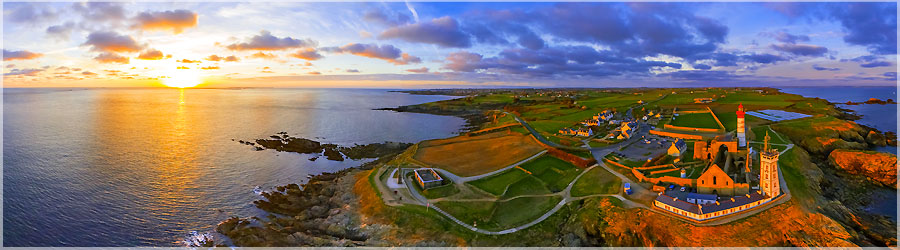
I went for a ride to the Pointe Saint Mathieu (near Brest), to try to make an aerial view of the sunset over the sea I look at my blue hour calculator to know what time will the sunset sun, hop, 45 minutes by car, and I am there! I arrive 25 minutes before sunset, ideal for taking the time to install, unpack all the hardware, and do tests on what kite choose depending on the wind!
Panorama made of 12 photos taken on the 12 April 2014.
Click on the image to view the 360º panorama ! 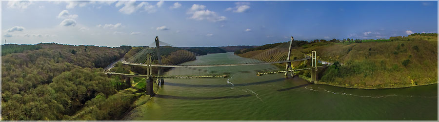
Deconstruction of the old bridge Térénez (1952). The old bridge is suffering from 'concrete cancer', it was decided in 2013 to demolish. As the site is classified Natura 2000, everything should be recycled, and nothing should get in the water! Towers on each bank will be preserved and transformed into viewpoints. The construction began in January 2014, and now we can see the cutting deck ... Do not tell me there was an assembly error on the bridge deck !
Panorama made of 12 photos taken on the 30 March 2014.
Click on the image to view the 360º panorama ! 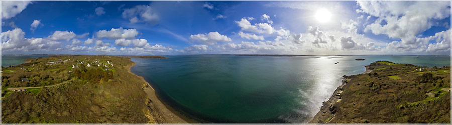
The tip of Brittany is located at the western end of the peninsula of Plougastel. It is part of the municipality of Plougastel-Daoulas and faces Long Island.
Panorama made of 12 photos taken on the 23 March 2014.
Click on the image to view the 360º panorama ! 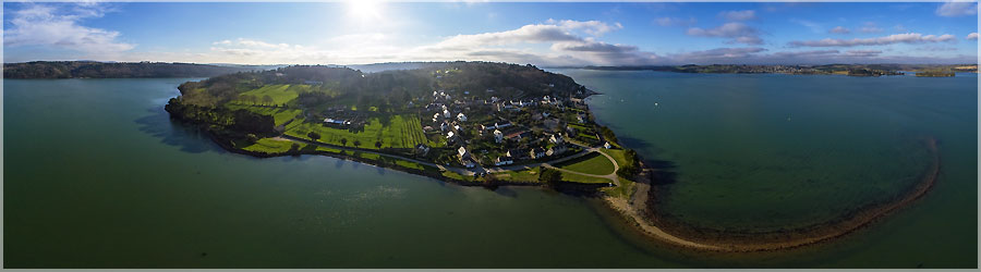
Luckily I had brought my giant delta kite! The wind was very low, and would not have allowed me to take the camera with conventional kites ... Landevennec is located at the mouth of Alder in the harbor of Brest, near the cemetery boats ... This are the smallest municipality in the Crozon peninsula.
Panorama made of 12 photos taken on the 15 March 2014.
Click on the image to view the 360º panorama ! 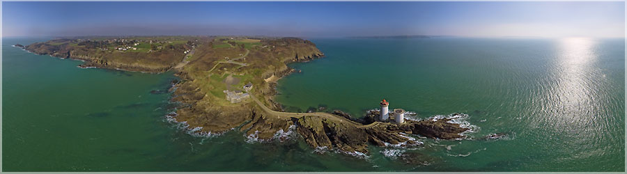
Petit Minou lighthouse is built on an advanced sea rock on the north coast of Brest Channel. It shows the way forward to enter the harbor, forming an alignment with the lighthouse Portzic. It peaks at 26m above the ground, 34m above the sea was lit in 1848 and fully automated in 1989, and has since controlled from Brest. Its range is about 35km.
Panorama made of 10 photos taken on the 11 March 2014.
Click on the image to view the 360º panorama ! 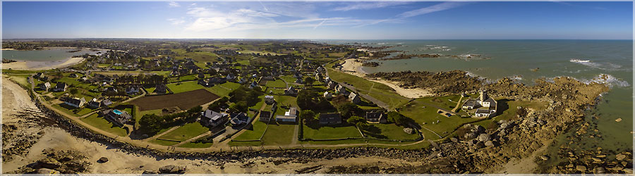
Here is a closer view of the semaphore. But the delta really moved too so I tried an earlier and less lofty view. Maybe Andre and Hervé have succeeded? In any case, for me, the wind was not stable enough: caution! This semaphore is a semaphore 50 distributed on the French coast: a strategic point in coastal surveillance by the Navy.
Panorama made of 8 photos taken on the 09 March 2014.
Click on the image to view the 360º panorama ! 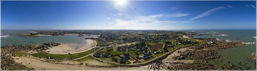
And here the last two aerial photos of sunny Sunday. A global view of the beach with Brignogan after the semaphore. This is a track I like, with huge rocks all round, it's nice to walk! The semaphore was built in 1980 to replace the Aber Wrach. Note that it is perfectly integrated into the huge boulders overlooking the shore, with a "skin stone."
Panorama made of 6 photos taken on the 09 March 2014.
Click on the image to view the 360º panorama ! 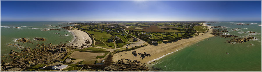
After taking a picture Meneham home, we went next to the lighthouse Pontusval. The wind was a little put on weight, enough that I sort the rokkaku. I have not had too much trouble to return it, I was smack bang in the wind range! This lighthouse stands on Pontusval tip Beg Pol, next to the beaches of Brignogan. It was built after many shipwrecks, it serves as a bridge between the headlights Virgin Island and the Isle of Wight.
Panorama made of 8 photos taken on the 09 March 2014.
Click on the image to view the 360º panorama ! 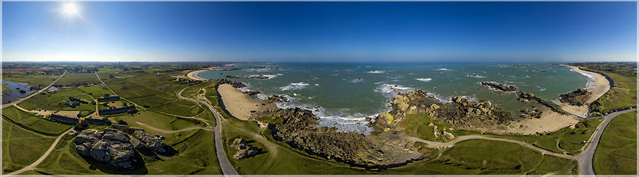
2/2 This weekend , it was fine (finally) , and there was a little wind! While André Hervé and we have given ourselves an appointment on the north coast of Finistere. We started by taking a picture of a small house wedged between two boulders in Meneham. But in the morning , there really was not much wind. Luckily I finished building my giant delta , otherwise I would not have been able to steal my boat ... I also do not like light winds , because I am obliged to use anything other than the rokkaku , and it is ultimately the most stable for my practice of photography, that is to say to air panoramic ... the deltas are my most practical way to implement , but I is good players to go right , left, following the wind ... So, for the assembly, it is much more complicated. It finds herself with a horizon which plays a roller coaster ! So here are two views made a few minutes apart. The first , André went to tell me where the camera was over the house, and I was almost at the top. While on the second , the camera is a bit remote , it is higher, and can be seen well before the house.
Panorama made of 7 photos taken on the 09 March 2014.
Click on the image to view the 360º panorama ! 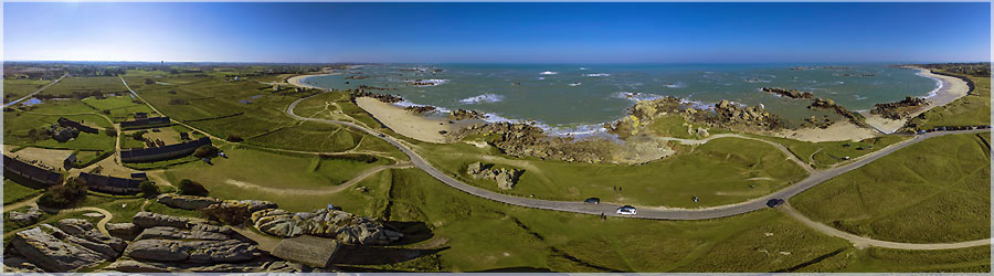
1/2 This weekend , it was fine (finally) , and there was a little wind! While André Hervé and we have given ourselves an appointment on the north coast of Finistere. We started by taking a picture of a small house wedged between two boulders in Meneham. But in the morning , there really was not much wind. Luckily I finished building my giant delta , otherwise I would not have been able to steal my boat ... I also do not like light winds , because I am obliged to use anything other than the rokkaku , and it is ultimately the most stable for my practice of photography, that is to say to air panoramic ... the deltas are my most practical way to implement , but I is good players to go right , left, following the wind ... So, for the assembly, it is much more complicated. It finds herself with a horizon which plays a roller coaster ! So here are two views made a few minutes apart. The first , André went to tell me where the camera was over the house, and I was almost at the top. While on the second , the camera is a bit remote , it is higher, and can be seen well before the house.
Panorama made of 6 photos taken on the 09 March 2014.
Click on the image to view the 360º panorama ! 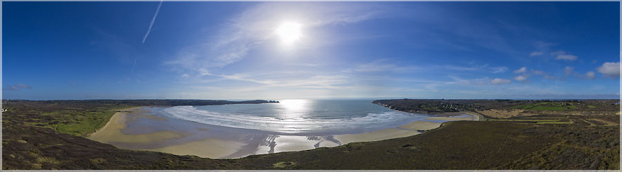
First flight with Delta 4m. It can take off in very low wind.
Panorama made of 8 photos taken on the 05 March 2014.
Click on the image to view the 360º panorama ! 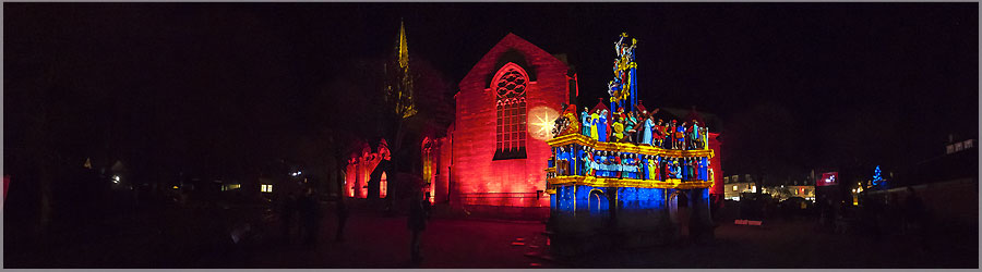
Another restoration took place from November 2003 to March 2004. The work involved the complete removal, cleaning and restoration of the base and all the statuary, including the repair of broken stones and repair of seals.
Panorama made of 13 photos taken on the 19 December 2013.
Click on the image to view the 360º panorama ! 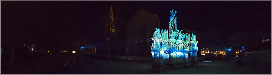
23 August 1944, during the American advance towards Brest, it was damaged by U.S. bombing. Calvary is hit by shells and several statues are destroyed and the three crosses. John D. Skilton, but conservative American Museum of Washington officer in civilian life, this Plougastel-Daoulas at the time of the bombing, put away the statues and stone chips and created in his country Plougastel Calvary Restoration Fund Inc to raise the funds needed to restore the ordeal. The work is performed under the direction of Department of Fine Arts and Historical Monuments in 1949 by sculptor Millet.
Panorama made of 13 photos taken on the 19 December 2013.
Click on the image to view the 360º panorama ! 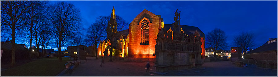
Three steps documented marked its construction: 1602 completion of the base. 1603: completion and installation of three crosses. 1604: total completion of the monument with all statuary.
Panorama made of 13 photos taken on the 20 December 2013.
Click on the image to view the 360º panorama ! 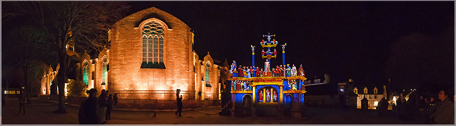
Tradition and history make the ordeal Plougastel-Daoulas a votive offering in 1598 marking the end of the plague that had decimated a third of the population of the peninsula. The Lord of Kererault died September 27, 1598 by the wish that ordeal is built as a votive offering if the latter died of the plague.
Panorama made of 13 photos taken on the 19 December 2013.
Click on the image to view the 360º panorama ! 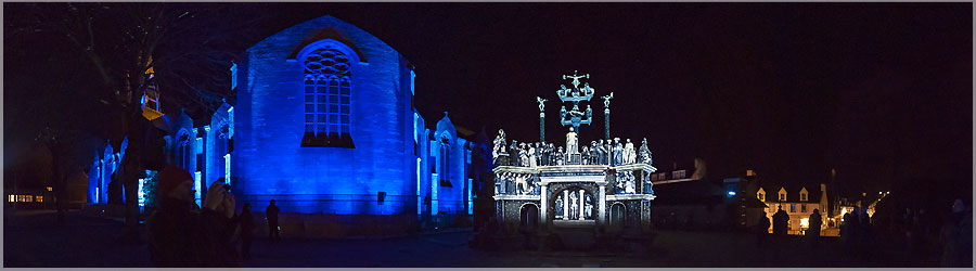
From the simplest to the most complex, crosses, like chapels iconographic scheme, enliven the community devotional landscape telling the Passion of Christ, Mary's pain and comfort of local patron saints. Breton, was appointed Kalvar Plougastell-Daoulaz or Kroaz ar vossen or literally 'cross the plague.'
Panorama made of 13 photos taken on the 19 December 2013.
Click on the image to view the 360º panorama ! 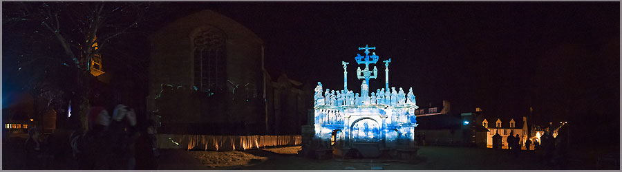
Calvary is located in the town center Plougastel-Daoulas (Finistère), south of the parish church of St. Peter was rebuilt in 1950. The territory of Plougastel-Daoulas is characterized by the presence of 26 crosses placed along the path that for many coastal areas or major roads in the region converge on the town.
Panorama made of 13 photos taken on the 19 December 2013.
Click on the image to view the 360º panorama ! 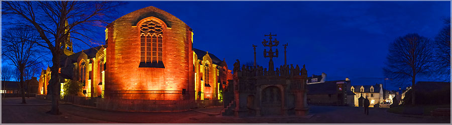
Calvary is a Calvary Plougastel built between 1602 and 1604 as a votive offering to the cessation of the plague in 1598. It was a historical monument in 1889
Panorama made of 13 photos taken on the 20 December 2013.
Click on the image to view the 360º panorama ! 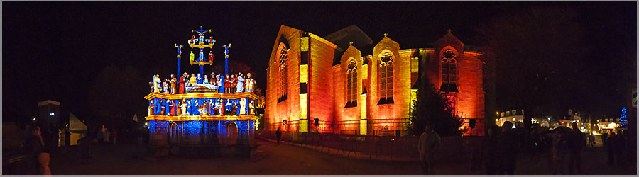
The shrines built mostly between the sixteenth and the seventeenth century, were erected during the golden age of Britain.
Panorama made of 13 photos taken on the 19 December 2013.
Click on the image to view the 360º panorama ! 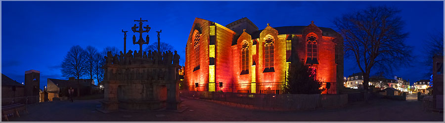
Association 7 monumental shrines of Brittany offers beautiful illuminations 7 crosses in Britain.
Panorama made of 13 photos taken on the 20 December 2013.
Click on the image to view the 360º panorama ! 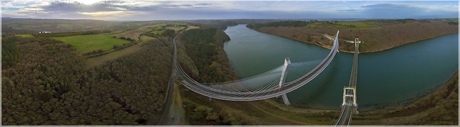
The bridge spans the Térénez Argol between Alder and Rosnoën the 791 road which connects the Crozon Faou. It is located in Brittany and is considered an essential element for opening the Crozon peninsula , if you do not want to make a detour of 47 km to go through Châteaulin to reach the North Finistère. Before the bridge , crossing the Alder was through bins to ensure the continuity of the road. Accidents were numerous , especially on fair days due to a flat-bottomed tray and maneuverable little that was swept away by the current of the tides and capsized. Alder swallowed up men, horses and goods. Bridge 1925 : The first bridge was built Térénez between 1913 and 1925. It was suspended from a length of 350 m, 272 m to the main span bridge. On 13 December 1925, he was open to traffic and has been , at the time, the largest bridge in Europe. This bridge was destroyed Térénez August 24, 1944 by the German army in order to delay the advance of the Allied troops witnesses say it was destroyed by American bombing , at the same time that they bombed the city Telgruc nearby. Bridge 1952 : The new bridge , based on its original batteries, not completed until 1952. It is a suspension bridge, like the previous one, which uses the same measurements: length 350 m, 272 m to the main span. This bridge is now suffering from " concrete cancer " ( alkaline reaction) since 1992 and is under close supervision. Bridge 2011: In 1998, the selected project towards a reconstruction of the bridge Térénez near the existing bridge. The major option is to provide access to improve traffic flow curve. On the bridge of 1951, the access right angle does not allow the crossing of a semi- trailer and another vehicle , one to give way to another. The construction began on 19 April 2007. Boxes anchor stays at the top of the pillars were respectively hoisted 7 July 2009 on the left bank ( Argol side of the peninsula ) and 13 January 2010 on the right bank ( side Rosnoën ). The first half of the structu
Panorama made of 12 photos taken on the 14 December 2013.
Click on the image to view the 360º panorama ! 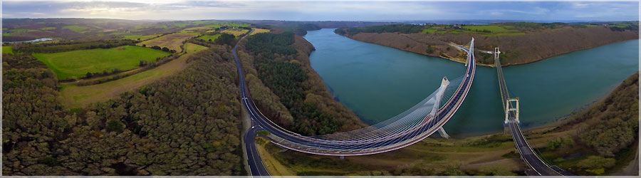
The bridge spans the Térénez Argol between Alder and Rosnoën the 791 road which connects the Crozon Faou. It is located in Brittany and is considered an essential element for opening the Crozon peninsula , if you do not want to make a detour of 47 km to go through Châteaulin to reach the North Finistère. Before the bridge , crossing the Alder was through bins to ensure the continuity of the road. Accidents were numerous , especially on fair days due to a flat-bottomed tray and maneuverable little that was swept away by the current of the tides and capsized. Alder swallowed up men, horses and goods. Bridge 1925 : The first bridge was built Térénez between 1913 and 1925. It was suspended from a length of 350 m, 272 m to the main span bridge. On 13 December 1925, he was open to traffic and has been , at the time, the largest bridge in Europe. This bridge was destroyed Térénez August 24, 1944 by the German army in order to delay the advance of the Allied troops witnesses say it was destroyed by American bombing , at the same time that they bombed the city Telgruc nearby. Bridge 1952 : The new bridge , based on its original batteries, not completed until 1952. It is a suspension bridge, like the previous one, which uses the same measurements: length 350 m, 272 m to the main span. This bridge is now suffering from " concrete cancer " ( alkaline reaction) since 1992 and is under close supervision. Bridge 2011: In 1998, the selected project towards a reconstruction of the bridge Térénez near the existing bridge. The major option is to provide access to improve traffic flow curve. On the bridge of 1951, the access right angle does not allow the crossing of a semi- trailer and another vehicle , one to give way to another. The construction began on 19 April 2007. Boxes anchor stays at the top of the pillars were respectively hoisted 7 July 2009 on the left bank ( Argol side of the peninsula ) and 13 January 2010 on the right bank ( side Rosnoën ). The first half of the structu
Panorama made of 12 photos taken on the 14 December 2013.
Click on the image to view the 360º panorama ! 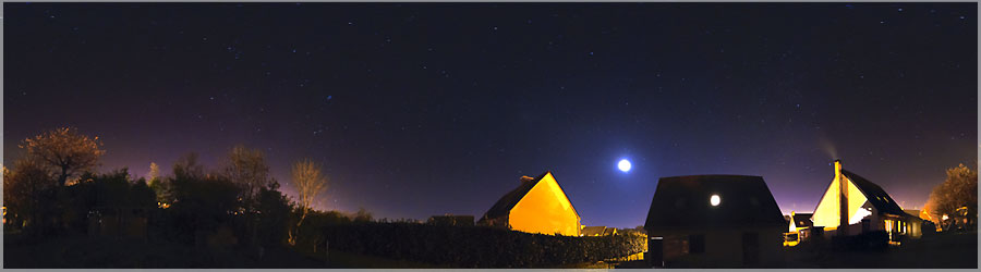
I try to picture 360° panoramic night... This is handy in winter, the sun sets early! We see the major constellations, as well as light pollution and Brest Plougastel... However, there is still some way before arriving at a correct result, in particular the management of noise on the small GF1, with breaks of 20s to 200iso!
Panorama made of 13 photos taken on the 09 December 2013.
Click on the image to view the 360º panorama ! 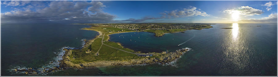
The name of Plouarzel comes from the word Breton lann ('monastery'), and Paol: Saint Pol Aurélien, which was added the suffix 'Plouarzel', the name of the nearby town, to differentiate the common other 'lampaul ', among other Lampaul-Ploudalmézeau. The town is enclosed in the Plouarzel. It is located about 25 km west-northwest of Brest. It has two ports, one in deep water. From a geological point of view, the region is rich in Hercynian granites where you can find older xenoliths, which can be observed more closely to the coast.
Panorama made of 11 photos taken on the 01 December 2013.
Click on the image to view the 360º panorama ! ![Vue aérienne de l'entrée du port de Lanildut Lanildut est une commune du département du Finistère, dans la région Bretagne, en France. Lanildut vient de lann (ermitage en breton) et de Ildut (saint gallois du ve siècle). Avec l'apparition des engrais chimiques, la question de l'avenir des goémoniers s'est posée depuis les années 19602, mais Lanildut reste le premier port goémonier d'Europe, avec 35 000 tonnes d'algues déchargées sur ses quais chaque année, soit presque la moitié de la production nationale du goémon. [ Le soubassement (environ 100 tonnes) de l'obélisque de Louksor, érigé en 1836, sur la place de la Concorde à Paris, provient des carrières de granit de l'Aber-Ildut.] www.360x180.fr Selme Matthieu](medias/spheriques/france/29/509-kap_entree_port_lanildut/kap_entree_port_lanildut.jpg)
Lanildut is a commune in the Finistère department in Brittany, France. Lanildut just Lann (hermitage in Breton) and Ildut (Welsh saint of the fifth century). With the advent of chemical fertilizers, the question of the future of seaweed has arisen since the 19602, but the rest Lanildut goémonier first port in Europe, with 35 000 tons of algae unloaded on the quays every year almost half of the domestic production of seaweed. [The basement (about 100 tonnes) of the Obelisk of Luxor, built in 1836, on the Place de la Concorde in Paris, from granite quarries Aber Ildut.]
Panorama made of 11 photos taken on the 01 December 2013.
Click on the image to view the 360º panorama ! 
Cenotaph Pointe Saint-Mathieu, part of the national memorial to the dead Marine France, located in the town of Plougonvelin. It welcomes 100,000 visitors each year.
Panorama made of 6 x 12 x 3 photos taken on the 14 October 2013.
Click on the image to view the 360º panorama ! 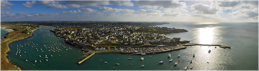
Conquet is a French commune in the department of Finistère, in the Brittany region. It is the westernmost town in mainland France. Port significant crab, Conquet also became a place of production known for the noble fish. In recent years, the fleet has diversified its activities alongside traditional potters fishing for crab grew netters who bring monkfish, skate, brill, turbot and lobster and fish small fish, fresh daily. Nevertheless meal remains the symbol of the port side of the world.
Panorama made of 11 photos taken on the 17 November 2013.
Click on the image to view the 360º panorama ! 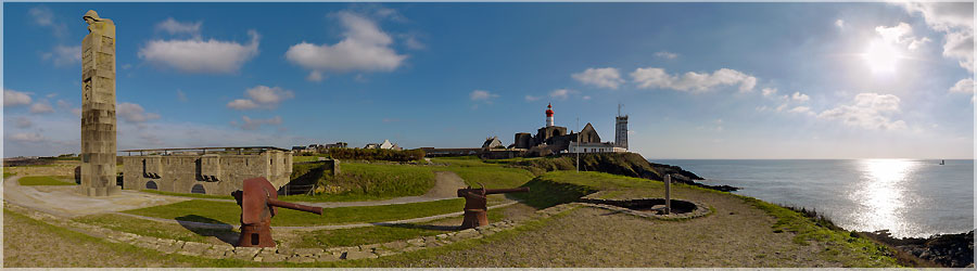
Pointe Saint-Mathieu is a tip of Finistère nearby Conquet the territory of the commune of Plougonvelin. It is lined with cliffs surrounding 20 meters.
Panorama made of 12 x 3 photos taken on the 17 November 2013.
Click on the image to view the 360º panorama ! 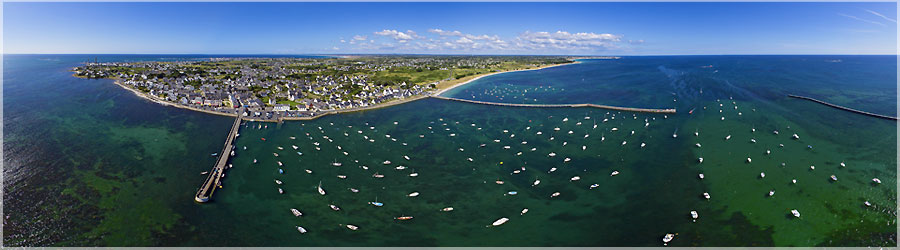
Kérity is a district of the municipality of Penmarc in Bigouden, as well as St. Peter and St. Guénolé Penmarc'h-Bourg (formerly Tréoultré). Wearing Kérity is now facing the home of yachting, after the departure of the last boats to the nearby fishing port of Saint-Guénolé in the late 1990s.
Panorama made of 11 photos taken on the 19 August 2013.
Click on the image to view the 360º panorama ! 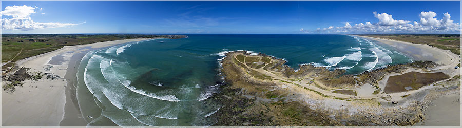
The tip of the torch (Beg DORCHENN in Breton) is a natural peninsula barring the southeastern tip of the Bay of Audierne, in the municipality of Plomeur in Bigouden in Finistere, Brittany. This headland keeps the footprints of a human presence in the Mesolithic (Shelly clusters) and Middle Neolithic (dolmen). The lake is very popular with sports fans.
Panorama made of 11 photos taken on the 18 August 2013.
Click on the image to view the 360º panorama ! 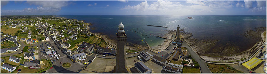
Eckmühl lighthouse is a lighthouse located on the edge of St. Pierre, Penmarch, in Brittany in France. It measures more than 60 meters high. It was inaugurated October 17, 1897 and is named after the noble title of the donor who largely funded. It secures one of the most dangerous coastlines in France because of its many reefs. Its walls are built entirely of granite Kersanton and the inner wall of the staircase is covered with opaline plates. It is now one of the most visited monuments of Finistère. The lighthouse is the subject of a classification as historical monuments since May 23, 2011.
Panorama made of 11 photos taken on the 18 August 2013.
Click on the image to view the 360º panorama ! 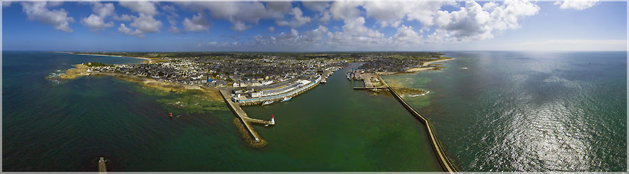
Guilvinec is a commune in the Finistère department in Brittany. Its official name is French "Guilvinec" even if the use of the name "The Guilvinec" is very widespread as in the Breton town is called "Ar Gelveneg." The town is the capital of a canton, with those Plogastel-Saint-Germain and Pont l'Abbé, as the entity tradition Bigouden. Capital of the maritime area which bears his name in 2012 Guilvinec is the first fishing port in France of French boats landed value : The fleet consists of 101 ships (the canoe trawler) to 415 marins. Guilvinec common shares with the neighboring town of Treffiagat Léchiagat-largest fishing port in France.
Panorama made of 11 photos taken on the 18 August 2013.
Click on the image to view the 360º panorama ! 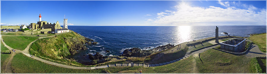
Output by a low wind less than 10 knots and very shaving, at ground level : if I let more than 80m of wire, the kite fell ! The view has been made as high as possible with the Rokkaku... We'll have to think about buildinf a kite bigger...
Panorama made of 7 photos taken on the 07 September 2013.
Click on the image to view the 360º panorama ! 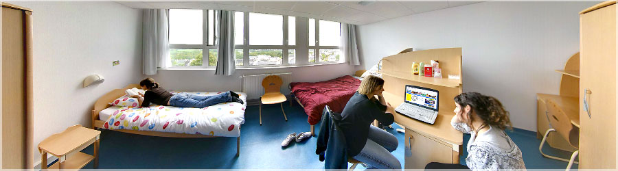
Virtual tour of the boarding school cited Jean-Marie Le Bris, composed of three 360 ° panoramas. It includes a bedroom, 2 study room.
Panorama made of 12 x 3 photos taken on the 29 April 2009.
Click on the image to view the 360º panorama ! 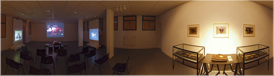
Roland achieved a remarkable work, entitled 3BOOKS. It presents a series of three videos, completely original. A see absolutely!
Panorama made of 12 x 3 photos taken on the 11 April 2013.
Click on the image to view the 360º panorama ! 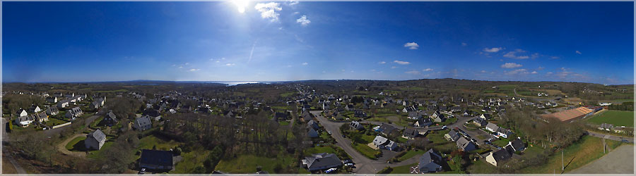
Loperhet is a town located in the Finistère department of Brittany. Surrounded by common Dirinon, Daoulas Plougastel-Daoulas Loperhet is located 9 km southwest of Landerneau and fifteen km south of Brest. The common Loperhet ends south at the tip of Tostiviec, located at the mouth of the river Daoulas. The village is located 58m but finage communal varies from 162m to sea level. The oldest document mentioning Loperhet date of 1186, this is the confirmation Hervé I de Léon (Lord Leo) instead of a donation made by his father Guyomarch IV Leo and his mother Nobilis (Nobile) canons Regulas of the abbey of Notre-Dame Daoulas. The name of the town comes from Loc Perhet, oratory Perhet ing (or Berc'hed ing, also know as St. Bridget).
Panorama made of 7 photos taken on the 06 April 2013.
Click on the image to view the 360º panorama ! 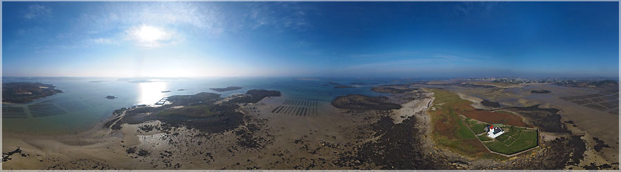
This lighthouse is currently exhibiting works regularly and is open to the public. This differs from the previous panoramic altitude shooting. Here 150m line were held, the camera should be around 80-90m above the ground.
Panorama made of 6 photos taken on the 04 March 2013.
Click on the image to view the 360º panorama ! 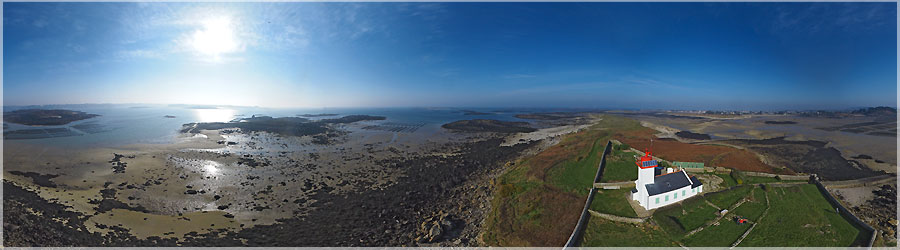
This small lighthouse is accessible by foot only around low tide, more or less 3 hours. We must plan the shot and not getting caught up on the small island... For panoramic, I place little line, so you can see the lighthouse. The camera should be around 25-30m above the ground.
Panorama made of 6 photos taken on the 04 March 2013.
Click on the image to view the 360º panorama ! 
Blue sky and the wind? Northern Finistère direction for a small KAP session. I started this afternoon by shooting aerial peninsula Saint Marguerite. The wind is sustained between 10km/h and 15km/h, which is sufficient to raise a pod 700g, with a rokkaku 2m.
Panorama made of 6 photos taken on the 04 March 2013.
Click on the image to view the 360º panorama ! 
At the end of the day, the sun is quite low, so check the settings of the camera to not have pictures overexposed because of the huge sun's reflection in the water...
Panorama made of 6 photos taken on the 17 February 2013.
Click on the image to view the 360º panorama ! 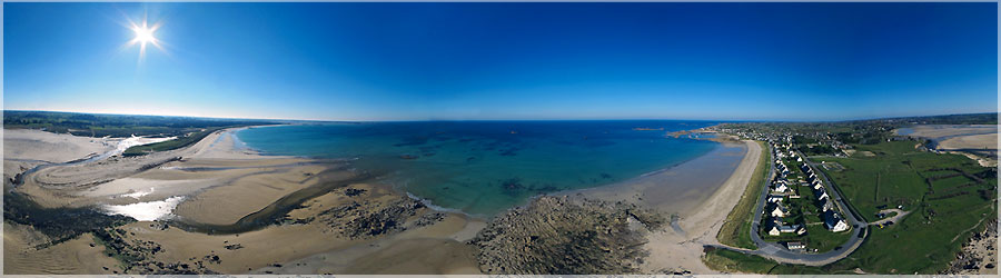
A wind of 11-12 knots, and here is the handle beside Kernic Plouescat made kite !
Panorama made of 6 photos taken on the 17 February 2013.
Click on the image to view the 360º panorama ! 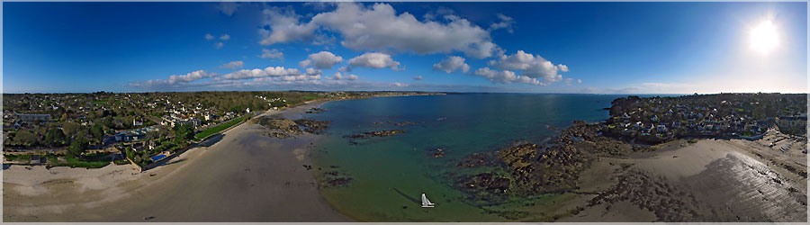
I just received my new Rokkaku kite (hexagonal), the colors of my logo! I have also just finished my pod optimized 700g (apn + lens + battery + cradle + radio + Picavet) against 1200g for the former: it allows me to move in lighter winds!
Panorama made of 6 photos taken on the 16 February 2013.
Click on the image to view the 360º panorama ! 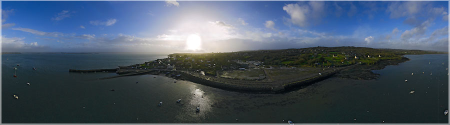
Tinduff harbour
Panorama made of 6 photos taken on the 16 December 2012.
Click on the image to view the 360º panorama ! 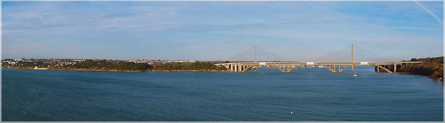
Aerial view of the bridge Louppe Albert Brest.
Panorama made of 6 photos taken on the 12 December 2012.
Click on the image to view the 360º panorama ! 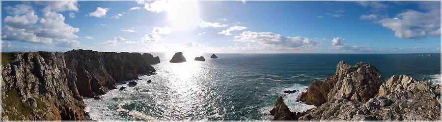
Confident enough in my previous outings, I decided to make a panoramic view over the Pen Hir, and Tas de Pois. I launch the kite, which lost on the pitch, to finish in the rocks! I check the settings, and decides to raise. It flies much better, so I hung the basket and the camera. I let a little line to get it all, and enjoy a good view high above the cliffs. Unfortunately, the wind calmed down a bit, and it must be around 7-8 knots. It is not sufficient for this type of kite, especially with a gondola suspended below 1.2 kg. The kite loses altitude, and finds himself in a non-windy (just above the water, protected by cliffs). No longer swollen, it folds and falls like a leaf! I somehow back line, but that does not... The nacelle lands safely in the rocks against low-and kite a bit further. I gently down to go get materials... Fortunately, I recovered without any problems, and here's a view, not high enough for my taste, the Pen-Hir. The aerial photo is a risky business: no breach of trust!
Panorama made of 6 photos taken on the 11 November 2012.
Click on the image to view the 360º panorama ! 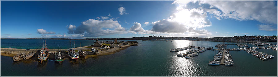
The small port of Camaret is fairly protected from the wind. The ground, the wind is very light, just a little breeze. We must be patient to take off the kite, and it takes a bit of altitude. A little higher, the winds are not much stronger, but fairly constant. So I decided to hook my pod and the camera, and drops a few lines. Then you can enjoy a nice view over the boats, and we discover the port of Camaret an unusual angle!
Panorama made of 5 photos taken on the 11 November 2012.
Click on the image to view the 360º panorama ! 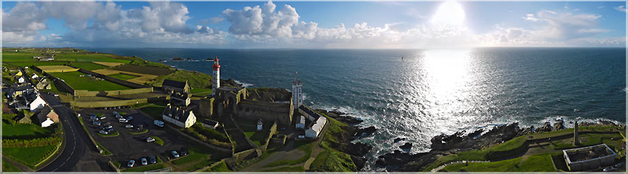
I went a little kite on the side of Pointe Saint Mathieu: Far West France... The wind was expected to be between 10 and 12 knots, but I suspect expected to be slightly below the reality, because I had a lot of difficulties to bring the kite: sore arm! I unpack equipment, install the camera on his car, make some adjustments aperture and shutter speed, then I prepare my kite. I look at the sky clear above my head, cloudy on the sides, then I look at the horizon... A white veil, foggy, fluffy on the sea, it is not a good sign at all! This means that within a few minutes, I would be soaked! Fortunately, the car is not far away, I pack all the equipment, and I wait a few minutes. Indeed, a good shower of rain mixed with hail is happy to interrupt my little output. 10 minutes later, blue sky, storm clouds are all gone. I therefore kite, but the clouds are gone, the tourists have returned... I pack the kite and walk a bit, not to have people in the legs... I did not want to take risks with the car and passersby! Especially as the wind was quite bizarre: the kite was doing well, but he had the tendency to lean to one side, gusts from the north pushed him to the ground! So I went to put me in a field not far from Saint Mathieu lighthouse like this, if everything fell, there was no damage! Here is the view taken about 80-85m high.
Panorama made of 6 photos taken on the 10 November 2012.
Click on the image to view the 360º panorama ! 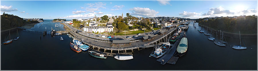
With Andre, we reach Sylvain Douarnenez. The weather was cloudy, light wind, but the forecast is rather reassuring clear of clouds, wind and a little more consistent at the end of the day. This is indeed the case, and we enjoy the wind a little stronger, to hang two nacelles under the same kite! (a Rokkaku, hexagonal) is the Rokkaku kite in its wind range is much still a Flow Form. The assembly of the pan will be much easier...
Panorama made of 6 photos taken on the 06 November 2012.
Click on the image to view the 360º panorama ! 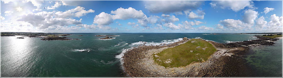
During a walk along the coast of North Finistère, i wanted to make a panorama on a small island. Except that the time to get there, and launch the kite and then take pictures of the water was well mounted... We had the choice between staying on the island 12:00 or remove chaussurer and quickly through... We arrived on the shore well soaked!
Panorama made of 6 photos taken on the 27 October 2012.
Click on the image to view the 360º panorama ! 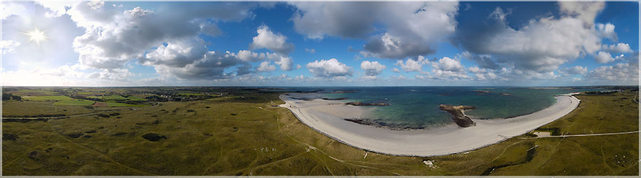
By a strong wind of 24 knots, gusting to 30 knots, the kite was stuck in the sky! So I took the opportunity to send the car and the camera to do this aerial view of dunes Ar Gazel.
Panorama made of 6 photos taken on the 27 October 2012.
Click on the image to view the 360º panorama ! 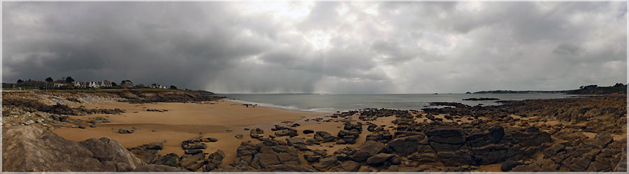
Beach of the Portez : the sky is threatening, quite dark gray, light difficult. Moments after the shooting, a downpour has flooded the floor...
Panorama made of 10 photos taken on the 23 March 2008.
Click on the image to view the 360º panorama ! 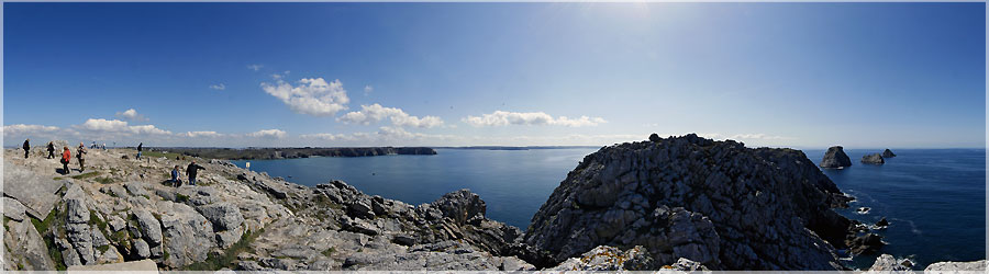
The Pen-hir is a tip of the peninsula of Brittany in Sligo. On a clear day you can see up to the Pointe du Raz and the island of Sein, and to the island of Ushant and the Pointe Saint-Mathieu. The steep cliffs, tall, with a level difference of about 70 meters with the Iroise, are therefore used for climbing.
Panorama made of 12 photos taken on the 15 April 2008.
Click on the image to view the 360º panorama ! 
At the end of the day, I decided to go do some aerial photos of the bay Lanveur.
Panorama made of 7 photos taken on the 05 September 2012.
Click on the image to view the 360º panorama ! 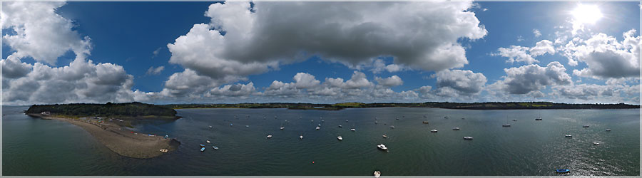
A light wind that did not allow climb as high as I wanted to make this Kersanton view port.
Panorama made of 7 photos taken on the 30 August 2012.
Click on the image to view the 360º panorama ! 
The wind was a little late in the day said, and I tried a panorama above the port Rostiviec. In the end, after talking with a passerby, my kite end his race in the water... I was not going to watch... Fortunately, the camera was recovered just before!
Panorama made of 7 photos taken on the 28 August 2012.
Click on the image to view the 360º panorama ! 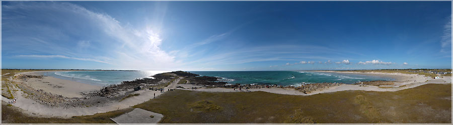
On the tip of the torch, the wind is weak, but I still try to send the car and his camera in the air...
Panorama made of 7 photos taken on the 23 August 2012.
Click on the image to view the 360º panorama ! 
First real attempt aerial view of 360 °. There are two major difficulties: first, successfully assemble a 360 ° without the connections are visible. The second, sending a camera into the air, and turn to take pictures all around him...
Panorama made of 8 photos taken on the 05 August 2012.
Click on the image to view the 360º panorama ! 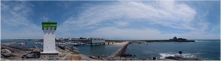
Artaud Castle, located at the tip of Trévignon is built on the site of ancient coastal fortifications, probably during the 4th quarter of the 19th century. The tip of Trévignon juts into the ocean south-west, and is the highest point south of the town.
Panorama made of 3 x 12 photos taken on the 17 May 2012.
Click on the image to view the 360º panorama ! 
A very pretentious...
Panorama made of 13 x 3 photos taken on the 21 February 2010.
Click on the image to view the 360º panorama ! 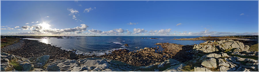
Beautiful blue sky on the tip of Porz Grac'h
Panorama made of 13 x 3 photos taken on the 24 January 2010.
Click on the image to view the 360º panorama ! 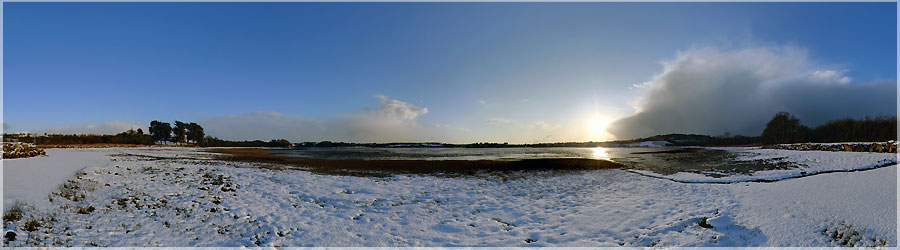
Snow in abundance (20-25 cm) in Britain in early 2010...
Panorama made of 13 x 3 photos taken on the 09 January 2010.
Click on the image to view the 360º panorama ! 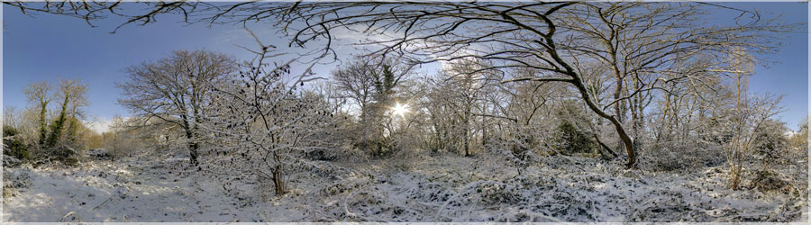
Snow-covered woods Loperhet
Panorama made of 3 x 10 photos taken on the 02 February 2009.
Click on the image to view the 360º panorama ! 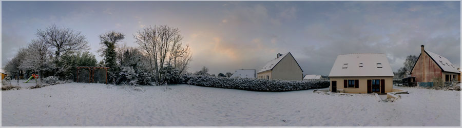
Snow in the garden in Loperhet
Panorama made of 3 x 11 photos taken on the 02 February 2009.
Click on the image to view the 360º panorama ! 
The abbey of Saint-Guénolé Landévennec Abbey is located in the municipality of Landévennec in the department of Finistère. It is deemed to have been founded in the fifth century by St. Guénolé, making it one of the oldest and largest of Britain. Abandoned in 1793, it is raised by a new Benedictine monastic community in 1958, who built new buildings.
Panorama made of 2 x 12 photos taken on the 19 October 2008.
Click on the image to view the 360º panorama ! 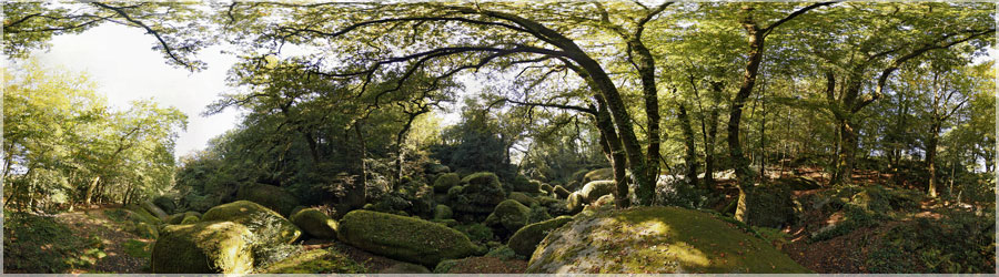
Huelgoat Forest
Panorama made of 11 photos taken on the 11 October 2008.
Click on the image to view the 360º panorama ! 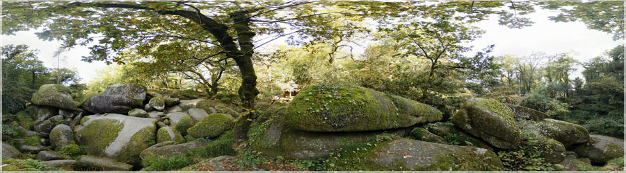
Huelgoat Forest, planted mainly oak and beech covers about 1000 hectares. Forest, it has long harbored clog, but it was ravaged by the hurricane of October 1987 and houses a remarkable granite chaos in the Valley of the Silver River primarily, and a series of natural sites with often strange rise to legends and stories...
Panorama made of 10 photos taken on the 11 October 2008.
Click on the image to view the 360º panorama ! 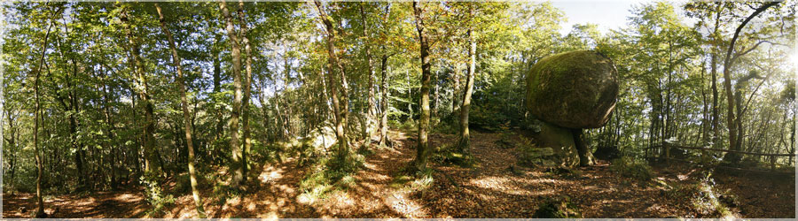
'The Mushroom' actually looks like a huge mushroom, but it is granite, and must weigh about 200 tonnes...
Panorama made of 16 photos taken on the 11 October 2008.
Click on the image to view the 360º panorama ! 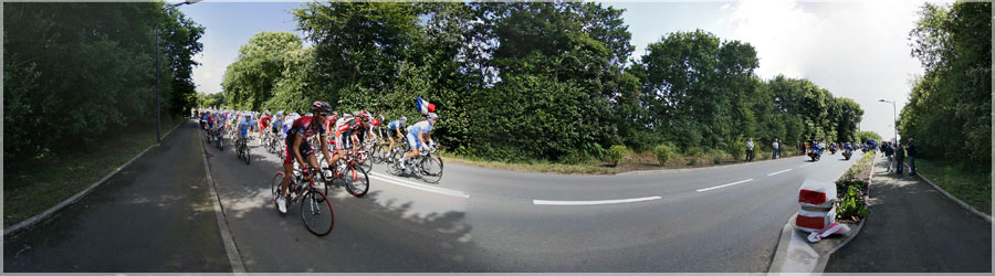
The 95th edition of the Tour de France was held from 5 to 27 July 2008. The race is part of Brest, and then went through the small village of Loperhet. It included 21 steps for a total length of 3 558.5 km.
Panorama made of 11 photos taken on the 05 July 2008.
Click on the image to view the 360º panorama ! 
Pointe Sainte-Anne in St Pol de Leon
Panorama made of 13 photos taken on the 16 April 2008.
Click on the image to view the 360º panorama ! 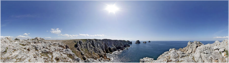
The Pen-hir is a tip of the peninsula of Brittany in Sligo. On a clear day you can see up to the Pointe du Raz and the island of Sein, and to the island of Ushant and the Pointe Saint-Mathieu. The steep cliffs, tall, with a level difference of about 70 meters with the Iroise, are therefore used for climbing.
Panorama made of 12 photos taken on the 15 April 2008.
Click on the image to view the 360º panorama ! 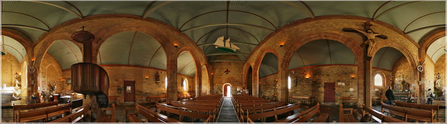
The bawdy song 'Les Filles de Camaret' was probably written anonymously by Laurent Tailhade to avenge the Camarétois.
Panorama made of 12 photos taken on the 15 April 2008.
Click on the image to view the 360º panorama ! 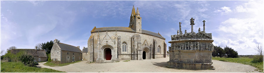
Calvary of Our Lady of Tronoà«n
Panorama made of 11 photos taken on the 12 April 2008.
Click on the image to view the 360º panorama ! 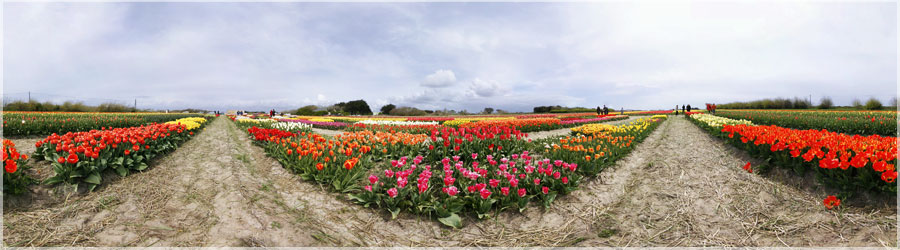
Tulips in St. Jean Trolimon
Panorama made of 11 photos taken on the 19 April 2008.
Click on the image to view the 360º panorama ! 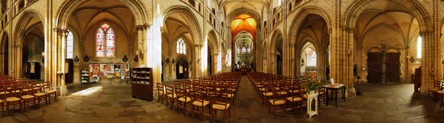
Cathedral of Saint Pol de Leon
Panorama made of 11 photos taken on the 16 April 2008.
Click on the image to view the 360º panorama ! 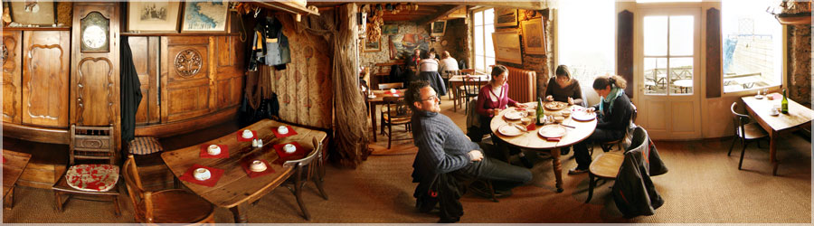
The view is wonderful, the pancakes are excellent, a nice break overlooking the sea!
Panorama made of 11 photos taken on the 22 March 2008.
Click on the image to view the 360º panorama ! 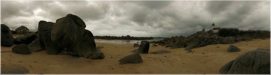
Beach of the tip Beg Pol
Panorama made of 8 photos taken on the 23 March 2008.
Click on the image to view the 360º panorama ! 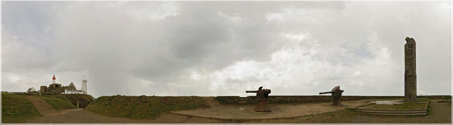
Memorial of the pointe St Mathieu
Panorama made of 10 photos taken on the 22 March 2008.
Click on the image to view the 360º panorama ! 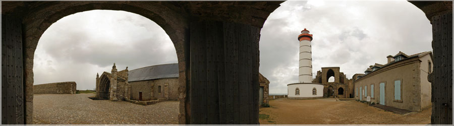
Lighthouse Pointe St Mathieu
Panorama made of 8 photos taken on the 22 March 2008.
Click on the image to view the 360º panorama ! 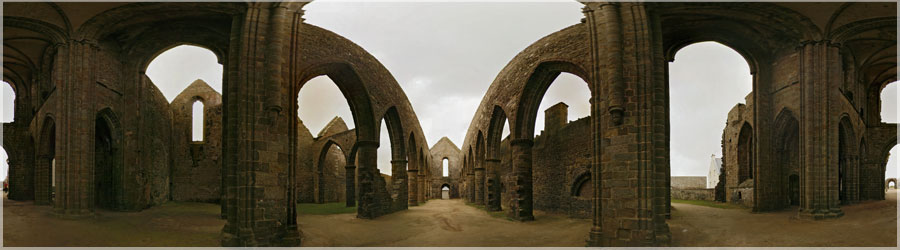
Ruins of the Abbey of the tip of St. Matthieu
Panorama made of 12 photos taken on the 22 March 2008.
Click on the image to view the 360º panorama ! 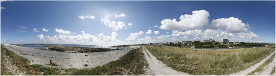
Guilvinec Beach: No, it's not a beach in the Riviera, but a beautiful beach in Brittany!
Panorama made of 58 photos taken on the 21 July 2007.
Click on the image to view the 360º panorama ! 
A game of hide and seek behind the huge stones of the beach Brignogan ?
Panorama made of 63 photos taken on the 09 February 2008.
Click on the image to view the 360º panorama !